-
Enterprise
Premium Parcels
 Roadway ROW
- Data Store
- Regrid App
- Esri Users
-
Resources
Support
Content
Programs
.png) Shop
Shop
- Contact Us
Broadband & Telecom
Manage Your Infrastructure, and Identify Opportunities with Comprehensive Location Data from Regrid
Identify Opportunities Using Regrid Nationwide Property Data
High-quality land parcel, building footprint, and validated property address data is crucial information for operations within the communications industry.
Know exactly where your network is performing well, or underperforming, with unit-level address validation.
-
-
- Target specific markets, capitalize on government incentive opportunities, and optimize planning processes.
- Identify demand, arrive at reliable data-driven decisions, and optimize operations at every level of the organization. Whether placing fiber in the ground, enabling service crews, or delivering services to end consumers you'll discover benefits and uncover insights with Regrid Property Data.
- Fastest coverage map expansion by industry standards, with data for 3,214+ counties covering >99.9% of the US population.
-
Empower Data-Drive Processes with High Quality Data Assets
Provide decision-makers with the resources they need to make smart, cost-efficient decisions about pivotal projects.
Regrid’s nationwide data solutions makes it frictionless for teams working with our parcel data to make informed decisions to optimize infrastructure and services.
Our Parcel Dataset of over 156 million property records powers business processes by providing current and actionable location data.
Easily Identify Land for Infrastructure
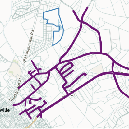
Regrid's right-of-way (ROW) indicator and Land Based Classification System (LBCS) is perfect for planning and building telecom infrastructure.
-
-
- The Land Based Classification System (LBCS) from Regrid allow users to quickly and consistently, identify like property types and speed workflows
- Right-of-way identification flags allow ROW geometries to be identified quickly so they can be appropriately incorporated into workflows without the guesswork.
- Clean identifiers for different property types with consistency and granularity allows for quicker decision making and project advancement.
-

Spiderweb ROW in Abbeville, SC.
Your Vision. Your Use Case. Regrid's Location Intelligence Solutions.
Get enterprise-grade data in a variety of formats
Present property boundaries & records in your own app with Parcel API
Visualize land parcel data in real-time with the Regrid Property App


.png?width=1200&length=1200&name=connected2fiberlogo%20(1).png)
Experience The Land Parcel Insight Powered by Regrid’s 3Cs
Coverage: Nationwide & Local Insight
Regrid’s parcel coverage spans across every city, county, and state. Explore the insights waiting for you in every corner of the country, including your own street.
Currency: Always Fresh Land Parcel Data
Get the edge of fresh land data precision. Regrid’s parcel data is continuously refreshed, guaranteeing that you have the latest and most dependable nationwide land parcel data.
Completeness: Parcel Boundaries & More!
Explore comprehensive data on land, ownership, buildings, and other related information. Acquire all the pertinent details on each parcel to enable you to make informed decisions.
Get the 3Cs and more when you complete the form next door.
Go for it!