regrid_tm_forest
Sign In
  • Products ⌄

    Regrid premium parcel data menu icon Premium parcels

    • global-icon Global parcels
    • US Parcel Data U.S. parcels
    • Europe-icon-navigation European parcels
    • Canada Parcel Data Canadian parcels
    • map-location-pin-regrid-icon U.S. coverage map

    ai-ml-navigation-icon (1) AI and ML tools

    • mcp-server-navigation MCP Server

    roadway-row-icon_2025-1 Roadway ROW

    • roadway-row-icon_2025 U.S. roadway polygons

    Spatial add-ons menu icon Spatial add-ons

    • Matched building footprints menu icon Matched building footprints
    • Matched secondary addresses menu icon Matched secondary addresses
    • Standardized zoning menu icon Standardized zoning
    • Enhanced property ownership menu icon Daily ownership updates

    Data access icon Delivery methods

    • Bulk files icon Bulk files
    • Feature Service Feature service
    • api-icon_2025 Parcel API and tiles
    • API Sandbox icon Interactive API sandbox
  • Industries ⌄

    industries-we-serve Industries we serve

    • aec-navigation-icon Architecture, engineering, and construction (AEC)
    • re-navigation-icon Real estate
    • gov-navigation-icon Government
    • ag-navigation-icon Agriculture
    • energy-navigation-icon Renewable energy and utilities
    • telco-navigation-icon Broadband and telecommunications
    • insurance-navigation-icon Insurance and finance
    • ai-ml-navigation-icon AI and machine learning
    • transportation-navigation-icon Transportation and logistics
  • Data store
  • Property App
  • Esri users
  • Resources ⌄

    Support menu icon Support

    • Support site menu icon Support site
    • Tutorial videos menu icon Tutorial videos
    • blog_resources_icon-1 Parcel schema
    • Regrid icon Sign into the Regrid Property App

    Content menu icon Content

    • Blog menu icon Blog
    • Customer stories menu icon Customer Stories
    • Reports menu icon Reports
    • data-store-2 Coverage map

    Programs menu icon Programs

    • academia_menu-icon Nonprofit & Academia
    • Regrid giving menu icon Regrid Giving
    • dwp-navigation-icon copy Data with Purpose

    shop icon Shop

    • merch_icon_2025 Regrid Merch
  • Contact us
Contact us
  • Products ⌄

    Premium parcels

    • Global parcels
    • U.S. parcels
    • European parcels
    • Canadian parcels
    • U.S. coverage map

    Spatial add-ons

    • Matched building footprints
    • Matched secondary addresses
    • Standardized zoning
    • Daily ownership updates

    AI and ML tools

    • MCP Server

    Delivery methods

    • Bulk files
    • Feature service
    • Parcel API and tiles
    • Interactive API sandbox

    Roadway ROW

    • U.S. roadway polygons
  • Industries ⌄

    Industries we serve

    • Architecture, engineering, and construction (AEC)
    • Real estate
    • Government
    • Agriculture
    • Renewable energy and utilities
    • Broadband and telecommunications
    • Insurance and finance
    • AI and machine learning
    • Transportation and logistics
  • Data store
  • Property App
  • Esri users
  • Resources ⌄

    Support

    • Support site
    • Tutorial videos
    • Parcel schema
    • Sign into the Regrid Property App

    Programs

    • Nonprofit & Academia
    • Regrid Giving
    • Data with Purpose

    Content

    • Blog
    • Customer Stories
    • Reports
    • Coverage map

    Shop

    • Regrid Merch
  • Contact us

Team Regrid

Meet the parcel people

Regrid is an industry-leading property data and location intelligence company. Like our parcel dataset, the Regrid team is nation-spanning, with team members across the U.S.

Do you know the Regrid story?

Founded in 2009 in Detroit, Michigan, Regrid spent its early years helping Detroiters use parcel data to overcome the challenges of widespread vacancy, blight, and foreclosure.

That very intense, very human experience showed us that parcel data must be made highly accessible to all audiences, and set us on a journey to bring parcels to every geography.

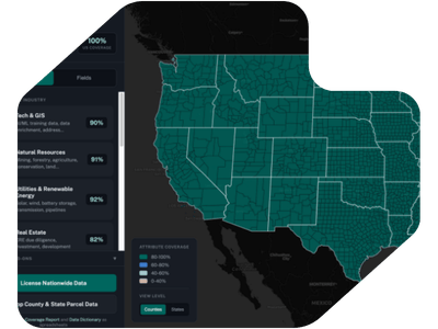
In 2023 Regrid became the first team to ever assemble and deliver a 100% parcel coverage map of the United States – a testament to our unique passion, care, and commitment.
In 2024, Regrid became Esri's commercial partner for parcel data. As the world leader in mapping software and geographic insight. Esri saw what sets Regrid apart and you will too.

Our founders

mary-headshot

Mary Carter
COO & Co-founder

jerry-headshot

Jerry Paffendorf
CEO & Co-founder

larry-headshot

Larry Sheradon
CTO & Co-founder

group-pic-retreat_10142024 (2)
logo

(888) 4RE-GRID

  • Contact Us
  • Customer Support
  • Privacy Policy
  • Terms of Use
  • Cookie Preferences

Subscribe for email updates

Company

  • About Regrid
  • Careers
  • Press
  • Shop Regrid Merch

Resources

  • Coverage Map
  • Support Center
  • Reports
  • Regrid Status Page

Enterprise Solutions

  • U.S. Parcels
  • Canada Parcels
  • Parcel & Tiles API
  • Roadway Right-of-Way

Self-Serve Solutions

  • Regrid Property App
  • Shop the Data Store
  • API Monthly Plans