
-
Products ⌄
 Premium parcels
.png) AI and ML tools
AI and ML tools
 Roadway ROW
- Industries ⌄
- Data store
- Property App
- Esri users
- Resources ⌄
- Contact us


.svg)


-
Products ⌄
AI and ML tools
Roadway ROW
-
Industries ⌄
-
Resources ⌄
REGRID GLOBAL
Boundaries without borders
The journey to borderless location intelligence begins here. We are actively scaling our foundational data structure into Europe, marking the first milestone in our vision to unify global parcels under a single schema

Bringing you international parcels, the Regrid way
We are bringing international parcel coverage to your workflow with the same reliable delivery options you use today. No searching, no normalizing, and no tedious maintenance. Just clean, standardized land data ready for enterprise.

22
countries
and counting


Compliance by design
Operate with confidence. Our geometry-first data omits personal data like owner names entirely so it stays outside the scope of GDPR and similar privacy regimes.

One consistent schema
Skip the data wrangling. We normalize international datasets into our core parcel schema so you can instantly reuse your existing models and workflows across new geographies.

Purchase a single country or a bundle
Get immediate, countrywide coverage for the United States, Canada, or numerous European countries delivered via bulk data exports, API, Feature Service, or Tile Server.

Shape the global roadmap
We are actively expanding our footprint based on client demand. By engaging with us early, your specific target countries and use cases will directly prioritize what we map next.
Who it's for
One schema. No borders. Supporting global goals.
When land data stops at the border, global growth stalls. By unifying international parcel boundaries into a single data structure, Regrid empowers cross-border innovators to scale their platforms without rewriting their code.


Parcel data for the markets you work in
From complete U.S. coverage to Canadian parcels and a growing European footprint, Regrid brings standardized land data into the workflows, systems, and decisions your team depends on.-
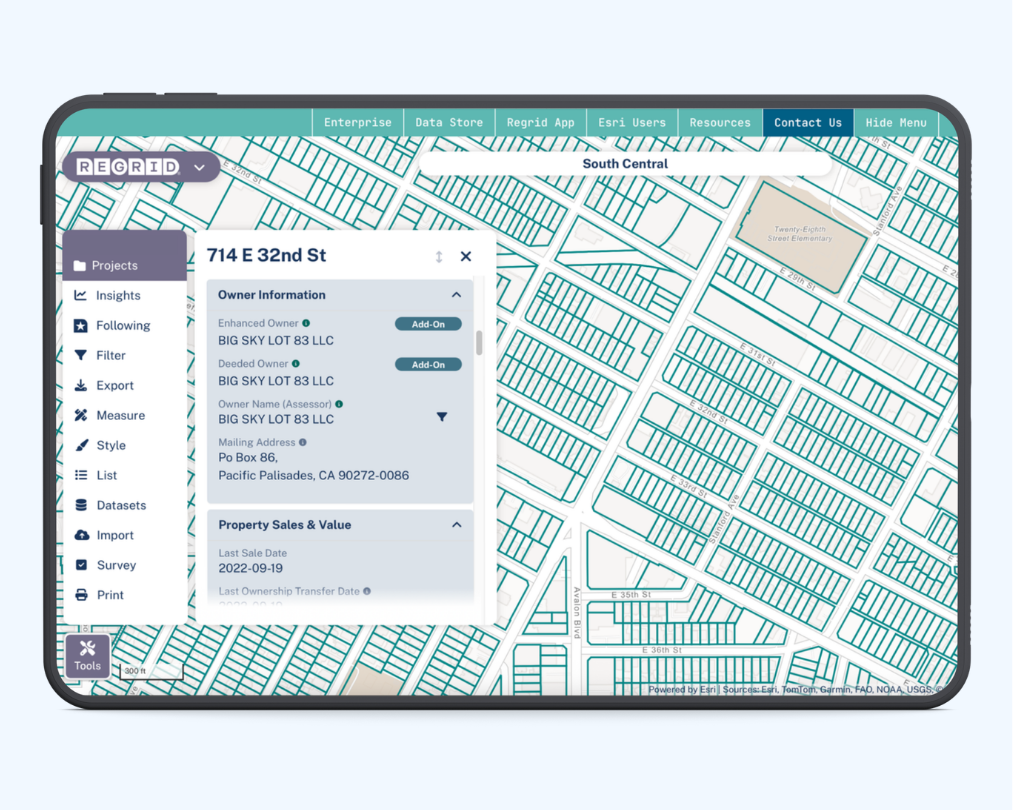
Comprehensive nationwide parcel data enriched with property attributes, buildings, addresses, zoning, and geographic context — delivered in the formats enterprise teams need.
-
Explore millions of parcel boundaries across Canadian provinces and territories through one consistent source, with flexible delivery for GIS, data, and application workflows.
-
Scale across borders with standardized European parcel data across 20 countries and counting, built for teams that need reliable land data beyond one market.
Our industries
See how Regrid supports global industries
AEC
Plan, design, and deliver projects with reliable parcel context for sites, ownership, zoning, buildings, addresses, and surrounding land conditions.
Learn more
Real
Estate
Use standardized parcel data to evaluate properties, compare markets, identify opportunities, and connect real estate decisions to accurate location intelligence.
Learn more
Government
Support planning, permitting, service delivery, and land management with parcel data that helps public-sector teams understand properties at scale.
Learn more
Agriculture
Make better rural land decisions with standardized parcel boundaries, ownership data, and property context for acquisition, operations, forestry, and land analysis.
Learn more
energy and
utilities
Plan, site, connect, and maintain infrastructure with parcel data that links projects to ownership, land use, buildings, addresses, and local property context.
Learn more
Broadband & telecom
Plan expansion, validate serviceable locations, and connect network decisions to parcels, addresses, buildings, ownership, and coverage areas.
Learn more
insurance &
finance
Connect property, ownership, valuation, building, and risk data to support underwriting, lending, portfolio analysis, and property intelligence workflows.
Learn more
AI & machine Learning
Build models and analytics workflows on standardized parcel data that connects property boundaries, ownership, land use, buildings, and location context.
Learn more
Transportation & logistics
Use parcel data to understand where destinations, service areas, infrastructure, and stakeholders connect to the land for routing, planning, and mobility decisions.
Learn more
You're in great company


(888) 4RE-GRID
Subscribe for email updates