regrid_tm_forest
Sign In
  • Products ⌄

    Regrid premium parcel data menu icon Premium parcels

    • global-icon Global parcels
    • US Parcel Data U.S. parcels
    • Europe-icon-navigation European parcels
    • Canada Parcel Data Canadian parcels
    • map-location-pin-regrid-icon U.S. coverage map

    ai-ml-navigation-icon (1) AI and ML tools

    • mcp-server-navigation MCP Server

    roadway-row-icon_2025-1 Roadway ROW

    • roadway-row-icon_2025 U.S. roadway polygons

    Spatial add-ons menu icon Spatial add-ons

    • Matched building footprints menu icon Matched building footprints
    • Matched secondary addresses menu icon Matched secondary addresses
    • Standardized zoning menu icon Standardized zoning
    • Enhanced property ownership menu icon Daily ownership updates

    Data access icon Delivery methods

    • Bulk files icon Bulk files
    • Feature Service Feature service
    • api-icon_2025 Parcel API and tiles
    • Green icon of a shopping cart with check mark Data store
  • Industries ⌄

    industries-we-serve Industries we serve

    • aec-navigation-icon Architecture, engineering, and construction (AEC)
    • re-navigation-icon Real estate
    • gov-navigation-icon Government
    • ag-navigation-icon Agriculture
    • energy-navigation-icon Renewable energy and utilities
    • telco-navigation-icon Broadband and telecommunications
    • insurance-navigation-icon Insurance and finance
    • ai-ml-navigation-icon AI and machine learning
    • transportation-navigation-icon Transportation and logistics
  • Data store
  • Property App
  • Esri users
  • Resources ⌄

    Support menu icon Support

    • Support site menu icon Support site
    • Tutorial videos menu icon Tutorial videos
    • blog_resources_icon-1 Parcel schema
    • Regrid icon Sign into the Regrid Property App

    Content menu icon Content

    • Blog menu icon Blog
    • Customer stories menu icon Customer Stories
    • Reports menu icon Reports
    • data-store-2 Coverage map

    Programs menu icon Programs

    • academia_menu-icon Nonprofit & Academia
    • Regrid giving menu icon Regrid Giving
    • dwp-navigation-icon copy Data with Purpose

    shop icon Shop

    • merch_icon_2025 Regrid Merch
  • Contact us
Contact us
  • Products ⌄

    Premium parcels

    • Global parcels
    • U.S. parcels
    • European parcels
    • Canadian parcels
    • U.S. coverage map

    Spatial add-ons

    • Matched building footprints
    • Matched secondary addresses
    • Standardized zoning
    • Daily ownership updates

    AI and ML tools

    • MCP Server

    Delivery methods

    • Bulk files
    • Feature service
    • Parcel API and tiles
    • Data store

    Roadway ROW

    • U.S. roadway polygons
  • Industries ⌄

    Industries we serve

    • Architecture, engineering, and construction (AEC)
    • Real estate
    • Government
    • Agriculture
    • Renewable energy and utilities
    • Broadband and telecommunications
    • Insurance and finance
    • AI and machine learning
    • Transportation and logistics
  • Data store
  • Property App
  • Esri users
  • Resources ⌄

    Support

    • Support site
    • Tutorial videos
    • Parcel schema
    • Sign into the Regrid Property App

    Programs

    • Nonprofit & Academia
    • Regrid Giving
    • Data with Purpose

    Content

    • Blog
    • Customer Stories
    • Reports
    • Coverage map

    Shop

    • Regrid Merch
  • Contact us


REGRID ENHANCED OWNERSHIP

Keep property ownership data up to date

Add frequently updated owner names, mailing addresses and deed ownership information to Regrid parcel data — matched back to each parcel with a stable Regrid ID.
 
Contact enterprise sales
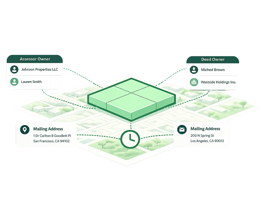
Schematic depiction of Enhanced Ownership
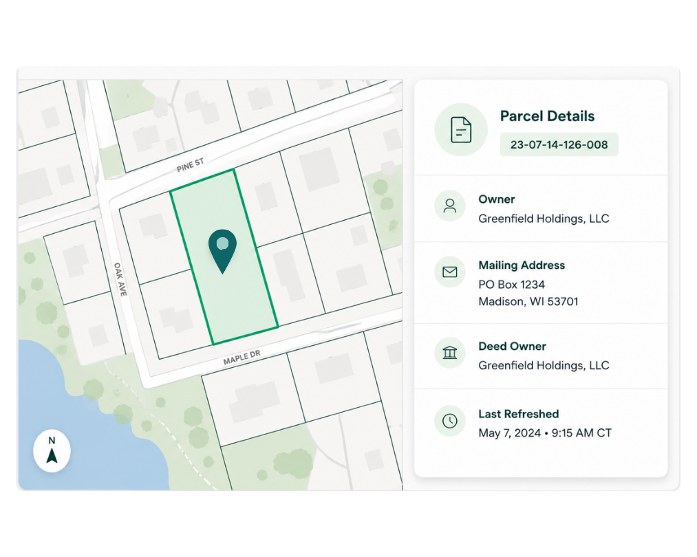
A map displaying parcel details, including owner information, mailing address, deed owner, and last refreshed date.

What it is

More current ownership context for every parcel

Enhanced Ownership adds a dedicated ownership record to Regrid parcel data, with updates provided to Regrid daily.

See ownership information from assessor records alongside deed ownership from county recorder records, plus owner mailing addresses and information about when the ownership record was last refreshed.

Because local authorities update on different schedules, currency varies by county. Regrid makes that currency visible so you can understand how current the ownership information is for the parcel you are working with.

What's included

Go beyond a single owner field

Assessor ownership

Access the primary owner plus additional owner records where available, including parsed name components for as many as four owners.

Owner mailing address

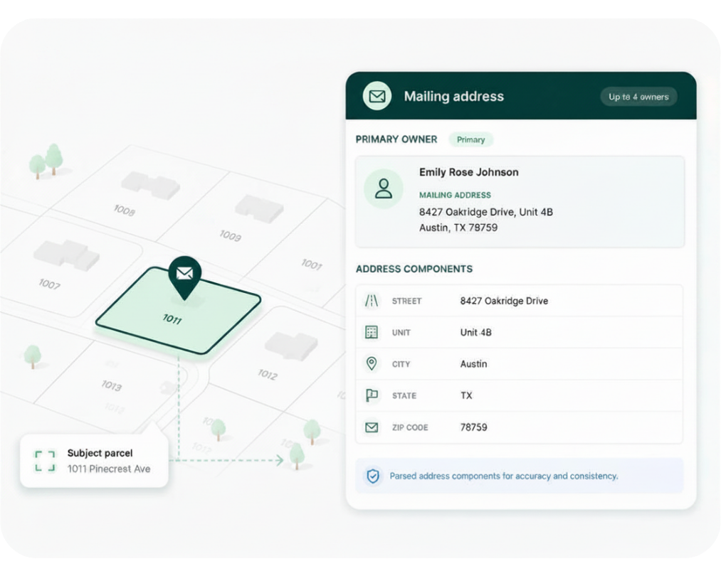
Work with the owner's mailing address and its component fields, including street, unit, city, state and ZIP information.

Deed ownership

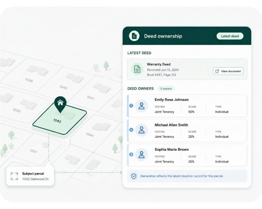
See ownership recorded on the latest deed, including fields for multiple deed owners.

Record currency

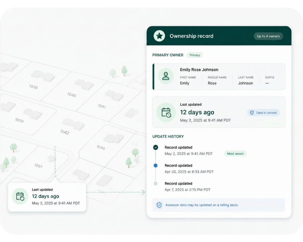
See when the assessor ownership record for an individual property was last updated, giving you greater visibility into data currency.
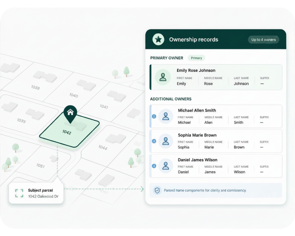
Assessor ownership
Assessor ownership
A map with a highlighted parcel and callouts next to a UI panel titled “Mailing address,” showing the primary owner and address components like street, unit, city, state, and ZIP code.
Map view highlighting a property lot labeled 1042 Oakwood Dr beside a desktop dashboard titled “Deed ownership,” listing owners with document links and tenancy details.
Dashboard UI showing an ownership record with a primary owner profile, last-updated time, and update history timeline beside a map with highlighted address markers and a last-updated card.

Delivery methods

Use Enhanced Ownership in your existing workflow

For new customers, Enhanced Ownership is available through the Regrid Parcel API and Feature Service. Existing customers with a Bulk Data Delivery licence may also receive Enhanced Ownership through their established bulk delivery workflow.

Parcel API and tiles

Accounts with Enhanced Ownership enabled can access the additional ownership records alongside parcel results through Regrid’s Parcel API.
Build with Regrid

Regrid feature service

Enhanced Ownership is available as a related non-spatial table within Regrid’s Esri-compatible Feature Service, connecting ownership records directly to their corresponding parcels in ArcGIS workflows.
Explore Regrid Feature Service

Add more current ownership context to your parcel data

Talk to us about adding Enhanced Ownership to your Regrid parcel data and accessing it through the workflow that works for your team.

*required
CREtelligent logo
Esri Logo
Autodesk logo
Langan logo
Burns & McDonnell logo
Agcor logo
Bloom Spatial logo
UC Berkeley logo
Upstream Tech logo
Crexi logo
Dycom logo
CQA logo
TomTom logo
Amazon logo
Polaris logo
United States Census Bureau logo
BCG logo

Frequently asked questions

  • Regrid receives Enhanced Ownership updates daily, but currency varies by county because local authorities provide updates on different schedules. The eo_lastrefresh field shows when ownership information for an individual parcel was last refreshed, giving you visibility into how current the record is.

  • The owner in eo_owner comes from the county assessor’s certified assessor file. The deed owner in eo_deedowner comes from the county recorder and reflects the name recorded on the deed. The two will generally be in sync, but there can be differences between them.

  • Deed recordings are received more frequently than certified assessor files. Regrid uses those records to update the owner information while the next certified tax file is pending.

  • No. Regrid updates a record when one of its fields changes, but that change could be an updated mailing address, corrected spelling, formatting adjustment or another detail rather than a change in ownership.

  • Enhanced Ownership records are linked to Regrid parcels using ll_uuid, Regrid’s stable parcel identifier across updates. Each Enhanced Ownership record also has its own stable attom_id, identifying the matched ownership record.

  • Bulk delivery of Enhanced Ownership is no longer available to new customers. Regrid continues to support bulk delivery for customers who are already licensed for it, with update files delivered through their existing SFTP or cloud workflow.
logo

(888) 4RE-GRID

  • Contact us
  • Customer support
  • Privacy policy
  • Terms of use
  • Cookie Preferences

Subscribe for email updates

Company

  • About Regrid
  • Careers
  • Press
  • Shop Regrid merch

Resources

  • Coverage map
  • Support center
  • Reports
  • Regrid status page

Enterprise Solutions

  • U.S. parcels
  • Canada parcels
  • Europe parcels
  • Parcel and tiles API
  • Roadway Right-of-Way

Self-serve solutions

  • Regrid Property App
  • Shop the Data Store
  • API monthly plans