
-
Products ⌄
 Premium parcels
.png) AI and ML tools
AI and ML tools
 Roadway ROW
- Industries ⌄
- Data store
- Property App
- Esri users
- Resources ⌄
- Contact us


.svg)


-
Products ⌄
AI and ML tools
Roadway ROW
-
Industries ⌄
-
Resources ⌄

INDUSTRIES
Nationwide parcel data for renewable energy and utilities
Regrid gives energy and utility teams the parcel context they need to plan projects, evaluate sites, and support GIS, analytics, and field workflows across the U.S.
Land decisions sit behind every energy project
When parcel data varies by county, project, or team, planning slows down. A standardized parcel layer gives energy and utility teams a cleaner foundation for siting, outreach, analysis, and delivery.

100%
U.S. Parcel
data coverage

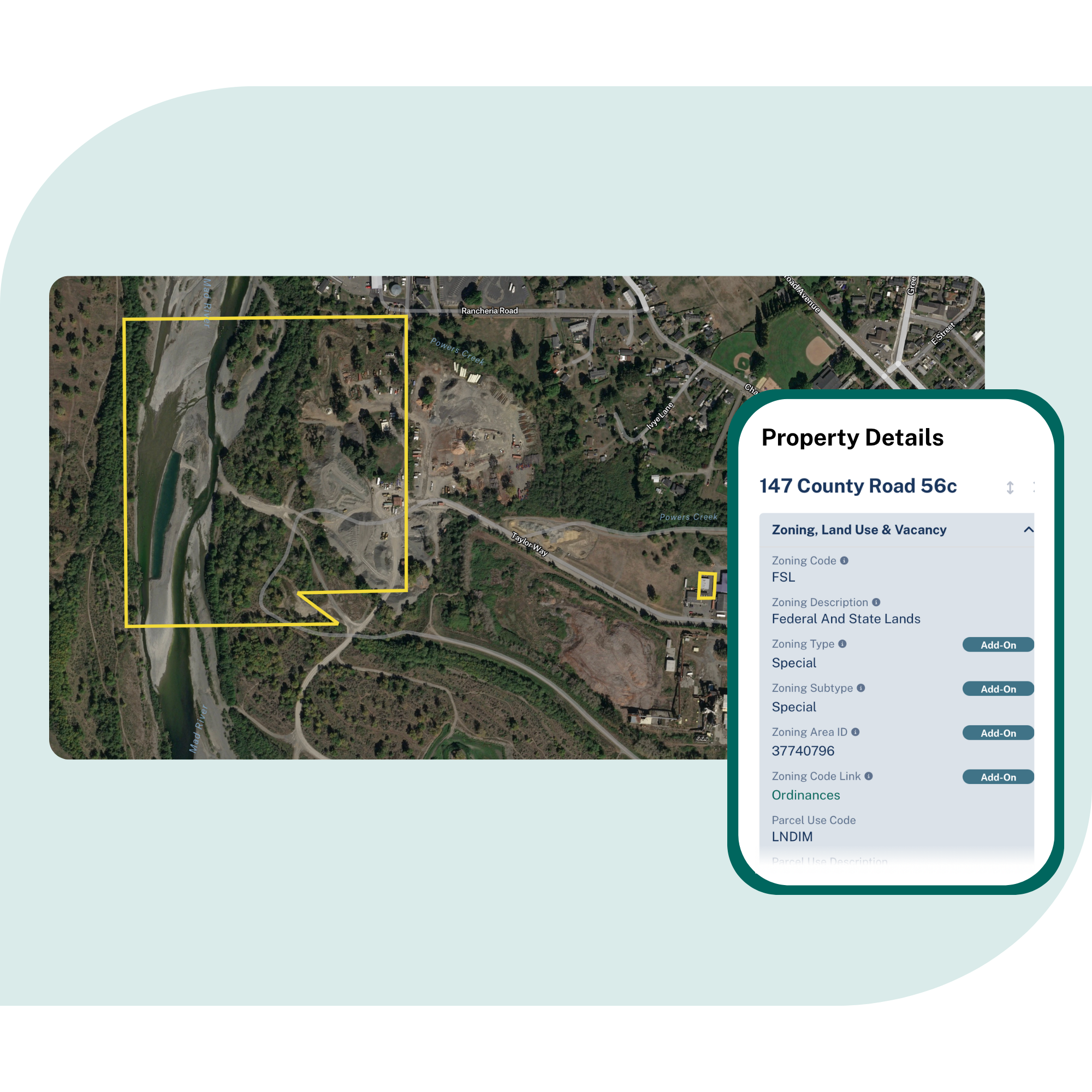
Screen sites with better property context
Compare parcels using boundaries, ownership, acreage, zoning, land use, buildings, addresses, and valuation before deeper feasibility work begins.

Connect assets to the land around them
Join service points, facilities, routes, customer records, and internal datasets to parcels so planning and operations share the same property reference.

Keep maps, apps, and field workflows aligned
Deliver parcel data through Feature Service, API, tiles, or bulk files so GIS teams, analysts, field crews, and partners can work from the same foundation.
Built for core energy and utilities workflows
See how a standardized parcel layer supports planning, development, service, and operations
Renewable site screening and feasibility
Compare parcel size, ownership, zoning, land use, building context, and surrounding property patterns across counties to narrow the shortlist faster.

Transmission and distribution planning
Map proposed routes against parcels, owners, addresses, and roadway or rail corridors to support early planning, review, and coordination.
Right-of-way and land acquisition support
Build owner and mailing lists from selected parcels and buffers. Keep outreach, acquisition, and project records tied to stable parcel IDs as routes evolve.
Service expansion & customer reach
Understand who and what sits inside a target area. Estimate customer reach, identify served and unserved properties, and plan expansion with clearer property context.
Field planning and site visits
Give crews parcel boundaries, ownership context, addresses, and notes in the field so site checks, inspections, and follow-up work stay connected to the right property.
Energy maps, apps, and analytics
Serve fast parcel overlays through tiles and API, or use bulk files for modeling and internal analysis. Keep property context consistent across tools and teams.
You're in great company


Trusted by energy and utilities teams
Regrid supports renewable energy producers, utilities, analysts, and software teams that need reliable parcel data for planning, service, and infrastructure decisions.
Renewable development
A leading solar and wind development company used Regrid’s nationwide parcel coverage and standardized property attributes to support site selection and early-stage analysis.
Rural utility operations
Cooperative Energy used Regrid parcel data and an Esri-compatible Feature Service to improve access to parcel context across rural service areas and support more efficient collaboration.
Large-scale site analysis
An energy company used Regrid to add millions of United States parcels into its geospatial workflows, helping teams analyze properties, manage assets, and query locations at scale.
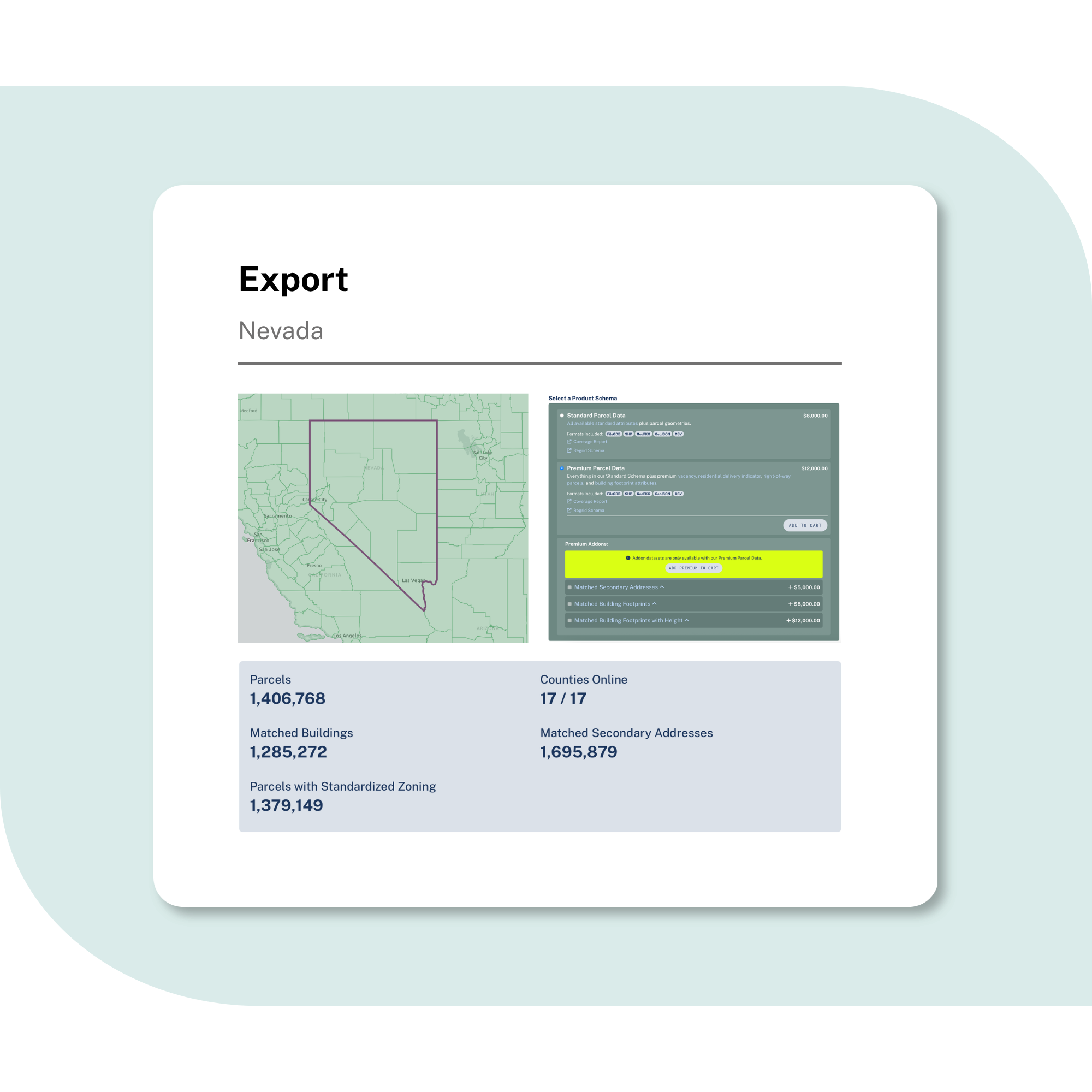
Explore the coverage map
See live coverage, refresh dates, and attribute completeness. Click any county to see parcel counts and field-by-field coverage, then continue to purchase or explore data in the Regrid web app.

What you get

-
Parcel boundaries and sizes, owner names and mailing addresses, zoning, land use, property valuation, buildings, addresses, and stable parcel IDs in one consistent structure.
-
Coverage across every U.S. county, including urban, suburban, and rural areas. Regrid keeps parcel data refreshed so planning reflects current ownership, addresses, buildings, and property changes.
-
Use Feature Service for Esri workflows, API and tiles for internal apps and portals, or bulk delivery for modeling, analytics, and enterprise data systems.
Frequently asked questions
-
It means parcel coverage across every U.S. county, delivered in a standardized structure that can support projects across service territories, regions, and states without county-by-county sourcing.
-
Yes. Regrid data can help teams compare parcels by size, ownership, zoning, land use, building context, and surrounding property patterns. This gives renewable developers a cleaner starting point before deeper feasibility, engineering, or field review.
-
Regrid data helps teams understand the parcel and ownership context around proposed routes, corridors, assets, and service areas. Regrid’s Roadway ROW product can also help identify roadway and rail right-of-way corridors for planning use cases. It does not replace legal review, field studies, or survey-grade easement research.
-
Yes. Teams can match internal records to parcels using addresses, parcel IDs, spatial joins, or location coordinates, then use parcels as a stable reference across maps, analysis, exports, and applications.
-
Yes. Regrid offers multiple delivery methods, including Feature Service, API, tiles, and bulk files, so parcel data can support Esri workflows, internal applications, analytics pipelines, and field tools.
-
Regrid refreshes parcel data on an ongoing basis and publishes coverage, refresh dates, and attribute completeness so teams can understand what is available in each county before they build around it.

(888) 4RE-GRID
Subscribe for email updates