


.png)


.svg)


.jpg)
Regrid’s Feature Service + Michigan Geological Survey’s Triage Project
When the Michigan Geological Survey’s Triage Project needed to validate and quality control the locations of hundreds of thousands of water wells across the state of Michigan – a critical part of PFAS contamination monitoring and remediation – they turned to Regrid’s Data With Purpose program and Regrid’s Esri Feature Service to supercharge their effort.
Learn More About Regrid’s Nationwide Parcel Data and Apply to Data With Purpose Here
“Previously, we had to manually and visually assess the plotted location of each individual well point. Now, we are able to process up to 60% of a given county’s well data using a Michigan Geological Survey-developed ArcPython script which depends on Regrid parcel data and the Esri-compatible Regrid Feature Service. This has dramatically increased our productivity.”
Evie Murgia
Project Manager of the Triage Project
When PFAS contamination concerns arise in Michigan, experts turn to the Michigan Department of Environment, Great Lakes and Energy’s Wellogic database. However, as the Michigan Geological Survey found as they began validating the state’s well water location data in 2019, nearly 40% of the well location data was inaccurate and the locations of more than 700,000 wells in the state were not digitized. Even when PFAS contamination was identified, it was difficult to know which wells were affected.
.jpg?width=452&height=265&name=mgs_graphoferror%20(1).jpg)
Image courtesy of Michigan Geological Survey’s Triage Project
These findings led to the grant-funded Triage Project at the Michigan Geological Survey. The goal of the small team behind the Triage Project is to validate and enhance the existing Wellogic water well database. More accurate and reliable well water location data in turn produces more accurate and reliable hydrogeologic maps for all state programs, and better informed responses to PFAS contamination.
At first, the work of the Triage Project was slow and painstaking. Lack of available land parcel data across the state meant that the Triage Project relied on inconsistent county parcel viewers to validate well location data – if those parcel viewers were available at all. Automation of validating well locations was out of the question.
In the summer of 2022, the Triage Project applied to Regrid’s Data With Purpose program. The Data With Purpose program makes Regrid’s parcel data and software available to nonprofits, researchers, and academics on a “pay what you can” basis. The Triage Project was eager to use our brand new Esri-compatible Regrid Feature Service, which would make Regrid’s nationwide parcel data available to the Triage Project through ArcPro and ArcGIS Online.
Today, the Triage Project is building the Wellogic database faster than ever before and is able to respond to PFAS contamination concerns much faster.
What follows is a Q&A with Evie Murgia of the Triage Project.
Some responses have been modified for length:
Tell us about the Triage Project at Western Michigan University – what do you all do?
The Michigan Geological Survey is currently working on a project for the Michigan Department of Environment, Great Lakes and Energy (EGLE), Water Resource Division (WRD) in response to state-wide PFAS contamination concerns and high-capacity water withdrawals. During our initial response to those concerns, it was found that a significant portion of water well location data in the state’s database was errored, and that a wealth of historical data (700,000 wells) had yet to be digitized and input to the database.
This inaccuracy and lack of data made it difficult to not only produce a variety of reliable hydrogeological maps, but to simply locate a water well down gradient from an impact for field testing. These issues gave rise to the grant-funded MGS Triage project.
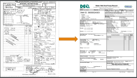
Image courtesy of MGS Triage Project showing an undigitized well location record
vs. a record digitized by MGS Triage Project
What problem did you encounter that led you to apply for the Data With Purpose program with Regrid?
Our primary challenge that Data With Purpose assists with is accessing quality and accurate parcel data.
Previously, we relied on individual counties’ parcel viewer applications. These vary in quality, formatting, availability, and cost. Because the data across different parcel viewer applications varies, we were unable to automate any of our procedures. This also made any effort in consolidating multi-county data and performing assessments on areas spanning different counties more labor-intensive and time-consuming than it needed to be. Some of these counties that have publicly available parcel data did not have a user-friendly application to be able to view the data either.
How did the Esri-compatible Regrid Feature Service and the Data With Purpose program change how you do your work?
Likely the most impactful development with access to Regrid’s data and feature service is the ability for us to partially automate our well location validation process. The well location is arguably the singular most valuable field, and most important to have correct. As such, an entire phase of the Triage Project is dedicated solely to this effort.
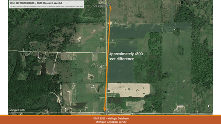
Image courtesy of MGS Triage Project showing example of recorded vs. actual well location
Previously, we had to manually and visually assess the plotted location of each individual well point. Now, we are able to process up to 60% of a given county’s well data using a Michigan Geological Survey-developed ArcPython script which depends on Regrid data and the provided feature service. This script drastically increased productivity. We were additionally able to program in a suggested location for datapoints unable to be processed by the script where data was limited by what was provided in the original well record.
Were there any additional benefits you experienced as a result of working with Regrid that you may not have expected?
One unexpected benefit of working with Regrid is their exceptional company culture. Everyone we’ve interacted with has been incredibly supportive, helpful, and knowledgeable. Furthermore, they have displayed a genuine interest in the project and appreciation for the primary objective and subsequent impact on Michigan public health and safety, despite being a nationwide company.
Can you give an example or two of instances where the Triage Project responded to water issues that people might be familiar with?
One of the most recognizable instances of PFAS contamination in Michigan is that of the Wolverine Worldwide factory along the Rogue River in Rockford, Michigan, just north of Grand Rapids.
As a byproduct of the leather tanning process in shoe manufacturing, high concentrations of PFAS were released into the local watershed, later found to have negatively impacted the health of those drinking water from the affected area. Though investigations were conducted by multiple entities, nearly all of the water well data used in any of these analyses were validated and/or created by the Michigan Geological Survey.
As a result of such investigations, Wolverine Worldwide was fined several million dollars to pay out to harmed property owners. Residents on the affected water supply have since either been placed on treated public well supplies or installed filters specified for the removal of most PFAS compounds.
Regrid’s Data With Purpose is a non-profit organization and academia support program. Projects that directly assist communities or advance our shared understanding of land and geographies may apply to use our parcel data on a ‘pay what you can’ basis.
