Regrid logo, registered trademark
  • Enterprise Solutions

    Regrid parcel data Regrid Parcel Data

    Bulk files delivered in the format your business needs.

    • parcel -data Nationwide Parcel Data
    • matched building footprints menu icon Matched Building Footprints
    • matched secondary addresses menu icon Matched Secondary Addresses
    • enhanced ownership menu icon Enhanced Ownership

    feature service menu icon Regrid Feature Service

    Get data delivery straight into your Esri-stack, no custom integration required.

    regrid api menu icon Regrid API

    Integrate parcel boundaries & records into your app, SaaS, or map.
    • Parcel and Tiles APIcon Parcel & Tiles API
    • typeahead api icon Typeahead API
  • Self Serve Options

    Regrid Property App menu icon Regrid Property App

    Take Regrid property data wherever you go - available for web, iOS, & Android.

    data-store-2 Shop the Data Store

    Instantly download parcel geometries & associated records, by county and state.

    self-serve parcel api menu icon API Monthly Subscriptions

    Sign up and try this nationwide parcel API, free for 7 days.

    api sandbox icon Interactive API Sandbox

    Explore the API Sandbox with complete feature access to 7 counties plus Puerto Rico.
  • Markets

    Regrid for Broadband Market Broadband

    Regrid for data science Data Science

    Esri environments Esri Users

    Parcel data for green initiatives Sustainable Initiatives

    Parcel data for real estate Real Estate

    Parcel data for nonprofit and academia Nonprofit & Academia

    Regrid's Data With Purpose program - propose your own budget to access land parcel data. 

    Plus sign icon Your Business or Organization

    Regrid’s data spans all industries needing land insight.
  • Resources

    support menu icon Support

    Access documentation & support materials to learn about Regrid data.
    • Support site resource icon Support Site
    • tutorial videos resources icon Tutorial Videos
    • parcel data faqs resources icon Parcel Data FAQs
    • property app faqs Property App FAQs
    • coveragemap_resources_icon Coverage Map
    • land use codes menu item Land Use Codes
    • vacancy data menu icon Vacancy Data

    content resources menu icon Content

    Dive into Regrid's world of land parcels & learn about location intelligence.
    • blog resources icon Blog
    • webcasts resources icon Webcasts
    • reports resources icon Reports
    • podcast resources icon Living In The Map

    customers resources icon Customers

    Hear what our customers say have to say & see how they use Regrid data.
    • testimonials resources icon Testimonials
    • Case Studies resources icon Case Studies
  • Contact Us

    Contact a parcel data expert menu icon Contact A Parcel Data Expert

    Contact Regrid parcel data experts to learn more about our offerings.

    Customer Support menu icon Customer Support

    Contact our customer support team & get the help you need.

    megamenu nav image Press & Media Inquires

    Find the information you need & get in touch with our marketing department.
  • Go To Map
Go To Map
  • Enterprise Solutions

    Regrid Parcel Data

    • Nationwide Parcel Data
    • Matched Building Footprints
    • Matched Secondary Addresses
    • Enhanced Ownership

    Regrid Feature Service

    Regrid API

    • Parcel & Tiles API
    • Typeahead API
  • Self Serve Options

    Regrid Property App

    Shop the Data Store

    API Monthly Subscriptions

    Interactive API Sandbox

  • Markets

    Broadband

    Data Science

    Esri Users

    Sustainable Initiatives

    Real Estate

    Nonprofit & Academia

    Your Business or Organization

  • Resources

    Support

    • Support Site
    • Tutorial Videos
    • Parcel Data FAQs
    • Property App FAQs
    • Coverage Map
    • Land Use Codes
    • Vacancy Data

    Content

    • Blog
    • Webcasts
    • Reports
    • Living In The Map

    Customers

    • Testimonials
    • Case Studies
  • Contact Us

    Contact A Parcel Data Expert

    Customer Support

    Press & Media Inquires

  • Go To Map

Regrid Reports

Check out the official reports on customer property survey and data analyses projects using the Regrid Parcel Data

Regrid Blog

Living In The Map

Categories

  • Reports
  • Use Cases
The Conservation Fund Saves Time & Money with Regrid's Feature Service

Regrid's Feature Service & The Conservation Fund

Alex Alsup September 6, 2023

How Regrid’s Feature Service is Delivering Nationwide Parcel Data and Powering Conservation

"Many elements of Regrid's Esri-compatible Feature Service have saved us time and money. What used to take 30 minutes to several hours searching for and downloading data county by county now takes 5 minutes. The Regrid Feature Service has enabled us to make more maps in-house and rely less on consultants for mapping services, thereby reducing unnecessary costs." - The Conservation Fund


Using Regrid parcel layer to select a project site

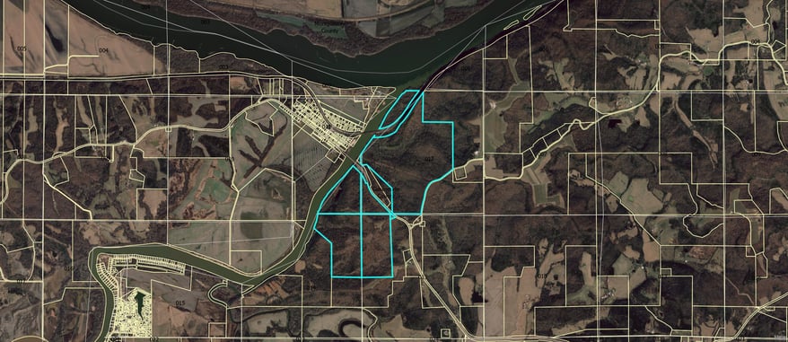
Using Regrid's parcel layer to select a project site - Image courtesy of The Conservation Fund


Land conservation at the nationwide scale requires the smooth delivery of reliable and up-to-date parcel data. Unfortunately for The Conservation Fund, the legacy data system they relied on to support land acquisition work, map making, and research often contained data too difficult to compile. It also demanded a laborious process that took up hours of valuable time: Searching a SharePoint database, downloading data, and importing it into ArcPro.


Parcel data that should have been a key tool for The Conservation Fund’s work was, instead, a barrier.


Enter Regrid's Feature Service, which connected The Conservation Fund to the nationwide parcel data they needed. Specifically crafted for GIS professionals, the Esri-compatible Feature Service fit The Conservation Fund’s needs.


How Regrid’s Esri-compatible Feature Service Works for The Conservation Fund:

  • Instant Integration: The Conservation Fund has a seamless connection with ArcGIS Pro and other application tools, made accessible through a simple URL integration.
  • Efficient Navigation: The Feature Service has provided The Conservation Fund with fast, efficient navigation across land parcels without any data wrangling.
  • Current Data Access: The Conservation Fund can now build a map with the most recent data available from Regrid, requiring nothing more than adding the Regrid Feature Service layer to an existing ArcPro project.

The Conservation Fund - Pea Ridge, AR

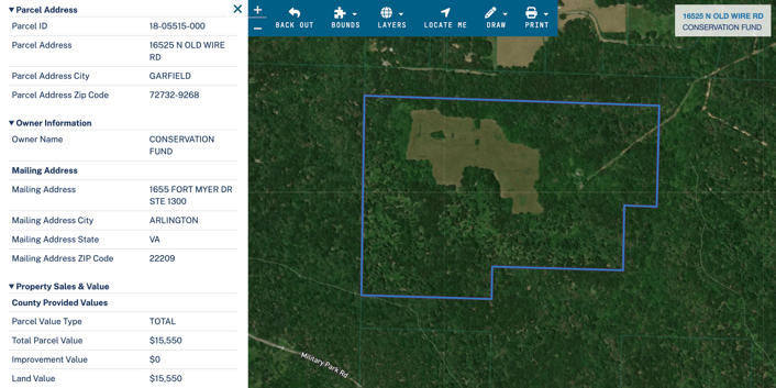
Conservation Fund parcel, Pea Ridge National Military Park, Arkansas with Regrid data - via Regrid.com


The transformation in The Conservation Fund's operations was significant:


  • Time Savings, in The Conservation Fund’s Words: “What used to take anywhere from 30 minutes to several hours searching for and downloading data county-by-county now takes about 5 minutes.  Running analysis on multiple counties or by state takes minutes instead of hours or days.”
  • Cost-Effective: With the Feature Service's ability to calculate acres directly, The Conservation Fund was able to make more maps in-house and reduce reliance on external consultants, slashing unnecessary costs.
  • Enhanced Workflow: The old workflow, full of repetitive tasks like downloading county data and calculating acres, was replaced with a streamlined process where adding the Regrid Feature Service layer was all it took to start mapping.
  • Improved Collaboration: Whether it was communicating with project managers or supporting field staff working on land acquisition, the Feature Service allowed for faster and more effective collaboration.
  • Unexpected Benefits: “The Feature Service has been extremely useful in helping us create spatial data for our Historic Project database as we are compiling data for over 4,000 conservation projects that we have completed since 1985.”

Regrid, said The Conservation Fund, is an “excellent source for parcel data” that’s both “extremely easy to use and effective at assisting us in locating and analyzing data for future conservation projects.”


Regrid Nationwide Parcel Data and the Regrid Feature Service as the deployment method solved a problem for The Conservation Fund and allowed them to revamp their approach to the GIS that supports their critical conservation work. It slashed both time and costs, while enabling The Conservation Fund to work more creatively and collaboratively.


TCF Historic Project Example-1
Screenshot from Historic Project database (using Regrid to compile the data)
Bergfried Project Site Map_page-0001
Image using Regrid parcel layer to select project site
A regional map of a subject property created from Regrid parcel data
Previous
logo

(888) 4RE-GRID

  • Contact Us
  • Customer Support
  • Privacy Policy
  • Terms of Use

Subscribe for email updates

Company

  • About Regrid
  • Careers
  • Press

Resources

  • Coverage Map
  • Support Center
  • Reports

Support

  • Parcel Data FAQs
  • Property App FAQs
  • Contact Support Team

Customers

  • Customer Stories
  • Case Studies
  • Non Profit & Academia

Enterprise Solutions

  • Nationwide Land Parcels
  • Parcel & Tiles API
  • Feature Service

Self-Serve Solutions

  • Regrid Property App
  • Shop the Data Store
  • API Monthly Plans