regrid_tm_forest
Sign In
  • Products ⌄

    Regrid premium parcel data menu icon Premium parcels

    • global-icon Global parcels
    • US Parcel Data U.S. parcels
    • Europe-icon-navigation European parcels
    • Canada Parcel Data Canadian parcels
    • map-location-pin-regrid-icon U.S. coverage map

    Spatial add-ons menu icon Spatial add-ons

    • Matched building footprints menu icon Matched building footprints
    • Matched secondary addresses menu icon Matched secondary addresses
    • Standardized zoning menu icon Standardized zoning
    • Enhanced property ownership menu icon Daily ownership updates
    • roadway-row-icon_2025-1 U.S. roadway polygons

    Data access icon Delivery methods

    • Bulk files icon Bulk files
    • Feature Service Feature service
    • api-icon_2025 Parcel API and tiles
    • API Sandbox icon Interactive API sandbox
  • Industries ⌄

    industries-we-serve Industries we serve

    • aec-navigation-icon Architecture, engineering, and construction (AEC)
    • re-navigation-icon Real estate
    • gov-navigation-icon Government
    • ag-navigation-icon Agriculture
    • energy-navigation-icon Renewable energy and utilities
    • telco-navigation-icon Broadband and telecommunications
    • insurance-navigation-icon Insurance and finance
    • ai-ml-navigation-icon AI and machine learning
    • transportation-navigation-icon Transportation and logistics
  • Data store
  • Property App
  • Esri users
  • Resources ⌄

    Support menu icon Support

    • Support site menu icon Support site
    • Tutorial videos menu icon Tutorial videos
    • blog_resources_icon-1 Parcel schema
    • Regrid icon Sign into the Regrid Property App

    Content menu icon Content

    • Blog menu icon Blog
    • Customer stories menu icon Customer Stories
    • Reports menu icon Reports
    • data-store-2 Coverage map

    Programs menu icon Programs

    • academia_menu-icon Nonprofit & Academia
    • Regrid giving menu icon Regrid Giving
    • dwp-navigation-icon copy Data with Purpose

    shop icon Shop

    • merch_icon_2025 Regrid Merch
  • Contact us
Contact us
  • Products ⌄

    Premium parcels

    • Global parcels
    • U.S. parcels
    • European parcels
    • Canadian parcels
    • U.S. coverage map

    Delivery methods

    • Bulk files
    • Feature service
    • Parcel API and tiles
    • Interactive API sandbox

    Spatial add-ons

    • Matched building footprints
    • Matched secondary addresses
    • Standardized zoning
    • Daily ownership updates
    • U.S. roadway polygons
  • Industries ⌄

    Industries we serve

    • Architecture, engineering, and construction (AEC)
    • Real estate
    • Government
    • Agriculture
    • Renewable energy and utilities
    • Broadband and telecommunications
    • Insurance and finance
    • AI and machine learning
    • Transportation and logistics
  • Data store
  • Property App
  • Esri users
  • Resources ⌄

    Support

    • Support site
    • Tutorial videos
    • Parcel schema
    • Sign into the Regrid Property App

    Programs

    • Nonprofit & Academia
    • Regrid Giving
    • Data with Purpose

    Content

    • Blog
    • Customer Stories
    • Reports
    • Coverage map

    Shop

    • Regrid Merch
  • Contact us

The Regrid Blog

Discover the Latest in Land Parcels & Spatial Data with the Regrid Team!

Categories

  • Announcements
  • Parcel Data Updates
  • Democratizing Data
  • Regrid Updates
  • Product How-To
  • Use Cases
  • All About Parcel Data
  • Customer & Guest Blogs
  • Working at Regrid
  • Regrid 100
  • Reports

Your Data on Landgrid Enterprise

Sahana Murthy January 9, 2020

Landgrid Enterprise

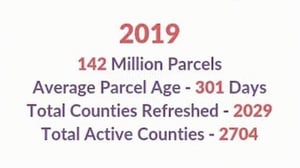
As of end of 2019, Loveland has aggregated 142 million parcels nationwide, all of which is meticulously mapped on the Landgrid Mapping Platform.

Not just that:

We refreshed - 2029 counties 

We have a total of - 2704 counties &

Best of all, our total average parcel age/currency is under a year right now!

Oh and how can I forget - We added the coveted USPS residential and vacancy indicators to our data.

2019 142 Million Parcels

But enough about the data we have! 

Let’s talk about YOUR Data!!! 

In today’s time, we know that everyone has & wants to work with their own datasets. You’ve spent years perhaps collecting the property data that you use for your day to day work - whether you are a county, Landbank, university, mapping company or operate in real estate, 

As a data company, we value ALL data.

So, Bring your own data to us and we will manage it and put it all up in one central location - Be it your own massive or small property dataset, mortgage data , census tract data or data that you may have collected using property & land surveys.

Landgrid Enterprise - Finally, all of your organization’s property data in one place, fully integrated with the software you need to do your work.

https://landgrid.com/enterprise

No matter the size & scale of your data - leave it to the Loveland team to manage & import it for you.

Doesn’t matter how your data is structured - whether its in one consolidated DB or in multiple siloes.

We can handle it. We will clean it, standardize it, even geocode it if necessary and add it on to the Landgrid platform under your account.

And voila --- you & your entire can visualize your data, build beautiful color coded maps and augment your data with unlimited land surveys straight out of your Enterprise account.

Couple that with custom capabilities and you have the dream property management solution that you never knew existed.

What do we mean by custom solutions:

Could be anything ranging from as small as :

  • custom reports 
  • to custom filters 
  • to custom data stats derived specifically for you, tailored to your analytic needs 
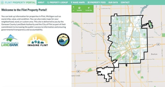
  • to an entirely custom site built just for you with your branding with embedded & interactive maps. Here’s an example of a made from scratch custom site that we built in partnership with the City of Flint & the Genessee county - https://flintpropertyportal.com/

Flint Property Portal


Sky’s the limit.

Don’t worry about the scale of your project either. 


Got an idea or need for an easy to use parcel data solution (No prior GIS experience required)???

Email us at enterprise@landgrid.com .

We can do a quick demo and get you a sense of what your solution could be - tailored just you.

Doesn’t get better than this. 

Lets handle your property data for you and make your life easy! How’s that for a 2020 resolution???


We look forward to hearing from you!

Enterprise Team!


Sahana Murthy

Previous Next
logo

(888) 4RE-GRID

  • Contact Us
  • Customer Support
  • Privacy Policy
  • Terms of Use
  • Cookie Preferences

Subscribe for email updates

Company

  • About Regrid
  • Careers
  • Press
  • Shop Regrid Merch

Resources

  • Coverage Map
  • Support Center
  • Reports
  • Regrid Status Page

Enterprise Solutions

  • U.S. Parcels
  • Canada Parcels
  • Parcel & Tiles API
  • Roadway Right-of-Way

Self-Serve Solutions

  • Regrid Property App
  • Shop the Data Store
  • API Monthly Plans