Regrid logo, registered trademark
  • Enterprise

    Regrid premium parcel data menu icon Premium Parcels

    • US Parcel Data U.S. Parcels
    • Canada Parcel Data Canadian Parcels
    • global-icon Global Parcels

    Spatial add-ons menu icon Spatial Add-Ons

    • Matched building footprints menu icon Matched Building Footprints
    • Matched secondary addresses menu icon Matched Secondary Addresses
    • Standardized zoning menu icon Standardized Zoning
    • Enhanced property ownership menu icon Daily Ownership Updates

    road icon Roadway ROW

    • Roadway polygons icon U.S. Roadway Polygons

    Data access icon Data Access

    • data-store-2 Coverage Map
    • blog_resources_icon-1 Parcel Schema
    • Bulk files icon Bulk Files
    • Feature Service Feature Service
    • api-icon_2025 Parcel API & Tiles
    • API Sandbox icon Interactive API Sandbox
  • Data Store
  • Regrid App
  • Esri Users
  • Resources

    Support menu icon Support

    • Support site menu icon Support Site
    • Tutorial videos menu icon Tutorial Videos

    Content menu icon Content

    • Blog menu icon Blog
    • Customer stories menu icon Customer Stories
    • Reports menu icon Reports

    Programs menu icon Programs

    • academia_menu-icon Nonprofit & Academia
    • Regrid giving menu icon Regrid Giving
  • Contact Us
Contact Us
  • Enterprise

    Premium Parcels

    • U.S. Parcels
    • Canadian Parcels
    • Global Parcels

    Roadway ROW

    • U.S. Roadway Polygons

    Spatial Add-Ons

    • Matched Building Footprints
    • Matched Secondary Addresses
    • Standardized Zoning
    • Daily Ownership Updates

    Data Access

    • Coverage Map
    • Parcel Schema
    • Bulk Files
    • Feature Service
    • Parcel API & Tiles
    • Interactive API Sandbox
  • Data Store
  • Regrid App
  • Esri Users
  • Resources

    Support

    • Support Site
    • Tutorial Videos

    Programs

    • Nonprofit & Academia
    • Regrid Giving

    Content

    • Blog
    • Customer Stories
    • Reports
  • Contact Us

The Regrid Blog

Discover the Latest in Land Parcels & Spatial Data with the Regrid Team!

Regrid Blog

Living In The Map

Categories

  • Announcements
  • Parcel Data Updates
  • Democratizing Data
  • Regrid Updates
  • Product How-To
  • Use Cases
  • Customer & Guest Blogs
  • All About Parcel Data
  • Working at Regrid
  • Regrid 100
  • Reports

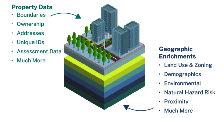
Expanding the definition of Premium Parcel Data with new Geographic Enrichments

Team Regrid January 28, 2025

Parcels are the foundation of every location decision, and Regrid is proud to be your choice for parcel data. 

Today we’re announcing new geographic data enrichments, produced in collaboration with our partner Esri, the world leader in digital geography. Property and geography form a complete picture of location, but they have long been artificially separated. The collection of data attributes we are releasing today is part of our effort to bring property and geography together in Regrid’s Premium Parcel Data to inform location intelligence and decisions.


premium-approach_012025


The new fields available in Regrid’s Premium Parcel Data, produced in partnership with Esri

8 Demographics fields from Esri’s Demographics team (calculated at the Census Block Group level and matched to individual parcels):

  • Housing Affordability Index 
  • Population Density 
  • Housing Units CAGR (Compound Annual Growth Rate) (past 5 years) 
  • Housing Units CAGR (5 yr forecast) 
  • Population CAGR (past 5 years) 
  • Population CAGR (5 yr forecast) 
  • Median Household Income (5 yr forecast) 
  • Median Household Income (current year)

2 Environmental fields:

  • Risk Rating from FEMA’s National Risk Index
  • Distance to Transmission Line from the Department of Homeland Security’s Homeland Infrastructure Foundation-Level Data

3 Elevation fields:

  • Roughness Rating from a 10 meter digital elevation model (DEM) produced by Esri from US Geological Survey data
  • Parcel Highest Elevation from the same
  • Parcel Lowest Elevation from the same

View our data dictionary for exact fields and descriptions


Our Premium Parcels are available within enterprise licenses (files, API and Feature Service) and our self-serve solutions including the Regrid Property App, the Data Store and the API.


They are the first of many future enrichments as we continue our work to unite property data and geographic insights, and continue to increase the value we deliver to clients working with Regrid Premium Parcel Data.

In addition to the new enrichments with Esri, we have also incorporated Precisely’s PreciselyID into our schema for easy matching with other datasets.

Learn more about Premium Parcels

image-Jan-27-2025-06-22-02-2010-PM


Previous Next
logo

(888) 4RE-GRID

  • Contact Us
  • Customer Support
  • Privacy Policy
  • Terms of Use

Subscribe for email updates

Company

  • About Regrid
  • Careers
  • Press

Resources

  • Coverage Map
  • Support Center
  • Reports
  • Regrid Status Page

Enterprise Solutions

  • U.S. Parcels
  • Canada Parcels
  • Parcel & Tiles API

Self-Serve Solutions

  • Regrid Property App
  • Shop the Data Store
  • API Monthly Plans