×
See Regrid's NEW Roadway ROW Data in Action!
Regrid logo, registered trademark
  • Enterprise

    Regrid premium parcel data menu icon Premium Parcels

    • US Parcel Data U.S. Parcels
    • Canada Parcel Data Canadian Parcels
    • global-icon Global Parcels

    Spatial add-ons menu icon Spatial Add-Ons

    • Matched building footprints menu icon Matched Building Footprints
    • Matched secondary addresses menu icon Matched Secondary Addresses
    • Standardized zoning menu icon Standardized Zoning
    • Enhanced property ownership menu icon Daily Ownership Updates

    road icon Roadway ROW

    • Roadway polygons icon U.S. Roadway Polygons

    Data access icon Data Access

    • data-store-2 Coverage Map
    • blog_resources_icon-1 Parcel Schema
    • Bulk files icon Bulk Files
    • Feature Service Feature Service
    • api-icon_2025 Parcel API & Tiles
    • API Sandbox icon Interactive API Sandbox
  • Data Store
  • Regrid App
  • Esri Users
  • Resources

    Support menu icon Support

    • Support site menu icon Support Site
    • Tutorial videos menu icon Tutorial Videos

    Content menu icon Content

    • Blog menu icon Blog
    • Customer stories menu icon Customer Stories
    • Reports menu icon Reports

    Programs menu icon Programs

    • academia_menu-icon Nonprofit & Academia
    • Regrid giving menu icon Regrid Giving
  • Contact Us
Contact Us
  • Enterprise

    Premium Parcels

    • U.S. Parcels
    • Canadian Parcels
    • Global Parcels

    Roadway ROW

    • U.S. Roadway Polygons

    Spatial Add-Ons

    • Matched Building Footprints
    • Matched Secondary Addresses
    • Standardized Zoning
    • Daily Ownership Updates

    Data Access

    • Coverage Map
    • Parcel Schema
    • Bulk Files
    • Feature Service
    • Parcel API & Tiles
    • Interactive API Sandbox
  • Data Store
  • Regrid App
  • Esri Users
  • Resources

    Support

    • Support Site
    • Tutorial Videos

    Programs

    • Nonprofit & Academia
    • Regrid Giving

    Content

    • Blog
    • Customer Stories
    • Reports
  • Contact Us

The Regrid Blog

Discover the Latest in Land Parcels & Spatial Data with the Regrid Team!

Regrid Blog

Living In The Map

Categories

  • Announcements
  • Parcel Data Updates
  • Democratizing Data
  • Regrid Updates
  • Product How-To
  • Use Cases
  • Customer & Guest Blogs
  • All About Parcel Data
  • Working at Regrid
  • Regrid 100
  • Reports

Happy Birthday! Jefferson's Legacy & the Land Ordinance of 1785

Ian Stuart April 13, 2015

Thomas Jefferson was a driving force behind the original U.S. Public Land Survey and today, April 13, is his 272nd birthday.

For more on how the land survey happened in the first place, Andro Linklater’s Measuring America explains the prevailing political and economic conditions of the time, as well as the origin of the seemingly arbitrary units that were used to plot the vast lands west of Appalachia. Fundamental questions remain about how the U.S. assumed the right to sell off these lands to boost federal coffers, but the impact of the survey stretched clear to the Pacific and is still easily visible today. In honor of Tom’s birthday, we share some examples, best explained with pictures:

Virginia Farmland

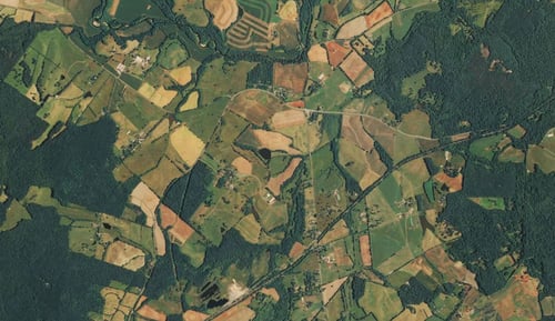
Farmland in Jefferson’s home state of Virginia, near Monticello. Irregularity reigns.


Ohio-Pennsylvania Border


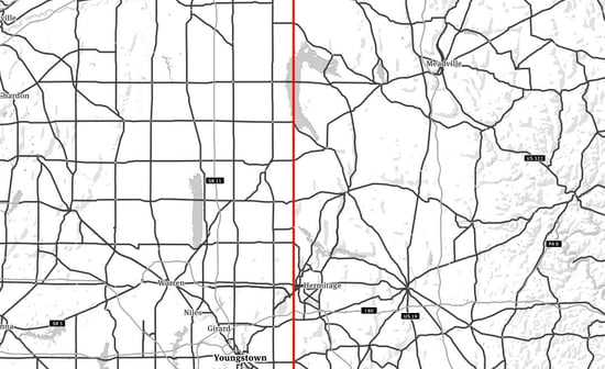
The border between northeast Ohio (left) and northwest Pennsylvania (right). Emphasizing secondary roadways, this map shows the influence of surveying methods based on the cardinal directions (Ohio) or lack thereof (Pennsylvania).

Kansas Sections

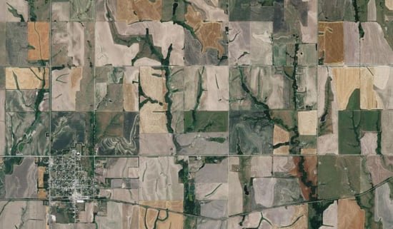
The landscape near Lebanon, KS (bottom left), the geographic center of the contiguous 48 states. Most visible are quarter sections, half a mile on a side and 160 acres - a quarter of one square-mile section. Different plantings and roads along section lines make these regular units especially clear.


Los Angeles Streets

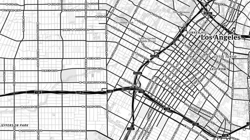
A street map of Los Angeles, reveals a stark difference between lands that were subject to the survey (conducted in the 1850s) and those that were not. Downtown (on the right) retains the grid of the original Spanish pueblo, while the streets to the west are oriented according to the baselines and meridians of the Public Land Survey System.

So next time you hop on a plane, grab a window seat and see if the legacy of the land survey shows through below.

(Sources: Mapbox, Openstreetmap, kcet.com)


Have questions? Want to evaluate our dataset? Get in touch with our team at parcels@regrid.com. 


Learn more about our Nationwide Parcel Data, our schema, pricing and coverage here.

About Regrid

Regrid is an industry-leading property data and location intelligence company. We serve an array of industries that require land parcels and spatial data at scale, including real estate, insurance, energy, infrastructure, agriculture, logistics, and government.

Previous Next
logo

(888) 4RE-GRID

  • Contact Us
  • Customer Support
  • Privacy Policy
  • Terms of Use

Subscribe for email updates

Company

  • About Regrid
  • Careers
  • Press

Resources

  • Coverage Map
  • Support Center
  • Reports
  • Regrid Status Page

Enterprise Solutions

  • U.S. Parcels
  • Canada Parcels
  • Parcel & Tiles API

Self-Serve Solutions

  • Regrid Property App
  • Shop the Data Store
  • API Monthly Plans