regrid_tm_forest
Sign In
  • Products

    Regrid premium parcel data menu icon Premium parcels

    • US Parcel Data U.S. parcels
    • global-icon Global parcels
    • Canada Parcel Data Canadian parcels
    • Europe-icon-navigation European parcels
    • map-location-pin-regrid-icon View the U.S. coverage map

    Spatial add-ons menu icon Spatial add-ons

    • Matched building footprints menu icon Matched building footprints
    • Matched secondary addresses menu icon Matched secondary addresses
    • Standardized zoning menu icon Standardized zoning
    • Enhanced property ownership menu icon Daily ownership updates
    • roadway-row-icon_2025-1 U.S. roadway polygons

    Data access icon Delivery methods

    • Bulk files icon Bulk files
    • Feature Service Feature service
    • api-icon_2025 Parcel API and tiles
    • API Sandbox icon Interactive API sandbox
  • Industries

    industries-we-serve Industries we serve

    • aec-navigation-icon Architecture, engineering, and construction (AEC)
    • re-navigation-icon Real estate
    • gov-navigation-icon Government
    • ag-navigation-icon Agriculture
    • energy-navigation-icon Renewable energy and utilities
    • telco-navigation-icon Broadband and telecommunications
    • insurance-navigation-icon Insurance and finance
    • ai-ml-navigation-icon AI and machine learning
    • transportation-navigation-icon Transportation and logistics
  • Data store
  • Regrid Property App
  • Esri users
  • Resources

    Support menu icon Support

    • Support site menu icon Support site
    • Tutorial videos menu icon Tutorial videos
    • blog_resources_icon-1 Parcel schema
    • Regrid icon Sign into the Regrid Property App

    Content menu icon Content

    • Blog menu icon Blog
    • Customer stories menu icon Customer Stories
    • Reports menu icon Reports
    • data-store-2 Coverage map

    Programs menu icon Programs

    • academia_menu-icon Nonprofit & Academia
    • Regrid giving menu icon Regrid Giving
    • dwp-navigation-icon copy Data with Purpose

    shop icon Shop

    • merch_icon_2025 Regrid Merch
  • Contact us
Contact us
  • Products

    Premium parcels

    • U.S. parcels
    • Global parcels
    • Canadian parcels
    • European parcels
    • View the U.S. coverage map

    Delivery methods

    • Bulk files
    • Feature service
    • Parcel API and tiles
    • Interactive API sandbox

    Spatial add-ons

    • Matched building footprints
    • Matched secondary addresses
    • Standardized zoning
    • Daily ownership updates
    • U.S. roadway polygons
  • Industries

    Industries we serve

    • Architecture, engineering, and construction (AEC)
    • Real estate
    • Government
    • Agriculture
    • Renewable energy and utilities
    • Broadband and telecommunications
    • Insurance and finance
    • AI and machine learning
    • Transportation and logistics
  • Data store
  • Regrid Property App
  • Esri users
  • Resources

    Support

    • Support site
    • Tutorial videos
    • Parcel schema
    • Sign into the Regrid Property App

    Programs

    • Nonprofit & Academia
    • Regrid Giving
    • Data with Purpose

    Content

    • Blog
    • Customer Stories
    • Reports
    • Coverage map

    Shop

    • Regrid Merch
  • Contact us

The Regrid Blog

Discover the Latest in Land Parcels & Spatial Data with the Regrid Team!

Categories

  • Announcements
  • Parcel Data Updates
  • Democratizing Data
  • Regrid Updates
  • Product How-To
  • Use Cases
  • All About Parcel Data
  • Customer & Guest Blogs
  • Working at Regrid
  • Regrid 100
  • Reports

A SCHOOL DISTRICT IN CRISIS: Detroit’s Public Schools 1842-2015

Jerry Paffendorf January 24, 2016
For Immediate Release: A Highly Visual Look at Detroit Public Schools From 1842-2015


A brand new report called A SCHOOL DISTRICT IN CRISIS: Detroit’s Public Schools 1842-2015, by Detroit-based mapping company LOVELAND Technologies, is now available at detroitschoolsreport.com.


A School District in Crisis, Detroit's Public Schools 1842-2015


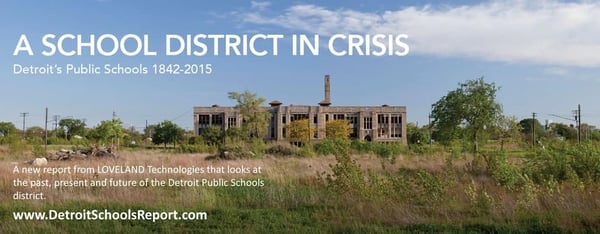
It is a highly visual, very readable, deeply comprehensive look at Detroit Public Schools since its beginning, told in pictures, maps, stats, and common language.


Infographic about Detroit public schools since the 1960s


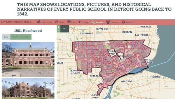
Included in the report are hundreds of new photographs taken by LOVELAND surveyors who visited every single DPS property, rare historic photographs mined from archives, an interactive map of all 470+ Detroit public schools that have ever existed since 1842, and an even-handed narrative about issues the school system has faced throughout its history.


Map of every school going back to 1842


As DPS teachers protest poor school conditions, and as the eyes of the world turn to Michigan trying to understand the impact of our Emergency Management laws, this report is a timely primer on where DPS came from, how it evolved, and where it currently stands, financially, physically, and socially.


It is designed to be readable by and informative to the general public, teachers, students, and policy makers.


A changing academic landscape.


The report is the result of more than a year and a half of independent research and surveying by LOVELAND Technologies. All of the content is being made freely available, and to cover costs, LOVELAND is inviting readers to pay what they want, hoping to raise $25,000 from people paying as little as $1.


Consequences after closing.


Please feel free to link to the report, use images, pull quotes, or remix the content however you would like, with a link back detroitschoolsreport.com and an attribution to LOVELAND Technologies.


For questions please email team@makeloveland.com or call 313-338-3825.


Thank you very much,


Team LOVELAND


LOVELAND Technologies

makeloveland.com

1514 Washington Blvd, Suite 201

Detroit, MI 48226

Previous Next
logo

(888) 4RE-GRID

  • Contact Us
  • Customer Support
  • Privacy Policy
  • Terms of Use
  • Cookie Preferences

Subscribe for email updates

Company

  • About Regrid
  • Careers
  • Press
  • Shop Regrid Merch

Resources

  • Coverage Map
  • Support Center
  • Reports
  • Regrid Status Page

Enterprise Solutions

  • U.S. Parcels
  • Canada Parcels
  • Parcel & Tiles API
  • Roadway Right-of-Way

Self-Serve Solutions

  • Regrid Property App
  • Shop the Data Store
  • API Monthly Plans