regrid_tm_forest
Sign In
  • Products ⌄

    Regrid premium parcel data menu icon Premium parcels

    • global-icon Global parcels
    • US Parcel Data U.S. parcels
    • Europe-icon-navigation European parcels
    • Canada Parcel Data Canadian parcels
    • map-location-pin-regrid-icon U.S. coverage map

    Spatial add-ons menu icon Spatial add-ons

    • Matched building footprints menu icon Matched building footprints
    • Matched secondary addresses menu icon Matched secondary addresses
    • Standardized zoning menu icon Standardized zoning
    • Enhanced property ownership menu icon Daily ownership updates
    • roadway-row-icon_2025-1 U.S. roadway polygons

    Data access icon Delivery methods

    • Bulk files icon Bulk files
    • Feature Service Feature service
    • api-icon_2025 Parcel API and tiles
    • API Sandbox icon Interactive API sandbox
  • Industries ⌄

    industries-we-serve Industries we serve

    • aec-navigation-icon Architecture, engineering, and construction (AEC)
    • re-navigation-icon Real estate
    • gov-navigation-icon Government
    • ag-navigation-icon Agriculture
    • energy-navigation-icon Renewable energy and utilities
    • telco-navigation-icon Broadband and telecommunications
    • insurance-navigation-icon Insurance and finance
    • ai-ml-navigation-icon AI and machine learning
    • transportation-navigation-icon Transportation and logistics
  • Data store
  • Property App
  • Esri users
  • Resources ⌄

    Support menu icon Support

    • Support site menu icon Support site
    • Tutorial videos menu icon Tutorial videos
    • blog_resources_icon-1 Parcel schema
    • Regrid icon Sign into the Regrid Property App

    Content menu icon Content

    • Blog menu icon Blog
    • Customer stories menu icon Customer Stories
    • Reports menu icon Reports
    • data-store-2 Coverage map

    Programs menu icon Programs

    • academia_menu-icon Nonprofit & Academia
    • Regrid giving menu icon Regrid Giving
    • dwp-navigation-icon copy Data with Purpose

    shop icon Shop

    • merch_icon_2025 Regrid Merch
  • Contact us
Contact us
  • Products ⌄

    Premium parcels

    • Global parcels
    • U.S. parcels
    • European parcels
    • Canadian parcels
    • U.S. coverage map

    Delivery methods

    • Bulk files
    • Feature service
    • Parcel API and tiles
    • Interactive API sandbox

    Spatial add-ons

    • Matched building footprints
    • Matched secondary addresses
    • Standardized zoning
    • Daily ownership updates
    • U.S. roadway polygons
  • Industries ⌄

    Industries we serve

    • Architecture, engineering, and construction (AEC)
    • Real estate
    • Government
    • Agriculture
    • Renewable energy and utilities
    • Broadband and telecommunications
    • Insurance and finance
    • AI and machine learning
    • Transportation and logistics
  • Data store
  • Property App
  • Esri users
  • Resources ⌄

    Support

    • Support site
    • Tutorial videos
    • Parcel schema
    • Sign into the Regrid Property App

    Programs

    • Nonprofit & Academia
    • Regrid Giving
    • Data with Purpose

    Content

    • Blog
    • Customer Stories
    • Reports
    • Coverage map

    Shop

    • Regrid Merch
  • Contact us

The Regrid Blog

Discover the Latest in Land Parcels & Spatial Data with the Regrid Team!

Categories

  • Announcements
  • Parcel Data Updates
  • Democratizing Data
  • Regrid Updates
  • Product How-To
  • Use Cases
  • All About Parcel Data
  • Customer & Guest Blogs
  • Working at Regrid
  • Regrid 100
  • Reports

Tax Foreclosure & Vacant Homes on Detroit's Maiden Street

Alex Alsup August 12, 2016

Northeast end of 11200 Block of Maiden Street, 2010 vs. 2016. Drag slider to see change.

I've kept track of the neighborhood around the shuttered Alexander Macomb Elementary School on Detroit's east side for a few years now, since I surveyed the area using Google Street View Time Machine imagery in this Loveland blog post. One block in particular has kept my attention:

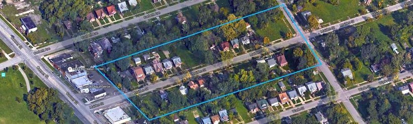
11200 block of Maiden Street, between Conner and Gunston

11200 Block of Maiden St, between Conner and Gunston

In 2014, after surveying the block with a combination of Google Street View Time Machine imagery and in-person surveys using Loveland's Site Control, I created a chart that showed the number of occupied vs. vacant homes vs. tax foreclosures on Maiden's 11200 block between 2008 and 2014. It was, I thought, a useful demonstration of the fact that where there is tax foreclosure, there will be vacant homes and, thus, declining population, declining tax revenue, and increasing blight.

Last week, on August 11th, 2016, I went back out to the 11200 block to resurvey the street and see how things had changed since my last visit, and to add another frame to the chart tracking vacancy and foreclosure.

I resurveyed the 34 properties on the block and found that the trajectory the street has followed since the financial crisis continues today. The chart below shows the number of occupied homes, vacant homes, and cumulative tax foreclosures on Maiden's 11200 block between August 2008 and August 2016:

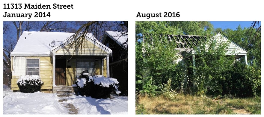
While there's not much left to go vacant, another property or two has emptied. Two of the properties that may still be occupied look squatted in -- one appeared to have drug activity outside it, and another was in rough shape and missing utility meters outside. Severe fires have caused the collapse of 2 additional structures since 2014, and significant damage to 5 others, like 11313 Maiden, seen here.

11313 Maiden St January 2014 vs 2016

The most notable change since 2014 is not the slight increase in vacancy or foreclosure, but the deterioration of property conditions on the block. The bar chart below compares the conditions of the 21 structures on Maiden Street as of January 2014, when the block was surveyed as part of Motor City Mapping, and when I resurveyed the street in August 2016:

The number of houses in "Poor" or "Suggest Demolition" condition doubled -- from 6 in 2014, to 12 in 2016. Houses in "Fair" or "Good" condition decreased from 15 in 2014, to 9 in 2016. There has been one demolition on the block since 2008.

As tax delinquency and foreclosure begets blight and vacancy, there is little evidence of a change of fortunes ahead for the 11200 block of Maiden Street: Of the 34 properties on the block, 22 are owned (via foreclosure) by the city or land bank, and 12 are still privately held. Of those 12 privately held, 8 are behind on their property taxes, and headed for foreclosure over the next couple years.

Put another way, of the 34 parcels on the 11200 block of Maiden Street, only 4 appear to be generating any property tax revenue.

If you'd like to explore the latest survey data, photography, and property conditions on Maiden Street, you can do so in the Site Control map below:

Previous Next
logo

(888) 4RE-GRID

  • Contact Us
  • Customer Support
  • Privacy Policy
  • Terms of Use
  • Cookie Preferences

Subscribe for email updates

Company

  • About Regrid
  • Careers
  • Press
  • Shop Regrid Merch

Resources

  • Coverage Map
  • Support Center
  • Reports
  • Regrid Status Page

Enterprise Solutions

  • U.S. Parcels
  • Canada Parcels
  • Parcel & Tiles API
  • Roadway Right-of-Way

Self-Serve Solutions

  • Regrid Property App
  • Shop the Data Store
  • API Monthly Plans