.svg)


Data With Purpose - End of Year Report 2022
Regrid has a long history of fighting for increased access to parcel data for nonprofits, public policy advocacy, and researchers & academics. We have deep roots in this space from our years of work in Detroit, Michigan, where the company was founded.
Last year we sought to build on and enshrine this spirit with the launch of our Data With Purpose program, which has grown considerably in 2022. Through Data With Purpose, Regrid seeks to make our parcel shapes & data more accessible to nonprofit organizations, researchers, academics, community organizations, and more.
We know how hard it can be to find quality parcel data for nonprofit use cases, so Data With Purpose offers Regrid’s data on a “pay what you can” basis and an open call for applications.
Nonprofit organizations, researchers, and academics can apply year-round to the Data With Purpose program here and can expect a response within days.
We also know how rare it is for these organizations to get decent service from parcel vendors, and we’ve dedicated ourselves to making sure every Regrid client gets excellent service.
.png?width=728&height=380&name=2022%20EoY%20Report%20-%20Blog%20Header%20(4).png)
DWP 2022 Case Studies -
The Trust for Public Land:
In 2022, the Trust for Public Land needed a new source of national parcel boundaries & data and applied to Data With Purpose. Regrid was excited to support one of the country’s largest land conservation nonprofits, The Trust for Public Land, to support its conservation efforts across the country. The Trust for Public Land is now using Regrid parcel data internally to help determine conservation priorities, based on carbon, wildlife habitat, and other factors
In the near future, the Trust for Public Land will also use Regrid data to support its Conservation Carbon Map, which helps users answer three key questions:
-
-
Where are existing forest carbon stocks and areas with high annual carbon sequestration rates?
-
What and where are the threats to these carbon-rich landscapes from development, insects, and disease, and wildfire risk?
-
Where can climate conservation also provide multiple co-benefits by protecting drinking water supplies, rare ecosystems, and important habitat cores?
-
Learn more about the Trust for Public Land and the Conservation Carbon Map
Michigan Geological Survey - The Triage Project:
When PFAS contamination concerns arise in Michigan, experts turn to the Michigan Department of Environment, Great Lakes and Energy’s Wellogic database. However, as the Michigan Geological Survey at Western Michigan University found as they began validating the state’s well water location data in 2019, nearly 40% of the well location data was inaccurate and the locations of more than 700,000 wells in the state were not digitized. Even when PFAS contamination was identified, it was difficult to know which wells were affected.
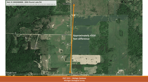
Image courtesy of MGS Triage Project showing example of recorded vs. actual well location
In the summer of 2022, the Triage Project applied to Data With Purpose. The Triage Project was eager to use Regrid’s brand new Esri-compatible Feature Service, which would make Regrid’s nationwide parcel data available to the Triage Project through ArcPro and ArcGIS Online.
Today, the Triage Project is building the Wellogic database faster than ever before and is able to respond to PFAS contamination concerns much faster, too. Said Evie Murgia, Project Manager of the Triage Project, “Previously, we had to manually and visually assess the plotted location of each individual well point. Now, we are able to process up to 60% of a given county’s well data using a Michigan Geological Survey-developed ArcPython script which depends on Regrid parcel data and Regrid’s Esri Feature Service. This has dramatically increased our productivity.”
Learn more about The Triage Project
Climate Central - Sinking Tax Base:
Coastal flooding caused by sea level rise is shifting the tide lines that many coastal states use to delineate boundaries between public and private property. Changes in property boundaries can have significant implications for both property owners and local property tax revenues—a primary source of funding for schools and services provided by local governments.
When Climate Central sought to quantify the projected losses in market value and property tax revenue across 250 coastal US counties in the coming decades, they applied to Data With Purpose. Equipped with Regrid’s parcel data, they published the groundbreaking report, Sinking Tax Base.
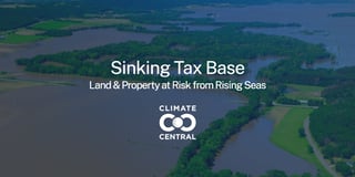
This analysis delivers an assessment of sea level rise impact on the tax base of hundreds of coastal U.S. counties—specifically, the potential loss of taxable properties caused by shifting tidal boundaries. Findings by the county are detailed in more than 250 reports and a national summary including data on the acreage, buildings, number of properties, and assessed value projected to be at risk this century, by decade.
Learn more about Climate Central & the Sinking Tax Base.
DWP 2022 Original Research & Analysis -
The Detroit Assessment Gauge:
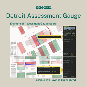
Regrid has long been involved in issues related to property tax assessments and foreclosure in Detroit and across the country. In 2022, Regrid sought to develop a way for Detroit residents to better understand if their home is overassessed, and proceed with an assessment appeal if it was.
The Detroit Assessment Gauge used 2022 assessment data from the City of Detroit’s Office of the Assessor as well as Regrid’s own land parcel data to evaluate privately owned single family homes in Detroit (about 70% of the city’s housing units) for one potential indication of overassessment: Inconsistent Assessments.
This freely available tool can be accessed by anyone interested in exploring single-family home assessments in Detroit, and Regrid is collecting interest from other cities across the country that want to see an Assessment Gauge for their community.
Regrid’s Data With Purpose is a non-profit organization and academia support program. Projects that directly assist communities or advance our shared understanding of land and geographies may apply to use our parcel data on a ‘pay what you can’ basis.
Please take a look at our Nationwide Parcel 2022 Data EoY Report and see how we are bringing location intelligence to a new level of data transparency.