×
Download now - The Regrid Property App (for iOS & Android)
Regrid TM Logo
  • Products

    Data

    • Nationwide Parcel Data Nationwide Parcel Data
    • Parcel API & Tiles Parcel API & Tiles
    • Parcels and Matched Building Footprints Parcels + Matched Building Footprints
    • addresses-menu-icon Parcels + Matched Secondary Addresses

    Self-Serve Tools

    • Property App Property App
    • Mapping Tools Self-Serve API Plans
    • Data Store Data Store
  • Use-Cases

    • featureservice-menuicon Feature Service
    • Real Estate Use Case page symbol Real Estate
    • renewables-usecase Renewable Energy
    • datascience-usecase Data Science
    • support-site_nav-1 Land Use Codes
    • blog_nav Vacancy
  • Resources

    Content

    • Regrid Blog Blog
    • Coverage Map Coverage Map
    • Reports Reports
    • Webcasts Webcasts

    Support

    • Support Site Support Site
    • Platform FAQ Platform FAQ
    • Parcel Data FAQ Parcel Data FAQ
    • Tutorial Videos Tutorial Videos

    Customers

    • Customer Stories Customer Stories
    • Case Studies Case Studies
    • Data with purpose logo Data With Purpose
Go to Map
  • Products

    Data

    • Nationwide Parcel Data Nationwide Parcel Data
    • Parcel API & Tiles Parcel API & Tiles
    • Parcels and Matched Building Footprints Parcels + Matched Building Footprints
    • addresses-menu-icon Parcels + Matched Secondary Addresses

    Self-Serve Tools

    • Property App Property App
    • Mapping Tools Self-Serve API Plans
    • Data Store Data Store
  • Use-Cases

    • featureservice-menuicon Feature Service
    • Real Estate Use Case page symbol Real Estate
    • renewables-usecase Renewable Energy
    • datascience-usecase Data Science
    • support-site_nav-1 Land Use Codes
    • blog_nav Vacancy
  • Resources

    Content

    • Regrid Blog Blog
    • Coverage Map Coverage Map
    • Reports Reports
    • Webcasts Webcasts

    Support

    • Support Site Support Site
    • Platform FAQ Platform FAQ
    • Parcel Data FAQ Parcel Data FAQ
    • Tutorial Videos Tutorial Videos

    Customers

    • Customer Stories Customer Stories
    • Case Studies Case Studies
    • Data with purpose logo Data With Purpose

Regrid Reports

Check out the official reports on customer property survey and data analyses projects using the Regrid Parcel Data

Contact an expert

Customer Stories

Categories

  • Reports

Weed in the D: A Windshield Survey of Medical Marijuana In Detroit

Larry Sheradon October 6, 2015
What this report covers

In 2008, Michigan voters approved an act that legalized the medical use of marijuana. Today over 96,000 people throughout the State of Michigan are registered patients, leading to the creation of a network of growers and "caregivers" who cultivate and sell medical marijuana, as well as retail locations known as dispensaries.


In October of 2015, Loveland Technologies began surveying all known medical marijuana dispensaries located along major commercial corridors in Detroit with the aim of determining how many dispensaries are active in the city and where they are located. This survey used a combination of online resources for finding dispensaries and canvasing of over 400 miles of commercial corridors to arrive at the conclusions.


Medical marijuana dispensaries have been opening across the City of Detroit. As the city does not currently have a formal regulatory process, the number and location of dispensaries is unclear, with estimates ranging from 50 to 180.


The numbers detailed in this report are by no means definitive; Even during the relatively short survey period dispensaries were opening days after a road had been surveyed. The clandestine nature of some dispensaries makes it difficult to identify them from the street. As a result, the number of dispensaries presented in this report is probably lower than the actual number.


Summary of findings:

152 Marijuana Dispensaries currently or recently operating in Detroit

103 (64%) Dispensaries are located within 1.15 miles of the suburbs of Detroit; High concentrations of marijuana dispensaries are located close to the suburbs, particularly Grosse Pointe Park, Eastpointe, Warren, Southfield, and Dearborn.

62 dispensaries are located within 1,000 feet of an active school.

59 schools have one or more dispensaries located within 1,000 feet.

16 schools have two or more dispensaries located within 1,000 feet.

9 high schools have a dispensary located within 1,000 feet.

Ford High School has 2 dispensaries within 1,000 feet. There are 14 dispensaries in the immediate vicinity of the school, mostly along the major commercial corridors. 


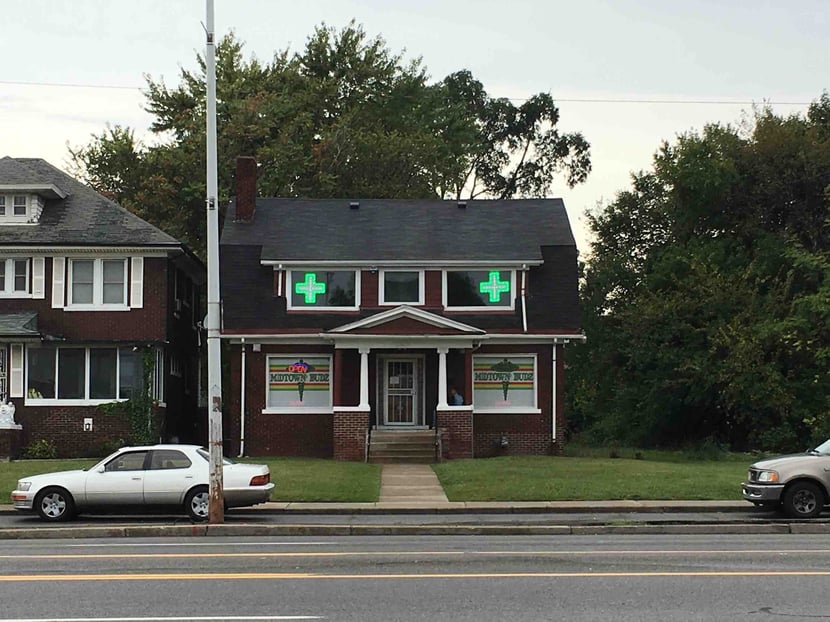
Marijuana dispensaries can be found in a variety of different types of commercial and residential structures. Dispensaries range from heavily advertised, with neon signs and advertisements, to low-profile offices with no outward indication of what is being sold there. Bank buildings, restaurants, storefronts, strip clubs, gas stations, and residential houses have all been converted into dispensaries...


Read the Full Report


Medical Marijuana Storefront in Detroit


Map of dispensaries in Detroit, MI
Explore the Map

Next
logo

help@regrid.com

(888) 4RE-GRID

440 Burroughs St, Suite 672 Detroit, MI 48202

Sign up for our email newsletter:

Regrid is a creation of Loveland Technologies and was formerly known as Landgrid

Company

  • About Us
  • Careers
  • Why Regrid?
  • Press

Resources

  • Blog
  • Tutorial Videos
  • Reports
  • Coverage Map

Customers

  • Customer Stories
  • Case Studies
  • Data With Purpose

Support

  • Guidebook
  • Parcel Data FAQ
  • Platform FAQ
  • Contact Us
  • Site Status

Products

  • Nationwide Parcel Data
  • Data Store
  • Parcel API & Tiles
  • Regrid Property App
  • Plans & Pricing
  • Matched Building Footprints
  • Matched Secondary Addresses
  • Regrid Feature Service