


.png)


.svg)


Announcing the Regrid Typeahead API & new Parcel API search parameters

In keeping with our mission to make land information easy to find and work with through our app and data products, we have a New Product Update - Regrid Typeahead API for those of you who use or want to use our API.
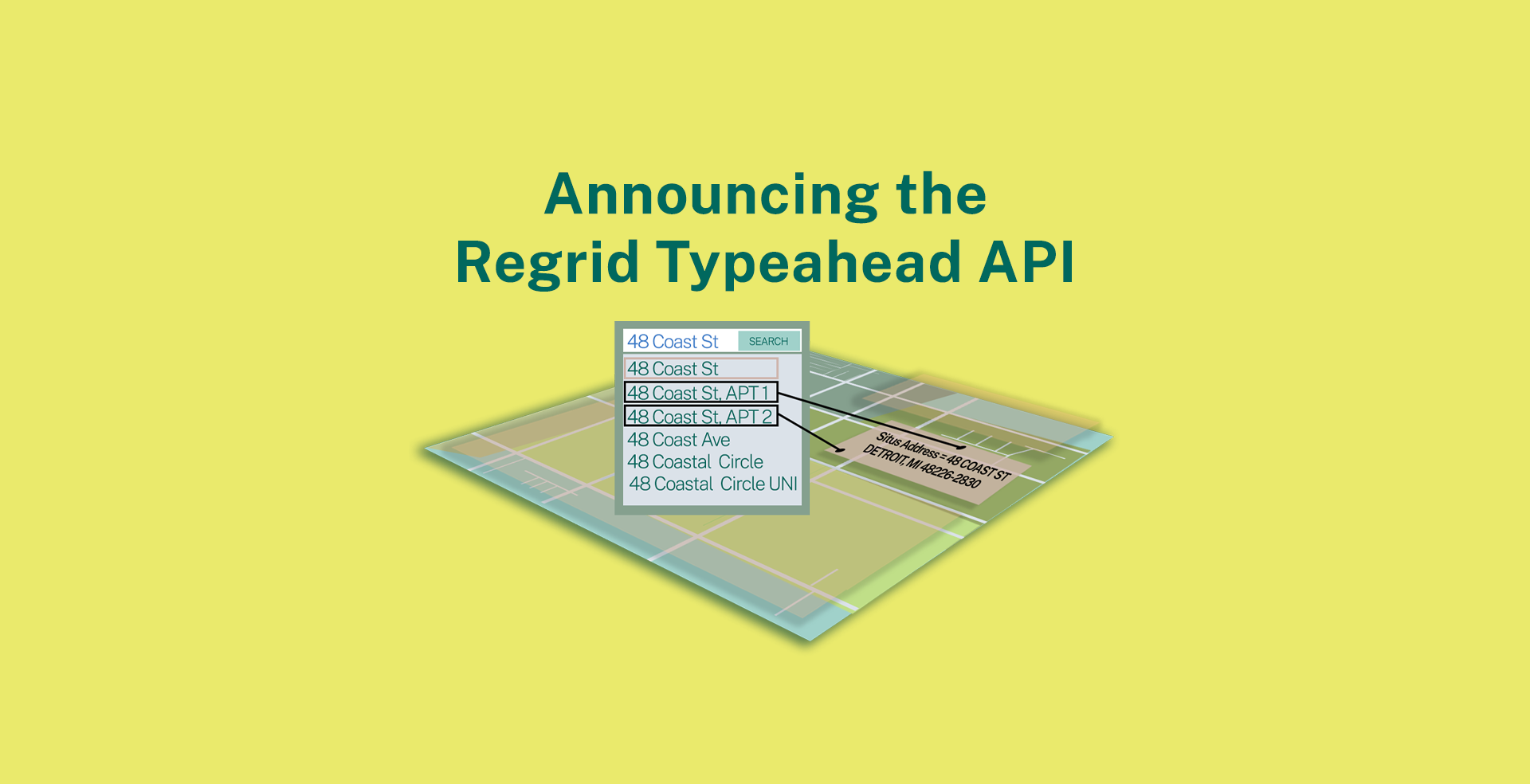
Look up 300M USPS verified, searchable addresses and find matching parcel records with the Regrid Typeahead Address Search.
If you are looking up incomplete or wonky addresses, we now have an easy to use Typeahead (also known as autocomplete) API that will return all matching complete, validated addresses, our universal parcel id and parcel centroids in seconds.
Feel free to integrate this API into your app or map and enable your own address autocomplete search UI.
Couple that with our robust & RESTFUL Parcel API to not only find validated, complete, cleaned up & USPS verified addresses but to reconcile these addresses with their matching parcel records.
With our Typeahead & Parcel API, you can look up 300M USPS verified, searchable addresses and find matching parcel records.
The complete use case from incomplete, invalidated addresses to high-quality parcel records and location data.
Location certainty at an unmatched price of $0.001 per request.
Learn more about using and integrating our Typeahead API.
If you already use our Parcel API & tiles and work with addresses, sometimes incomplete, non-USPS verified, then the Typeahead API will be the ideal complement to the Parcel API.
Reach out to us at parcels@regrid.com and we can get you set up with Typeahead.
If you are interested in our API solutions - Parcel records look up, address look up (typeahead) and our tileserver, no better time to reach out to us to stream our high-quality parcels & addresses into your technical stack.

New Parcel API Search Updates
We are not done yet with our Parcel API updates.
Apart from improving the overall quality & performance of our Parcel API & coupling it with our new autocomplete typeahead API, we have now made our Parcel API searchable at a nationwide level with many more, highly requested and relevant fields from our parcel schema.
The API was already searchable by Parcel ID (APN), lat/lon, address, UUID, polygon and owner name.
With this new update, the Parcel API is now searchable by the following fields in the Regrid Parcel Schema:
- ll_gisacre - Parcel acreage as calculated by the Regrid team from the parcel geometry
- usps_vacancy - USPS vacancy indicator
- rdi - residential delivery indicator
- ll_bldg_count - buildings count per parcel
- lbcs_activity - Land use code - Activity. The actual activity on land - example farming, shopping
- lbcs_function - Land use code - Function. Economic function or type of establishment, eg agricultural, commercial, industrial
- lbcs_structure - Land use code - Structure. Type of structure or building, eg single-family house, office building, warehouse
- lbcs_site - Land use code - Site. The physical characteristics of what is on land.
- lbcs_ownership - Land use code - Ownership. Ownership structure, eg public, private
- saleprice - Last sale price
- saledate - Last sale date of the property
- zoning - Zoning code, Varies by governing municipality. Examples: R-1
- landval - Land value
- scity - Situs address city
- state2 - Situs address state
To understand the search operators for these fields and how to use our API, review our API documentation here.
With these improvements, we’ve raised the bar when it comes to the use cases our API can now serve at a greater granular level - from site selection via a query on the acreage field to getting a deeper understanding of property data through normalized land use codes and buildings count to so much more.
All at an uptime of 99.95%.
Don’t believe us? Hear from our partners at GravityJack who recently used our API to build us an Augmented reality (AR) property data & look up app.

Reach out to us to get a sample API token to evaluate if our API is right for your needs.
Another big product launch is coming up shortly.
So stay tuned with us.
Until next time,

