Regrid logo, registered trademark
  • Enterprise Solutions

    Regrid parcel data Regrid Parcel Data

    Bulk files delivered in the format your business needs.

    • parcel -data Nationwide Parcel Data
    • matched building footprints menu icon Matched Building Footprints
    • matched secondary addresses menu icon Matched Secondary Addresses
    • enhanced ownership menu icon Enhanced Ownership

    feature service menu icon Regrid Feature Service

    Get data delivery straight into your Esri-stack, no custom integration required.

    regrid api menu icon Regrid API

    Integrate parcel boundaries & records into your app, SaaS, or map.
    • Parcel and Tiles APIcon Parcel & Tiles API
    • typeahead api icon Typeahead API
  • Self Serve Options

    Regrid Property App menu icon Regrid Property App

    Take Regrid property data wherever you go - available for web, iOS, & Android.

    data-store-2 Shop the Data Store

    Instantly download parcel geometries & associated records, by county and state.

    self-serve parcel api menu icon API Monthly Subscriptions

    Sign up and try this nationwide parcel API, free for 7 days.

    api sandbox icon Interactive API Sandbox

    Explore the API Sandbox with complete feature access to 7 counties plus Puerto Rico.
  • Markets

    Regrid for Broadband Market Broadband

    Regrid for data science Data Science

    Esri environments Esri Users

    Parcel data for green initiatives Sustainable Initiatives

    Parcel data for real estate Real Estate

    Parcel data for nonprofit and academia Nonprofit & Academia

    Regrid's Data With Purpose program - propose your own budget to access land parcel data. 

    Plus sign icon Your Business or Organization

    Regrid’s data spans all industries needing land insight.
  • Resources

    support menu icon Support

    Access documentation & support materials to learn about Regrid data.
    • Support site resource icon Support Site
    • tutorial videos resources icon Tutorial Videos
    • parcel data faqs resources icon Parcel Data FAQs
    • property app faqs Property App FAQs
    • coveragemap_resources_icon Coverage Map
    • land use codes menu item Land Use Codes
    • vacancy data menu icon Vacancy Data

    content resources menu icon Content

    Dive into Regrid's world of land parcels & learn about location intelligence.
    • blog resources icon Blog
    • webcasts resources icon Webcasts
    • reports resources icon Reports
    • podcast resources icon Living In The Map

    customers resources icon Customers

    Hear what our customers say have to say & see how they use Regrid data.
    • testimonials resources icon Testimonials
    • Case Studies resources icon Case Studies
  • Contact Us

    Contact a parcel data expert menu icon Contact A Parcel Data Expert

    Contact Regrid parcel data experts to learn more about our offerings.

    Customer Support menu icon Customer Support

    Contact our customer support team & get the help you need.

    megamenu nav image Press & Media Inquires

    Find the information you need & get in touch with our marketing department.
  • Go To Map
Go To Map
  • Enterprise Solutions

    Regrid Parcel Data

    • Nationwide Parcel Data
    • Matched Building Footprints
    • Matched Secondary Addresses
    • Enhanced Ownership

    Regrid Feature Service

    Regrid API

    • Parcel & Tiles API
    • Typeahead API
  • Self Serve Options

    Regrid Property App

    Shop the Data Store

    API Monthly Subscriptions

    Interactive API Sandbox

  • Markets

    Broadband

    Data Science

    Esri Users

    Sustainable Initiatives

    Real Estate

    Nonprofit & Academia

    Your Business or Organization

  • Resources

    Support

    • Support Site
    • Tutorial Videos
    • Parcel Data FAQs
    • Property App FAQs
    • Coverage Map
    • Land Use Codes
    • Vacancy Data

    Content

    • Blog
    • Webcasts
    • Reports
    • Living In The Map

    Customers

    • Testimonials
    • Case Studies
  • Contact Us

    Contact A Parcel Data Expert

    Customer Support

    Press & Media Inquires

  • Go To Map

The Regrid Blog

Discover the Latest in Land Parcels & Spatial Data with the Regrid Team!

Regrid Blog

Living In The Map

Categories

  • Announcements
  • Democratizing Data
  • Regrid Updates
  • Parcel Data Updates
  • Product How-To
  • Use Cases
  • Customer & Guest Blogs
  • All About Parcel Data
  • Working at Regrid
ask chatgpt banner

Introducing “Ask ChatGPT” in The Regrid Property App

Jerry Paffendorf August 23, 2023

“Nature is a language, can't you read? 

So ask me, ask me, ask me 

Ask me, ask me, ask me” 

– The Smiths, Ask


Regrid CEO, Jerry Paffendorf here with a fun announcement: our first ChatGPT integration is now live in The Regrid Property App for Apple and Android.


Ask ChatGPT” is a convenient new way to learn about the social, natural, economic, and historic contexts of places alongside Regrid’s comprehensive land and property information.


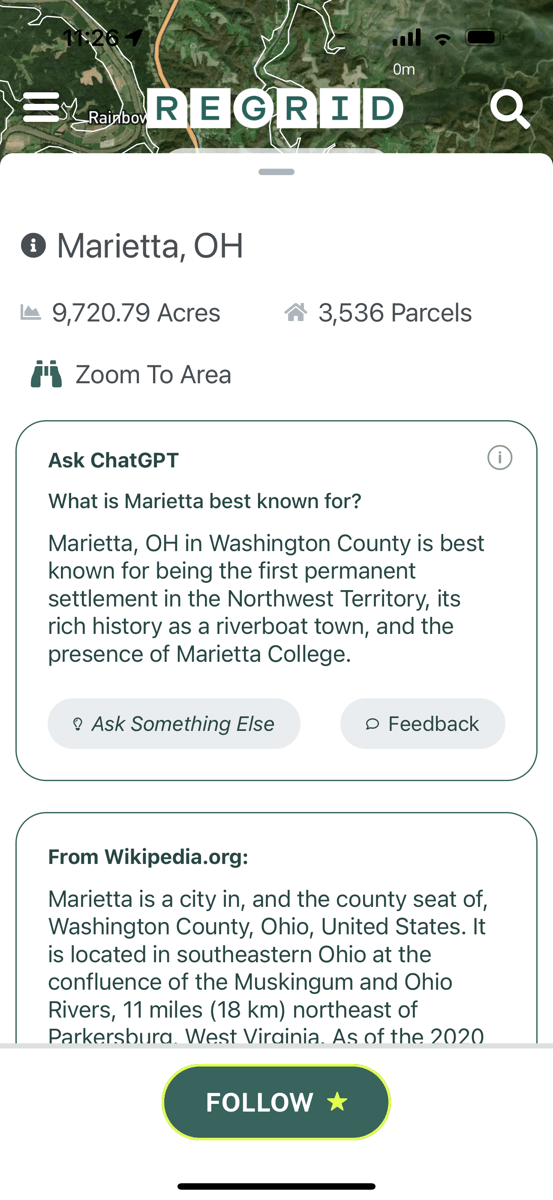
Simply tap the place name at the top of the map and you’ll see a box telling you what the community you’re looking at is best known for. Tap “Ask Something Else” and a gallery of 10 tappable questions will appear. Everyone can see the first answer for every community in the country, and Pro users can keep tapping until your heart’s content.

To clearly illustrate, here’s what every question and answer looks like in Marietta, Ohio (I’ll explain why I picked Marietta below):


2-3
1-4
3-3
4
5
6
7
8
9
10
11


“Ask ChatGPT” builds on the expanded place context we provide through Wikipedia and Native Lands integrations, which are also accessible in the same section of the app. I’m fond of saying “land is more than real estate,” and truly appreciate these convenient ways to learn about communities.


Look out for more integrations like this as we continue making the Regrid app the best land and property teacher as well as the best land and property data service.


Now briefly back to Marietta and some of the motivation here:


While I was donating money to friends at a recent poker night in Detroit, one of them gave me a copy of a book called The Pioneers: The Heroic Story of the Settlers Who Brought the American Ideal West, by David McCullough. (Clearly we get wild at poker night.)


It tells the story of Marietta, the first permanent US settlement in Ohio, founded in 1788. Some of the settlers had been authors of the Northwest Ordinance, which set the rules for what would become Ohio, Michigan, Indiana, Illinois, Wisconsin, and Minnesota – including prohibiting slavery in this expansion of the United States, and promising to set aside land and funding for public education.


As I read about the community clearing land, building the first houses and schools, planting crops, and identifying and protecting Native burial mounds, I found myself opening The Regrid Property App to find those properties and look at the land today.


I was able to, and it was helpful for context – ‘Hey, there’s the island parcel where sketchy former Vice President William Burr stayed with that odd family in their weird house while he was conspiring to seize a portion of Mexico before he was arrested on charges of treason; same as it ever was’ – but I wanted more than just the property boundaries, measurements, and current assessment information to bring the story of the land to life. I wanted the app to assist me in understanding more about that place.


While ChatGPT isn’t perfect, I was delighted to see it surface pointers to some of the things that I read about in the book. Properties and places are all made of stories and compelling human and natural situations, but that’s all lost until they come to life for us in some way. 


We’ve been encouraged by the results of this approach so far, and hope you enjoy our first steps into adding more educational context in The Regrid Property App. Note that we will always label any use of ChatGPT and other AI tools in our app, and provide appropriate disclaimers that they are not reviewed by humans and may be inaccurate. You’ll also find a feedback button next to every answer so you can let us know what you think of specific answers or the feature in general.


Please take “Ask ChatGPT” for a spin, try it in your own community, use it on the go, and let us know what you think!

Previous Next
logo

(888) 4RE-GRID

  • Contact Us
  • Customer Support
  • Privacy Policy
  • Terms of Use

Subscribe for email updates

Company

  • About Regrid
  • Careers
  • Press

Resources

  • Coverage Map
  • Support Center
  • Reports

Support

  • Parcel Data FAQs
  • Property App FAQs
  • Contact Support Team

Customers

  • Customer Stories
  • Case Studies
  • Non Profit & Academia

Enterprise Solutions

  • Nationwide Land Parcels
  • Parcel & Tiles API
  • Feature Service

Self-Serve Solutions

  • Regrid Property App
  • Shop the Data Store
  • API Monthly Plans