Regrid logo, registered trademark
  • Enterprise

    Regrid premium parcel data menu icon Premium Parcels

    • US Parcel Data U.S. Parcels
    • Canada Parcel Data Canadian Parcels
    • global-icon Global Parcels

    Spatial add-ons menu icon Spatial Add-Ons

    • Matched building footprints menu icon Matched Building Footprints
    • Matched secondary addresses menu icon Matched Secondary Addresses
    • Standardized zoning menu icon Standardized Zoning
    • Enhanced property ownership menu icon Daily Ownership Updates

    road icon Roadway ROW

    • Roadway polygons icon U.S. Roadway Polygons

    Data access icon Data Access

    • data-store-2 Coverage Map
    • blog_resources_icon-1 Parcel Schema
    • Bulk files icon Bulk Files
    • Feature Service Feature Service
    • api-icon_2025 Parcel API & Tiles
    • API Sandbox icon Interactive API Sandbox
  • Data Store
  • Regrid App
  • Esri Users
  • Resources

    Support menu icon Support

    • Support site menu icon Support Site
    • Tutorial videos menu icon Tutorial Videos

    Content menu icon Content

    • Blog menu icon Blog
    • Customer stories menu icon Customer Stories
    • Reports menu icon Reports

    Programs menu icon Programs

    • academia_menu-icon Nonprofit & Academia
    • Regrid giving menu icon Regrid Giving
  • Contact Us
Contact Us
  • Enterprise

    Premium Parcels

    • U.S. Parcels
    • Canadian Parcels
    • Global Parcels

    Roadway ROW

    • U.S. Roadway Polygons

    Spatial Add-Ons

    • Matched Building Footprints
    • Matched Secondary Addresses
    • Standardized Zoning
    • Daily Ownership Updates

    Data Access

    • Coverage Map
    • Parcel Schema
    • Bulk Files
    • Feature Service
    • Parcel API & Tiles
    • Interactive API Sandbox
  • Data Store
  • Regrid App
  • Esri Users
  • Resources

    Support

    • Support Site
    • Tutorial Videos

    Programs

    • Nonprofit & Academia
    • Regrid Giving

    Content

    • Blog
    • Customer Stories
    • Reports
  • Contact Us

The Regrid Blog

Discover the Latest in Land Parcels & Spatial Data with the Regrid Team!

Regrid Blog

Living In The Map

Categories

  • Announcements
  • Parcel Data Updates
  • Democratizing Data
  • Regrid Updates
  • Product How-To
  • Use Cases
  • Customer & Guest Blogs
  • All About Parcel Data
  • Working at Regrid
  • Regrid 100
  • Reports

New Updates for Pro and Enterprise accounts, and for Counties!

Jerry Paffendorf February 20, 2019

We're so excited about the reaction to the new landgrid.com site. One of the benefits is that it's much easier for us to provide more account features to meet your needs.

Here's a short list of what's new in February for our different user and customer levels:

Pro Account Updates

• Pro accounts will now find they can use a distance and area measuring tool under the Draw tool.

Measure tool on Regrid saas platform


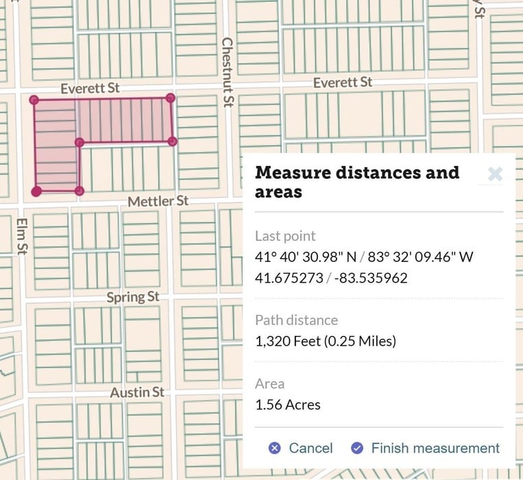
Soon you will also find an easy way to export your maps as images with a title and legend so you can drop it right into a report, presentation, or webpage with no hassle. New map layers are also on their way.

If you don't have a Pro account, signup for only $10/month or $100/year at landgrid.com/plans.


Enterprise Account Updates

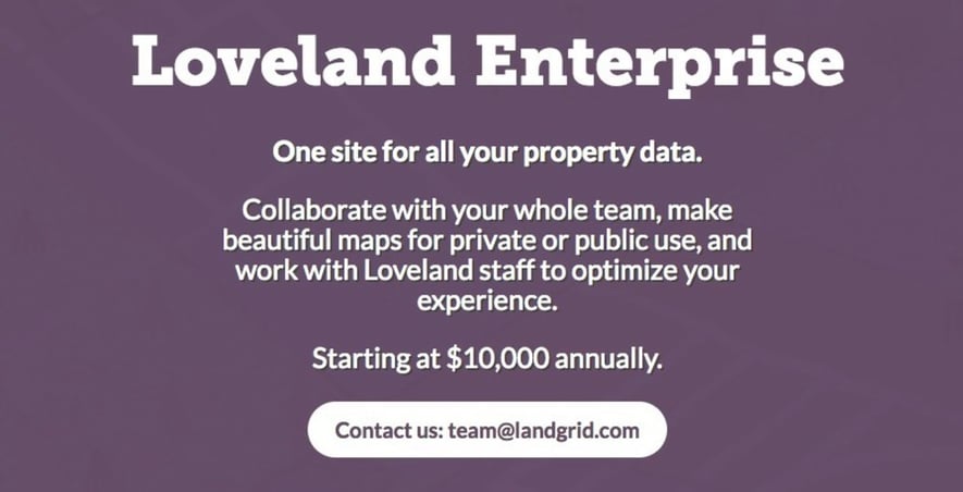
• Enterprise accounts now include us importing your data into your account for you, as well as providing you with an account manager. There's a brand new Enterprise brochure page at landgrid.com/enterprise.

If your organization wants to see and manage its property information in an easier way, this is for you. Enterprise accounts are $10,000/year and we have room to add about 10 more this year. Claim your spot.

Loveland Enterprise starting at $10,000 annually


County Updates

• In addition to our nationwide parcel licenses we are now offering raw data for individual counties for only $200, and we'll coach you on getting it into the right format for your needs.

If you only need a handful of counties for your app and are having trouble working with the source data, this is a great option for you. Learn more at landgrid.com/parcels and get in touch at parcels@landgrid.com.

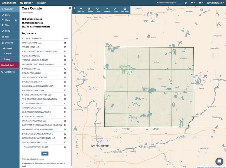
• Lastly, we've had counties approaching us about being their official parcel data viewer. If you or someone you love is a county (or in some cases a city) who would like to serve parcel data directly into the Land Grid so that you can provide high-quality parcel data to the public without paying for an expensive standalone parcel viewer, our team will work with you to set that up for no charge as we are currently doing in Cass County, Michigan: landgrid.com/us/mi/cass.

Cass County, MI


Thank you and enjoy the service from the Loveland Technologies team! As always you can reach us at team@landgrid.com.

Previous Next
logo

(888) 4RE-GRID

  • Contact Us
  • Customer Support
  • Privacy Policy
  • Terms of Use

Subscribe for email updates

Company

  • About Regrid
  • Careers
  • Press

Resources

  • Coverage Map
  • Support Center
  • Reports
  • Regrid Status Page

Enterprise Solutions

  • U.S. Parcels
  • Canada Parcels
  • Parcel & Tiles API

Self-Serve Solutions

  • Regrid Property App
  • Shop the Data Store
  • API Monthly Plans