regrid_tm_forest
Sign In
  • Products

    Regrid premium parcel data menu icon Premium parcels

    • US Parcel Data U.S. parcels
    • global-icon Global parcels
    • Canada Parcel Data Canadian parcels
    • Europe-icon-navigation European parcels
    • map-location-pin-regrid-icon View the U.S. coverage map

    Spatial add-ons menu icon Spatial add-ons

    • Matched building footprints menu icon Matched building footprints
    • Matched secondary addresses menu icon Matched secondary addresses
    • Standardized zoning menu icon Standardized zoning
    • Enhanced property ownership menu icon Daily ownership updates
    • roadway-row-icon_2025-1 U.S. roadway polygons

    Data access icon Delivery methods

    • Bulk files icon Bulk files
    • Feature Service Feature service
    • api-icon_2025 Parcel API and tiles
    • API Sandbox icon Interactive API sandbox
  • Industries

    industries-we-serve Industries we serve

    • aec-navigation-icon Architecture, engineering, and construction (AEC)
    • re-navigation-icon Real estate
    • gov-navigation-icon Government
    • ag-navigation-icon Agriculture
    • energy-navigation-icon Renewable energy and utilities
    • telco-navigation-icon Broadband and telecommunications
    • insurance-navigation-icon Insurance and finance
    • ai-ml-navigation-icon AI and machine learning
    • transportation-navigation-icon Transportation and logistics
  • Data store
  • Regrid Property App
  • Esri users
  • Resources

    Support menu icon Support

    • Support site menu icon Support site
    • Tutorial videos menu icon Tutorial videos
    • blog_resources_icon-1 Parcel schema
    • Regrid icon Sign into the Regrid Property App

    Content menu icon Content

    • Blog menu icon Blog
    • Customer stories menu icon Customer Stories
    • Reports menu icon Reports
    • data-store-2 Coverage map

    Programs menu icon Programs

    • academia_menu-icon Nonprofit & Academia
    • Regrid giving menu icon Regrid Giving

    shop icon Shop

    • merch_icon_2025 Regrid Merch
  • Contact Us
Contact Us
  • Products

    Premium parcels

    • U.S. parcels
    • Global parcels
    • Canadian parcels
    • European parcels
    • View the U.S. coverage map

    Delivery methods

    • Bulk files
    • Feature service
    • Parcel API and tiles
    • Interactive API sandbox

    Spatial add-ons

    • Matched building footprints
    • Matched secondary addresses
    • Standardized zoning
    • Daily ownership updates
    • U.S. roadway polygons
  • Industries

    Industries we serve

    • Architecture, engineering, and construction (AEC)
    • Real estate
    • Government
    • Agriculture
    • Renewable energy and utilities
    • Broadband and telecommunications
    • Insurance and finance
    • AI and machine learning
    • Transportation and logistics
  • Data store
  • Regrid Property App
  • Esri users
  • Resources

    Support

    • Support site
    • Tutorial videos
    • Parcel schema
    • Sign into the Regrid Property App

    Programs

    • Nonprofit & Academia
    • Regrid Giving

    Content

    • Blog
    • Customer Stories
    • Reports
    • Coverage map

    Shop

    • Regrid Merch
  • Contact Us

The Regrid Blog

Discover the Latest in Land Parcels & Spatial Data with the Regrid Team!

Categories

  • Announcements
  • Parcel Data Updates
  • Democratizing Data
  • Regrid Updates
  • Product How-To
  • Use Cases
  • All About Parcel Data
  • Customer & Guest Blogs
  • Working at Regrid
  • Regrid 100
  • Reports

New Features for Pro accounts: Census Data, Layers, and a Survey

Nick March 14, 2019

New Premium Features on Loveland Pro Accounts

Just a few quick updates from the Loveland team today: we have rolled out a couple of new features for all of our paid accounts and we're excited to share them with you! Our data team is always working to bring you the latest and greatest in parcel data. As always, if you need something or run into any issues feel free to reach out to our team at parcels@regrid.com.

And as always, don't forget that you can now sign up for a Pro account by clicking here - in just a couple of minutes, you can be using these brand new premium features if you don't already have access to them!
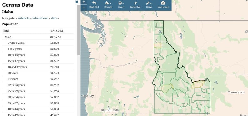
Census Data
Pro accounts and above now have access to Census data inside of your account when viewing an area at Census geographies (state, county, city, census tract, block group). Just click on the new Census tab on the left-hand sidebar to get started.
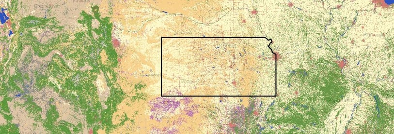
Idaho census data


New Layers
We've integrated additional base map layers onto our SaaS platform site, which you can pull up under the Layers dropdown option in the upper menu  --  look out for a growing number of these additional layers of location context in addition to the base maps you already know and love.

new layers


Take Our Survey
We want to hear from you! Please take 30 seconds to fill out our five-question survey. It is a huge help to our tam when we start planning for the future. What we work on with the site is directly related to feedback from our users, so let us know what you think and help make landgrid.com a better place!

https://goo.gl/forms/PXUBB3J4NNJKB0VG3

Thanks, The Loveland Team

Previous Next
logo

(888) 4RE-GRID

  • Contact Us
  • Customer Support
  • Privacy Policy
  • Terms of Use
  • Cookie Preferences

Subscribe for email updates

Company

  • About Regrid
  • Careers
  • Press
  • Shop Regrid Merch

Resources

  • Coverage Map
  • Support Center
  • Reports
  • Regrid Status Page

Enterprise Solutions

  • U.S. Parcels
  • Canada Parcels
  • Parcel & Tiles API
  • Roadway Right-of-Way

Self-Serve Solutions

  • Regrid Property App
  • Shop the Data Store
  • API Monthly Plans