


.png)


.svg)


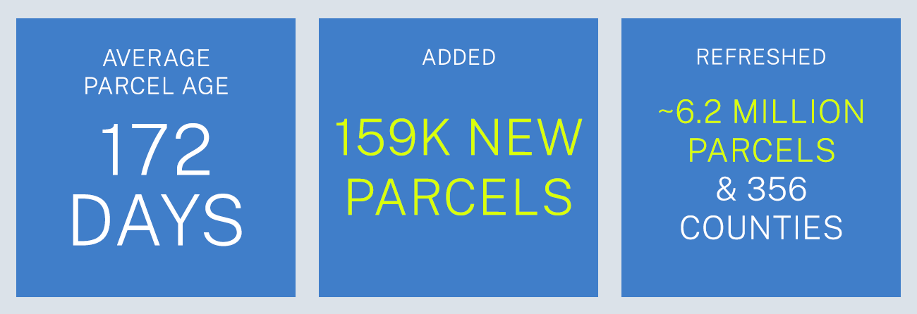
November 2022 Parcel Data Update
A detail of updates in October of 2022 and the upcoming pipeline is below.
Parquet File Format - Premium clients now have a new option for file format, Parquet. Please see our support page about the format for more information on why this format is so useful to big data pipelines and analysis.
Stacked parcels attribute roll out - This has been completed and all clients should have this new attribute in their data. Please review the archive of these monthly updates for detailed information: https://regrid.com/blog/tag/parcel-data-updates
Coverage Report - Updated for this month and available here.

A machine-readable version of this list is included in the `verse` table available in all the formats above as well as CSV format for use in spreadsheets. To find the latest updates in verse, sort by 'last_refresh' and use the 'filename_stem' column to identify the file.
Data refreshed or added in October and live now:
( Asterisk * indicates newly added county)
CA - Alameda, Calaveras, Mariposa, Mendocino, Sierra
CT - Hartford
FL - Palm Beach
GA - Bacon, Ben Hill, Bibb, Bryan, Clarke, Coffee, Columbia, Coweta, Dooly, Dougherty, Douglas, Effingham, Hall, Irwin, Jackson, Liberty, Paulding, Screven, Sumter, Union
ID - Oneida
IL - Bureau, Coles, Cook, DeKalb, Fayette, Iroquois, Jackson, Knox, Livingston*, Logan, Macon, McLean, Morgan, Moultrie, Peoria, Perry, Rock Island, Sangamon, Schuyler, Shelby, Stark, Tazewell, Vermilion, Warren, White, Whiteside, Woodford
ND - Foster, Sheridan
OH - Defiance, Union
OK - Adair, Alfalfa, Atoka, Beaver, Beckham, Blaine, Bryan, Caddo, Canadian, Carter, Cherokee, Choctaw, Cimarron, Coal, Cotton, Craig, Creek, Custer, Delaware, Dewey, Ellis, Garvin, Grady, Grant, Greer, Harmon, Harper, Haskell, Hughes, Jackson, Jefferson, Johnston, Kay, Kingfisher, Latimer, Le Flore, Lincoln, Logan, Love, Major, Marshall, Mayes, McClain, McCurtain, McIntosh, Murray, Noble, Nowata, Okfuskee, Okmulgee, Osage, Ottawa, Pawnee, Payne, Pittsburg, Pontotoc, Pottawatomie, Pushmataha, Roger Mills, Seminole, Sequoyah, Stephens, Texas, Tillman, Wagoner, Washington, Washita, Woods, Woodward
SC - Colleton
SD - Dewey*, Potter*
TX - Baylor
WI - Milwaukee
In the current pipeline for updating in November 2022:
Alabama
Colorado
Connecticut
Florida
Maine
Mississippi
Montana
New Hampshire
Ohio
South Carolina
Tennessee
In the pipeline for updating in December 2022:
Virginia
Based on feedback and county challenges, pipeline planning is always subject to change. As always, please contact us if you have any questions about accessing or using the data, if you find issues with any of our data, or you have any comments or questions about our data in specific areas or states. We also love to hear from you about which counties or regions you'd like to see us update next, as it helps inform our planning process.
Thank you for being a part of Regrid!

