×
Regrid 100: The First-Ever 100% US Land Parcel Coverage Map
Regrid logo, registered trademark
  • Enterprise Solutions

    Regrid parcel data Regrid Parcel Data

    Bulk files delivered in the format your business needs.

    • parcel -data Nationwide Parcel Data
    • matched building footprints menu icon Matched Building Footprints
    • matched secondary addresses menu icon Matched Secondary Addresses
    • enhanced ownership menu icon Enhanced Ownership

    feature service menu icon Regrid Feature Service

    Get data delivery straight into your Esri-stack, no custom integration required.

    regrid api menu icon Regrid API

    Integrate parcel boundaries & records into your app, SaaS, or map.
    • Parcel and Tiles APIcon Parcel & Tiles API
    • typeahead api icon Typeahead API
  • Self Serve Options

    Regrid Property App menu icon Regrid Property App

    Take Regrid property data wherever you go - available for web, iOS, & Android.

    data-store-2 Shop the Data Store

    Instantly download parcel geometries & associated records, by county and state.

    self-serve parcel api menu icon API Monthly Subscriptions

    Sign up and try this nationwide parcel API, free for 7 days.

    api sandbox icon Interactive API Sandbox

    Explore the API Sandbox with complete feature access to 7 counties plus Puerto Rico.
  • Markets

    Regrid for Broadband Market Broadband

    Regrid for data science Data Science

    Esri environments Esri Users

    Parcel data for green initiatives Sustainable Initiatives

    Parcel data for real estate Real Estate

    Parcel data for nonprofit and academia Nonprofit & Academia

    Regrid's Data With Purpose program - propose your own budget to access land parcel data. 

    Plus sign icon Your Business or Organization

    Regrid’s data spans all industries needing land insight.
  • Resources

    support menu icon Support

    Access documentation & support materials to learn about Regrid data.
    • Support site resource icon Support Site
    • tutorial videos resources icon Tutorial Videos
    • parcel data faqs resources icon Parcel Data FAQs
    • property app faqs Property App FAQs
    • coveragemap_resources_icon Coverage Map
    • land use codes menu item Land Use Codes
    • vacancy data menu icon Vacancy Data

    content resources menu icon Content

    Dive into Regrid's world of land parcels & learn about location intelligence.
    • blog resources icon Blog
    • webcasts resources icon Webcasts
    • reports resources icon Reports
    • podcast resources icon Living In The Map

    customers resources icon Customers

    Hear what our customers say have to say & see how they use Regrid data.
    • testimonials resources icon Testimonials
    • Case Studies resources icon Case Studies
  • Contact Us

    Contact a parcel data expert menu icon Contact A Parcel Data Expert

    Contact Regrid parcel data experts to learn more about our offerings.

    Customer Support menu icon Customer Support

    Contact our customer support team & get the help you need.

    megamenu nav image Press & Media Inquires

    Find the information you need & get in touch with our marketing department.
  • Go To Map
Go To Map
  • Enterprise Solutions

    Regrid Parcel Data

    • Nationwide Parcel Data
    • Matched Building Footprints
    • Matched Secondary Addresses
    • Enhanced Ownership

    Regrid Feature Service

    Regrid API

    • Parcel & Tiles API
    • Typeahead API
  • Self Serve Options

    Regrid Property App

    Shop the Data Store

    API Monthly Subscriptions

    Interactive API Sandbox

  • Markets

    Broadband

    Data Science

    Esri Users

    Sustainable Initiatives

    Real Estate

    Nonprofit & Academia

    Your Business or Organization

  • Resources

    Support

    • Support Site
    • Tutorial Videos
    • Parcel Data FAQs
    • Property App FAQs
    • Coverage Map
    • Land Use Codes
    • Vacancy Data

    Content

    • Blog
    • Webcasts
    • Reports
    • Living In The Map

    Customers

    • Testimonials
    • Case Studies
  • Contact Us

    Contact A Parcel Data Expert

    Customer Support

    Press & Media Inquires

  • Go To Map

The Regrid Blog

Discover the Latest in Land Parcels & Spatial Data with the Regrid Team!

Regrid Blog

Living In The Map

Categories

  • Announcements
  • Democratizing Data
  • Regrid Updates
  • Parcel Data Updates
  • Product How-To
  • Use Cases
  • Customer & Guest Blogs
  • All About Parcel Data
  • Working at Regrid
  • Regrid 100

The Point of Beginning: New Life Through An Old Land Grid

Jerry Paffendorf October 25, 2023

File this one under The Significance.

If I told you I could cast a magic spell on the surface of the Earth to attract and organize a civilization, would you believe me?


If you said yes, I truly appreciate the support, but the more likely answer is obviously not.


And yet an actual magic spell of this sort was cast in the form of the legal property boundary systems of the United States as we know and occupy it today. 


The Regrid team is celebrating the first-ever 100% US land parcel coverage map, with data in every county. Throughout the rest of 2023 we’ll be sharing posts that reflect on The Journey, The Significance, and The Future of this dataset at regrid.com/100 and on social media with the hashtag #Regrid100. 


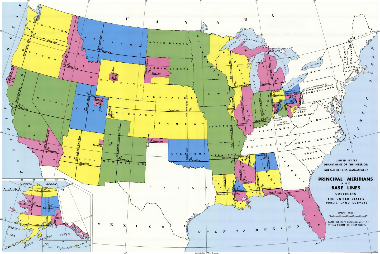
“There is nothing to suggest that it was here the United States began to take physical shape, nothing to indicate that from here a grid was laid out across the land that would stretch west to the Pacific Ocean, and north to Canada, and south to the Mexican border, and would cover more than three million square miles, and would create a structure of land ownership unique in history, and would provide the invisible web that supported the legend of the frontier with its covered wagons and cowboys, it's farmers and gold miners, and would insidiously permeate its formation into the unconscious mind of every American who ever owned a square yard of soil."
– from Measuring America by Andro Linklater


Pasta Batman, esteemed Regrid cartdographer
The Beginning of the U.S. Public Land Survey
1112 feet from this spot... marker
The Point of Beginning plaque
The Seven Ranges
Gateway to the Northwest
Erected in 1881 by a joint commission...

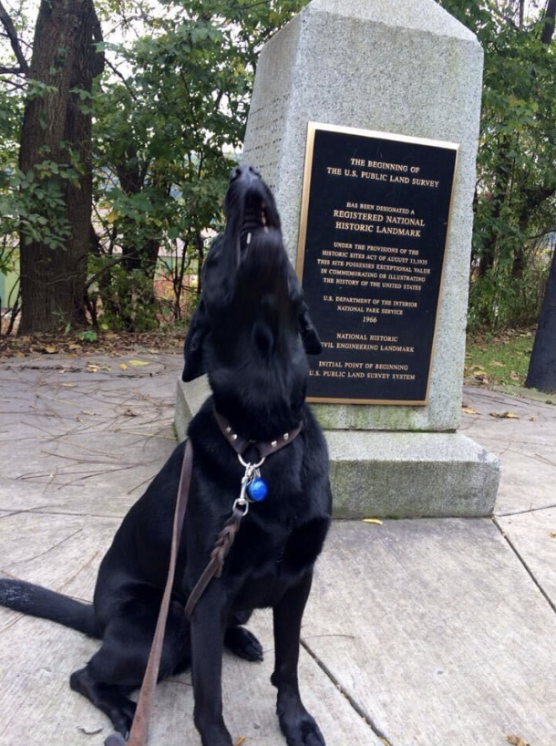
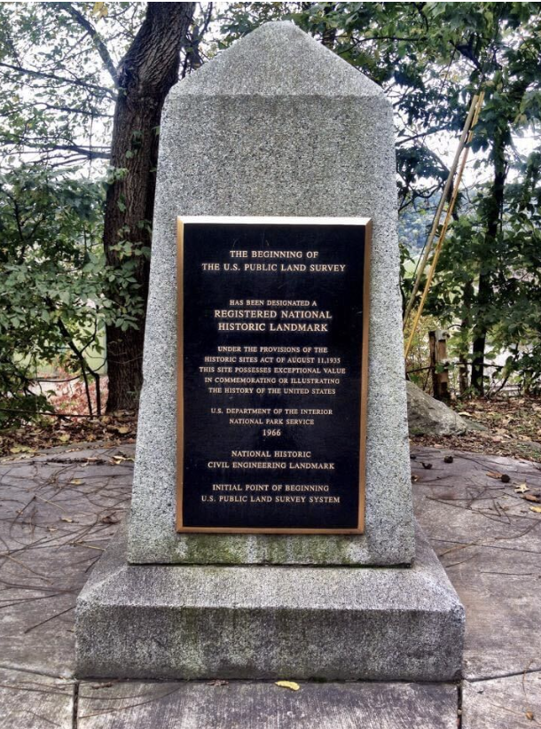
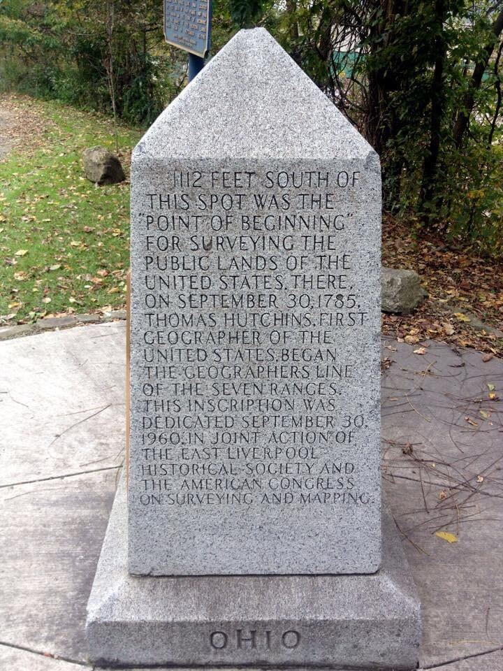
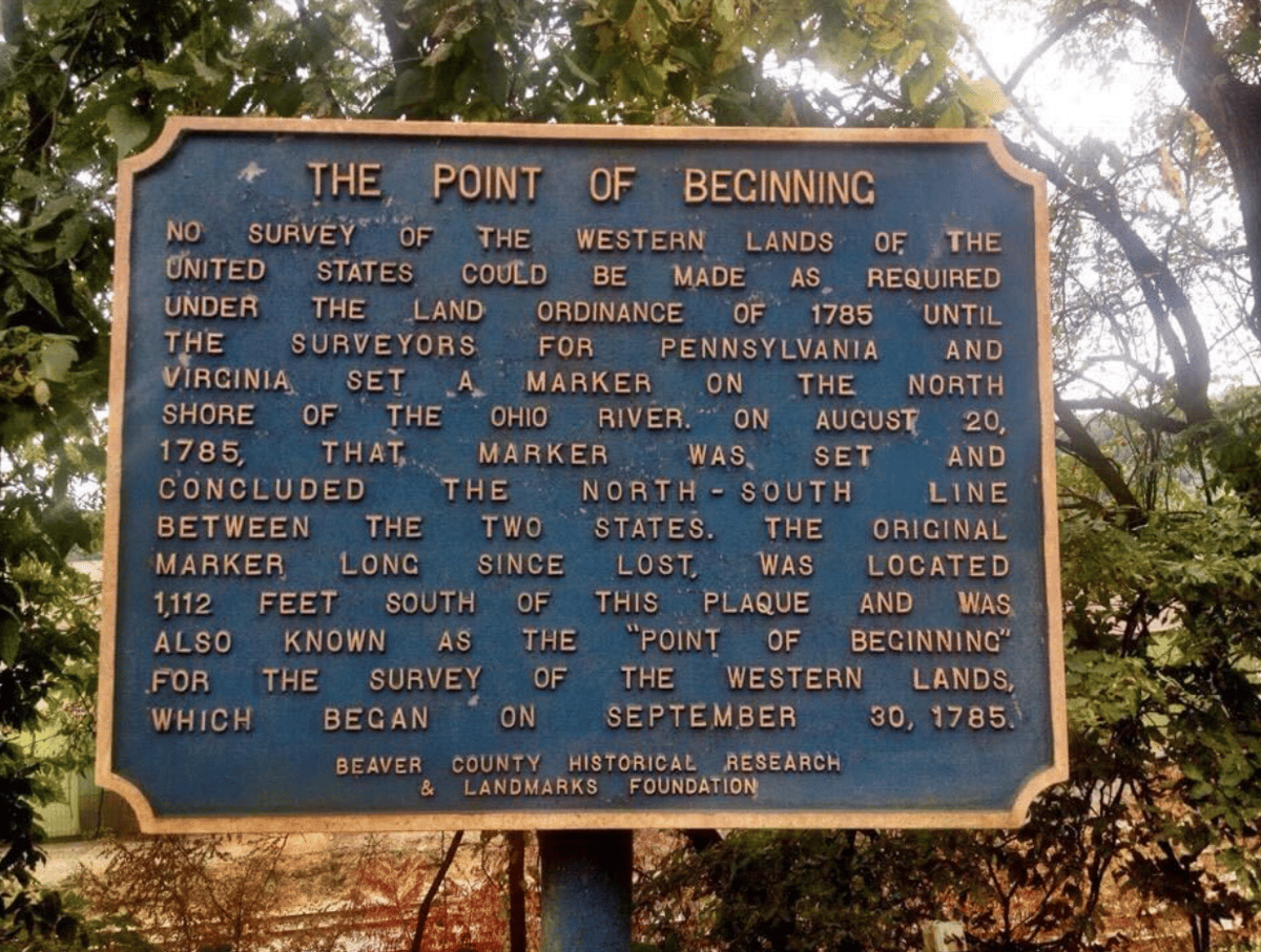
 Some 2014 pictures from The Point of Beginning monument in East Liverpool, Ohio.


Nearly 10 years ago my wife Mary and I, along with our dog, the esteemed cartdographer Pasta Batman, visited The Point of Beginning of the U.S. Public Land Survey in East Liverpool, Ohio.


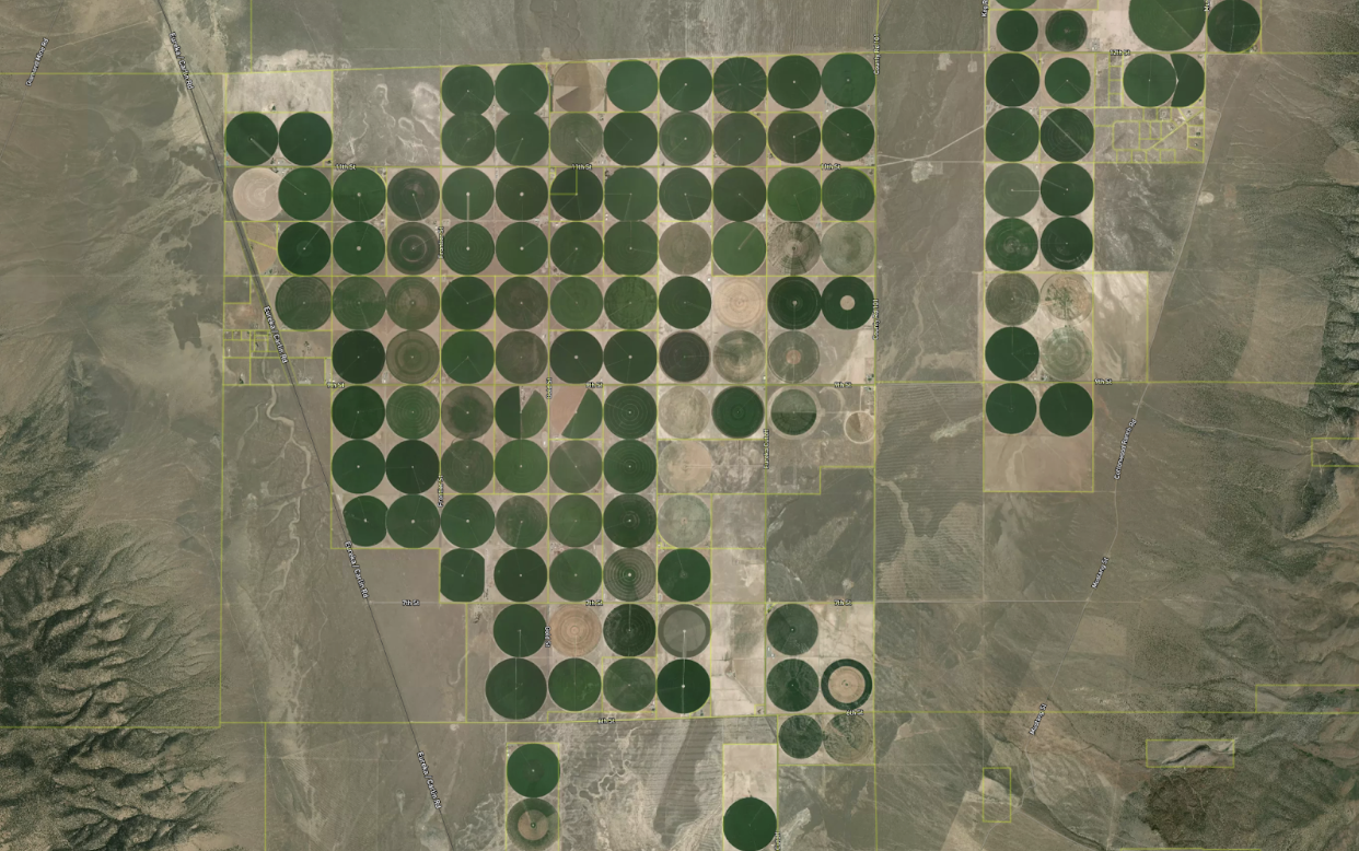
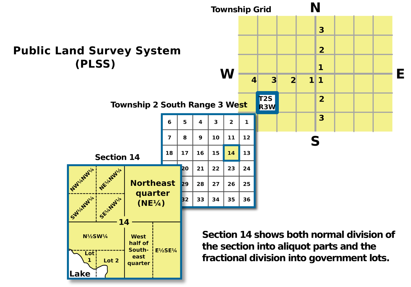
In 1785, from this point heading west in a nation-building project called the US Public Land Survey, surveyors dragged 66-foot chains to map an enormous grid of square mile sections that snapped together into townships, counties, and states which were then further subdivided into smaller land parcels like the ones you and I live on.


A map of Pricipal Meridians and Base Lines governing the United Staes public land surveys.A map of the United States covered by the PLSS grid survey.


This ice cube tray of orderly space caused people to cross oceans and pour their lives into it, and allowed the government to more or less understand what was going on. In a time far before digital maps and smartphones, it functioned as a legible trellis for a flash mob of human settlement on a scale the planet may not have seen before.


Public Land Survey System (PLSS)A view of how the square mile survey labeled and snapped parcels together into townships, and was further subdivided into smaller sections. I highly recommend Dr. Nancy Von Meyer's very digestible blog series on the PLSS for more detail on the process (also follow her online as Von Parcel).


You can see the legacy of the ice cube tray hiding in plain sight at every level of a US boundary map, from the straight lines of many states, to the uniformity of many counties and townships, down to the general widths of streets and their relationship to smaller land parcels. 


Jerry holds a copy of 'Measuring America' by Andro Linklater.


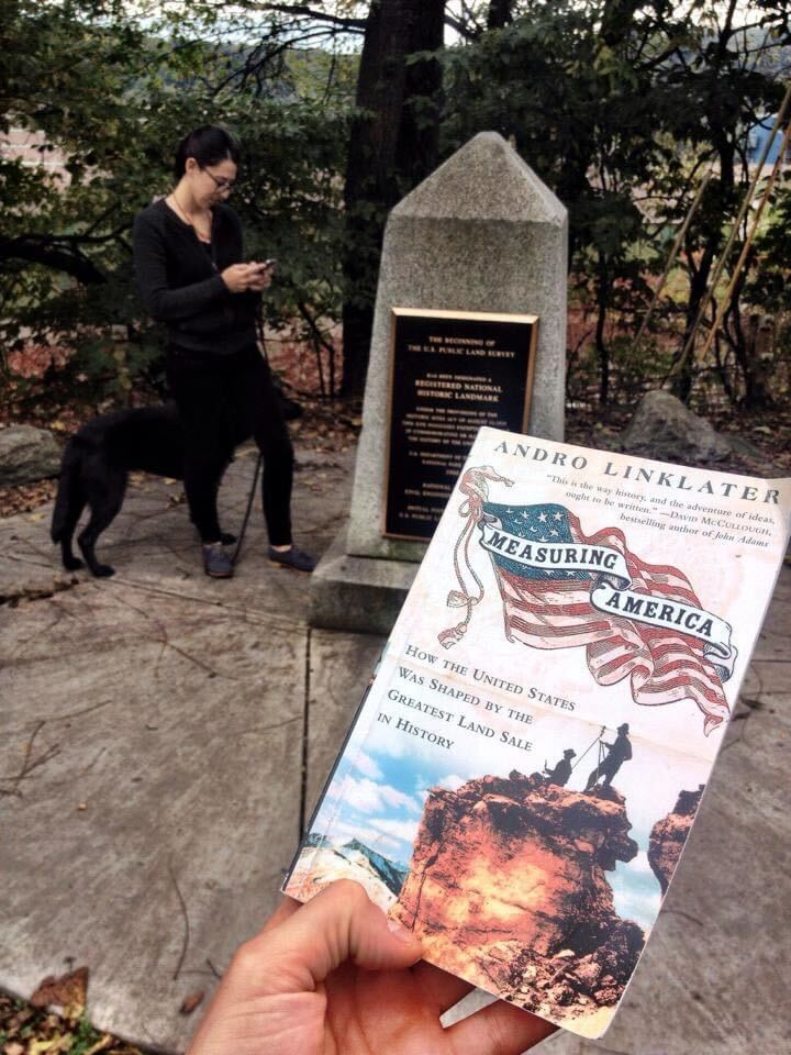
The best telling of the spell, why it was cast, and how many eyes of newt were added to make it work is a book called Measuring America: How The United States Was Shaped By The Greatest Land Sale In History, by the late Andro Linklater — a copy of which we brought to The Point of Beginning, and with which pairs his book about global land ownership, Owning The Earth: The Transforming History of Land Ownership.


The spell worked so well that over time it simply became an invisible part of the way things are. As happens, there are good and bad things about this.


The good part is that the system is orderly, and for humans to function happily we can’t just go around changing everything all the time. 


The bad part is a combination of the arbitrary way we plowed into the ice cube tray combined with our assumption that it is ideal, permanent, and unchangeable, even when the needs of our communities and country change.


We essentially have a situation where the needs of new life are bumping up against the constraints of an old land grid that started as a helpful framework and concretized into a dogmatic religion we can’t even see how we practice. 


I’ll give one example, where we started our work, in Detroit.


Detroit had 1.8 Million people in 1950, and has around 600,000 now. As two-thirds of the people left, the underlying land grid of parcels saw no significant change or reduction in number.


You can legitimately ask, are there too few people in Detroit or too many land parcels? Some of the best human-centered and economic development projects in the city today seem to be simple things like expanded waterfronts and greenways that acknowledge that land can and should be used differently than they once were. 


And different flavors of this question, challenge, and opportunity are present across the country. As the desirability and need for housing, energy, transportation, and resources change across geographies, populations and desirable land uses necessarily change as well. However the underlying land grid remains largely the same, peppered by fragmented ownership and a hodgepodge of stodgy permissions assigned at an earlier time. 


Step one for planning new life on an old land grid is seeing the actual lay of the land: how it is currently subdivided, owned, and used. 


This is what Regrid dedicated itself to with the creation of the first-ever 100% US land parcel coverage map. 


From this starting point, a million conversations, plans, actions, and new points of beginning can happen.

Previous Next
logo

(888) 4RE-GRID

  • Contact Us
  • Customer Support
  • Privacy Policy
  • Terms of Use

Subscribe for email updates

Company

  • About Regrid
  • Careers
  • Press

Resources

  • Coverage Map
  • Support Center
  • Reports

Support

  • Parcel Data FAQs
  • Property App FAQs
  • Contact Support Team

Customers

  • Customer Stories
  • Case Studies
  • Non Profit & Academia

Enterprise Solutions

  • Nationwide Land Parcels
  • Parcel & Tiles API
  • Feature Service

Self-Serve Solutions

  • Regrid Property App
  • Shop the Data Store
  • API Monthly Plans