Regrid logo, registered trademark
  • Enterprise Solutions

    Regrid parcel data Regrid Parcel Data

    Bulk files delivered in the format your business needs.

    • parcel -data Nationwide Parcel Data
    • matched building footprints menu icon Matched Building Footprints
    • matched secondary addresses menu icon Matched Secondary Addresses
    • enhanced ownership menu icon Enhanced Ownership

    feature service menu icon Regrid Feature Service

    Get data delivery straight into your Esri-stack, no custom integration required.

    regrid api menu icon Regrid API

    Integrate parcel boundaries & records into your app, SaaS, or map.
    • Parcel and Tiles APIcon Parcel & Tiles API
    • typeahead api icon Typeahead API
  • Self Serve Options

    Regrid Property App menu icon Regrid Property App

    Take Regrid property data wherever you go - available for web, iOS, & Android.

    data-store-2 Shop the Data Store

    Instantly download parcel geometries & associated records, by county and state.

    self-serve parcel api menu icon API Monthly Subscriptions

    Sign up and try this nationwide parcel API, free for 7 days.

    api sandbox icon Interactive API Sandbox

    Explore the API Sandbox with complete feature access to 7 counties plus Puerto Rico.
  • Markets

    Regrid for Broadband Market Broadband

    Regrid for data science Data Science

    Parcel data for green initiatives Sustainable Initiatives

    Parcel data for real estate Real Estate

    Parcel data for nonprofit and academia Nonprofit & Academia

    Regrid's Data With Purpose program - propose your own budget to access land parcel data. 

    Plus sign icon Your Business or Organization

    Regrid’s data spans all industries needing land insight.
  • Resources

    support menu icon Support

    Access documentation & support materials to learn about Regrid data.
    • Support site resource icon Support Site
    • tutorial videos resources icon Tutorial Videos
    • parcel data faqs resources icon Parcel Data FAQs
    • property app faqs Property App FAQs
    • coveragemap_resources_icon Coverage Map
    • land use codes menu item Land Use Codes
    • vacancy data menu icon Vacancy Data

    content resources menu icon Content

    Dive into Regrid's world of land parcels & learn about location intelligence.
    • blog resources icon Blog
    • webcasts resources icon Webcasts
    • reports resources icon Reports
    • podcast resources icon Living In The Map

    customers resources icon Customers

    Hear what our customers say have to say & see how they use Regrid data.
    • testimonials resources icon Testimonials
    • Case Studies resources icon Case Studies
  • Contact Us

    Contact a parcel data expert menu icon Contact A Parcel Data Expert

    Contact Regrid parcel data experts to learn more about our offerings.

    Customer Support menu icon Customer Support

    Contact our customer support team & get the help you need.

    megamenu nav image Press & Media Inquires

    Find the information you need & get in touch with our marketing department.
  • Go To Map
Go To Map
  • Enterprise Solutions

    Regrid Parcel Data

    • Nationwide Parcel Data
    • Matched Building Footprints
    • Matched Secondary Addresses
    • Enhanced Ownership

    Regrid Feature Service

    Regrid API

    • Parcel & Tiles API
    • Typeahead API
  • Self Serve Options

    Regrid Property App

    Shop the Data Store

    API Monthly Subscriptions

    Interactive API Sandbox

  • Markets

    Broadband

    Data Science

    Sustainable Initiatives

    Real Estate

    Nonprofit & Academia

    Your Business or Organization

  • Resources

    Support

    • Support Site
    • Tutorial Videos
    • Parcel Data FAQs
    • Property App FAQs
    • Coverage Map
    • Land Use Codes
    • Vacancy Data

    Content

    • Blog
    • Webcasts
    • Reports
    • Living In The Map

    Customers

    • Testimonials
    • Case Studies
  • Contact Us

    Contact A Parcel Data Expert

    Customer Support

    Press & Media Inquires

  • Go To Map

Regrid Reports

Check out the official reports on customer property survey and data analyses projects using the Regrid Parcel Data

Regrid Blog

Living In The Map

Categories

  • Reports
Community Driven Growth A Roadmap for Dallas' Equitable Development by TREC

Community Driven Growth: A Roadmap for Dallas Equitable Development

Matt Hampel January 30, 2020

The Community Driven Growth initiative is funded by the JPMorgan Chase Partnerships for Raising Opportunity in Neighborhoods (PRO Neighborhoods) — a $125 million, five-year initiative to provide communities with the capital and tools they need to support locally driven solutions and address key drivers of inequality across the country. The program uses an equitable development approach to economic growth by helping cities implement comprehensive strategies that address barriers to economic mobility. The project partners, responsible for project administration and the final report, are The Real Estate Council Community Fund (TREC Community Fund), C-Suite Consulting, buildingcommunityWORKSHOP ([bc]), The Institute for Urban Policy Research at The University of Texas at Dallas (IUPR), and Loveland Technologies.


Community Driven Growth


More Information


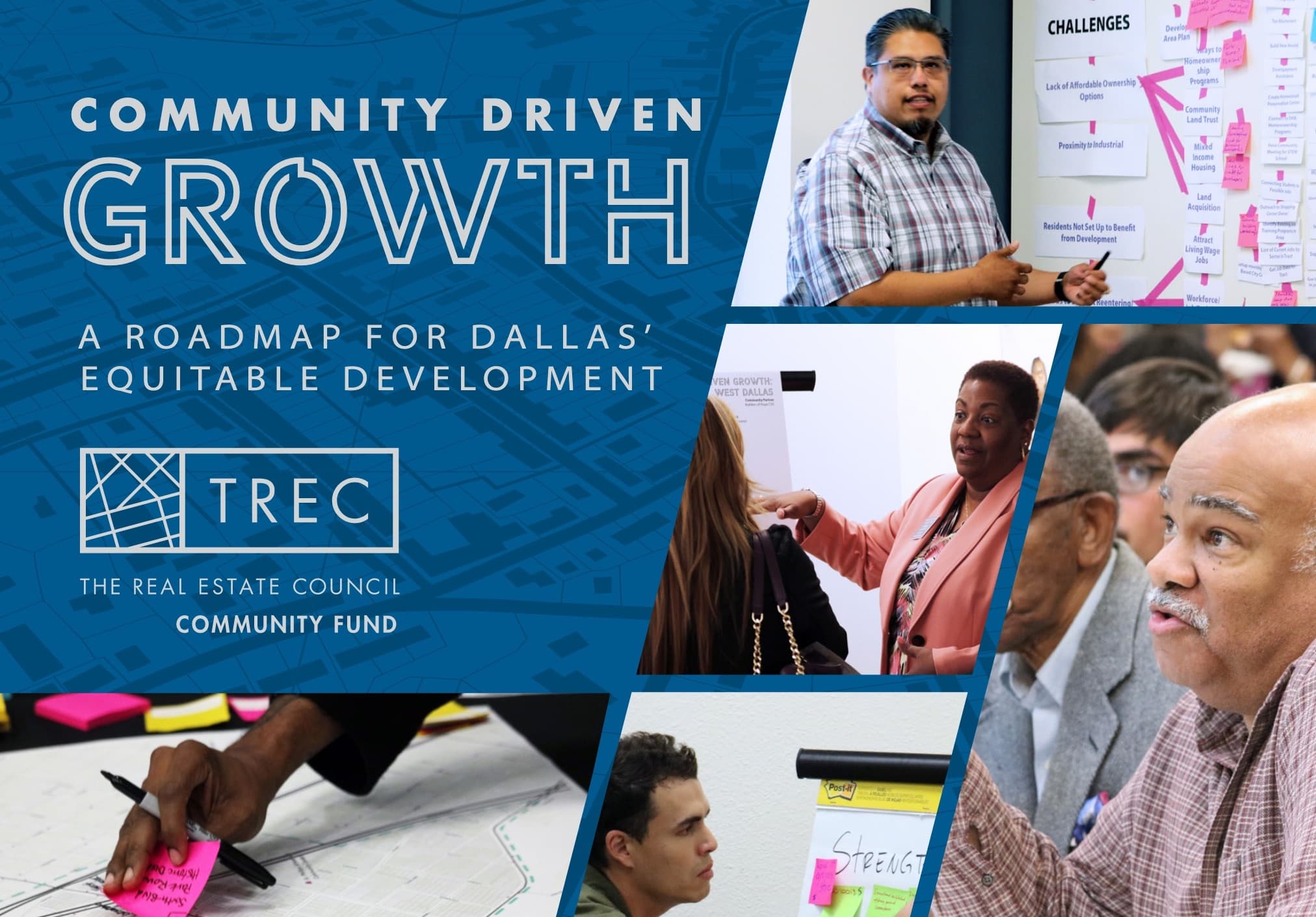
Equitable development as both an idea and a practice is evolving. Recentering development and investment so they benefit residents of disinvested communities is at the core of delivering equitable development. Our knowledge of tools, strategies, and tactics continues to grow as communities, stakeholders, practitioners, and community-based organizations across the country seek to undo decades of disinvestment and discriminatory policies and practices without causing widespread displacement. Community Driven Growth: A Roadmap for Dallas’ Equitable Development represents a year-long effort for three Dallas communities - The Bottom, Forest District, and West Dallas-Census Tract 205. It recognizes the distinct histories of each geography and turning points which contributed to the challenges they face today. Despite their differences, common challenges quickly emerged across the three geographies. This plan pulls from the current knowledge of equitable development tools and seeks to pair them with the challenges identified by residents and stakeholders in each community.

Common Challenges:

• Need for Housing Rehabilitation

• Need to better manage new development to ensure residents are not displaced, and that housing in the community continues to be financially accessible to very low-, low-, and moderate-income households.


Jobs & Workforce Development

• Jobs & Workforce Development

• Need to support individuals who are reentering the workforce or considered hard-to-hire

• Need for jobs to pay a living wage

• Need to better connect residents to currently available resources


Community Ownership and Leadership

• Need for increased community participation

• Need for better engagement/communication with residents

• Need for resident education and leadership development


Community Specific Recommendations:

• The Bottom

• Establish affordability based on the income of current Bottom residents

• Forest District

• Attract small businesses

• Form a super neighborhood organization

• West Dallas-Census Tract 205

• Relocate Industrial Uses

Previous Next
logo

(888) 4RE-GRID

  • Contact Us
  • Customer Support

Subscribe for email updates

Company

  • About Regrid
  • Careers
  • Press

Resources

  • Coverage Map
  • Support Center
  • Reports

Support

  • Parcel Data FAQs
  • Property App FAQs
  • Contact Support Team

Customers

  • Customer Stories
  • Case Studies
  • Non Profit & Academia

Enterprise Solutions

  • Nationwide Land Parcels
  • Parcel & Tiles API
  • Feature Service

Self-Serve Solutions

  • Regrid Property App
  • Shop the Data Store
  • API Monthly Plans