Regrid logo, registered trademark
  • Enterprise Solutions

    Regrid parcel data Regrid Parcel Data

    Bulk files delivered in the format your business needs.

    • parcel -data Nationwide Parcel Data
    • matched building footprints menu icon Matched Building Footprints
    • matched secondary addresses menu icon Matched Secondary Addresses
    • enhanced ownership menu icon Enhanced Ownership

    feature service menu icon Regrid Feature Service

    Get data delivery straight into your Esri-stack, no custom integration required.

    regrid api menu icon Regrid API

    Integrate parcel boundaries & records into your app, SaaS, or map.
    • Parcel and Tiles APIcon Parcel & Tiles API
    • typeahead api icon Typeahead API
  • Self Serve Options

    Regrid Property App menu icon Regrid Property App

    Take Regrid property data wherever you go - available for web, iOS, & Android.

    data-store-2 Shop the Data Store

    Instantly download parcel geometries & associated records, by county and state.

    self-serve parcel api menu icon API Monthly Subscriptions

    Sign up and try this nationwide parcel API, free for 7 days.

    api sandbox icon Interactive API Sandbox

    Explore the API Sandbox with complete feature access to 7 counties plus Puerto Rico.
  • Markets

    Regrid for Broadband Market Broadband

    Regrid for data science Data Science

    Parcel data for green initiatives Sustainable Initiatives

    Parcel data for real estate Real Estate

    Parcel data for nonprofit and academia Nonprofit & Academia

    Regrid's Data With Purpose program - propose your own budget to access land parcel data. 

    Plus sign icon Your Business or Organization

    Regrid’s data spans all industries needing land insight.
  • Resources

    support menu icon Support

    Access documentation & support materials to learn about Regrid data.
    • Support site resource icon Support Site
    • tutorial videos resources icon Tutorial Videos
    • parcel data faqs resources icon Parcel Data FAQs
    • property app faqs Property App FAQs
    • coveragemap_resources_icon Coverage Map
    • land use codes menu item Land Use Codes
    • vacancy data menu icon Vacancy Data

    content resources menu icon Content

    Dive into Regrid's world of land parcels & learn about location intelligence.
    • blog resources icon Blog
    • webcasts resources icon Webcasts
    • reports resources icon Reports
    • podcast resources icon Living In The Map

    customers resources icon Customers

    Hear what our customers say have to say & see how they use Regrid data.
    • testimonials resources icon Testimonials
    • Case Studies resources icon Case Studies
  • Contact Us

    Contact a parcel data expert menu icon Contact A Parcel Data Expert

    Contact Regrid parcel data experts to learn more about our offerings.

    Customer Support menu icon Customer Support

    Contact our customer support team & get the help you need.

    megamenu nav image Press & Media Inquires

    Find the information you need & get in touch with our marketing department.
  • Go To Map
Go To Map
  • Enterprise Solutions

    Regrid Parcel Data

    • Nationwide Parcel Data
    • Matched Building Footprints
    • Matched Secondary Addresses
    • Enhanced Ownership

    Regrid Feature Service

    Regrid API

    • Parcel & Tiles API
    • Typeahead API
  • Self Serve Options

    Regrid Property App

    Shop the Data Store

    API Monthly Subscriptions

    Interactive API Sandbox

  • Markets

    Broadband

    Data Science

    Sustainable Initiatives

    Real Estate

    Nonprofit & Academia

    Your Business or Organization

  • Resources

    Support

    • Support Site
    • Tutorial Videos
    • Parcel Data FAQs
    • Property App FAQs
    • Coverage Map
    • Land Use Codes
    • Vacancy Data

    Content

    • Blog
    • Webcasts
    • Reports
    • Living In The Map

    Customers

    • Testimonials
    • Case Studies
  • Contact Us

    Contact A Parcel Data Expert

    Customer Support

    Press & Media Inquires

  • Go To Map

The Regrid Blog

Discover the Latest in Land Parcels & Spatial Data with the Regrid Team!

Regrid Blog

Living In The Map

Categories

  • Announcements
  • Democratizing Data
  • Regrid Updates
  • Parcel Data Updates
  • Product How-To
  • Use Cases
  • Customer & Guest Blogs
  • All About Parcel Data
  • Working at Regrid
'All About Parcel Data' Blog #2 - History of Parcel Data

History of Parcel Data - All About Parcel Data #2

Meg Oppenheim March 10, 2022

This is blog #2 in our 'All About Parcel Data' series. Read blog #1 here.


"The access to and acquisition of land drove much of American history. From wars, treaties, immigration, and settlement, land is interwoven into the very core of what it means to be America."


- Land Records, National Archives


What is a land parcel? A quick google search won’t reveal much.  Wikipedia uses the terms ‘land parcel data’ and ‘property data’ interchangeably; the technical term is cadastral data, it's more commonly referred to as parcel data here in the US. This data includes the exact coordinates of a parcel of land, ownership information, zoning, land-use, value, etc. 


Since the rise of civilization, land ownership has played a vital role in political power. As empires grew, as did the need for precise information as to 'who owned what’. Though the concept of systematic land surveys has been in history place since ancient times, it is only in more modern society that geographical inventory became a staple government practice.


Parcel data can be traced all the way back to emperors of Rome who used maps to keep track of publicly owned land that was being used privately - this is how they taxed residents. After the fall of Rome, the use of precise cadastral maps was largely abandoned until its revival during the Renaissance era.


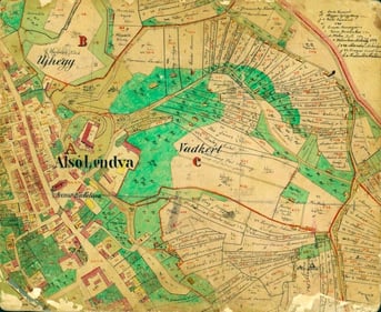
It wasn’t until the sixteenth century that cadastre maps began to reappear in the Netherlands as a means of cataloging land drainage to manufacture new land in coastal villages. The maps that resulted from this project eventually became the basis for taxation.


Delft Cadastral Map circa 1611 A map of Lendava, Slovenia circa 1864


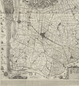
(Left - Delft circa 1611; Old Maps Online)

(Right - Lendava, Slovenia circa 1864; Arcanum Maps)


As capitalism emerged in Renaissance Europe, the need for parcel data grew. Property data played an important role in the rise of modern Europe. It was a tool to determine and maintain control of land as a means of production. 


There are hundreds of thousands of surviving cadastral maps in European archives - each in its own unique mapping style, conveying land boundaries and ownership, as well as other details about a particular location. In the United States, it seems not a lot has changed in the last few hundred years. There are ~3200 counties in the United States alone, and no standard way of collecting, reporting, and disseminating parcel data information.


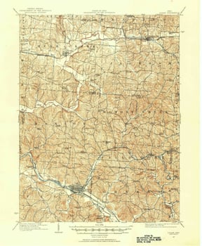
In 1785, the Public Lands Survey System (PLSS) was born in the United States. Using a rectangular grid, a township was recorded by its relation to a baseline (a parallel line going from East to West) and the principal meridian. Modern-day Ohio was the first territory surveyed by this modern system.


This cadastral survey was made relative to the principal meridian and baselines. Land entries were historically filed by surveyors in relation to the township the land belonged to. The General Land Office (which became the Bureau of Land Management in 1946) was responsible for the sale of this federal land.


Map of the States of Ohio, Indiana, and Illinois and part of Michigan Territory, 1826Ohio State land survey from 1907

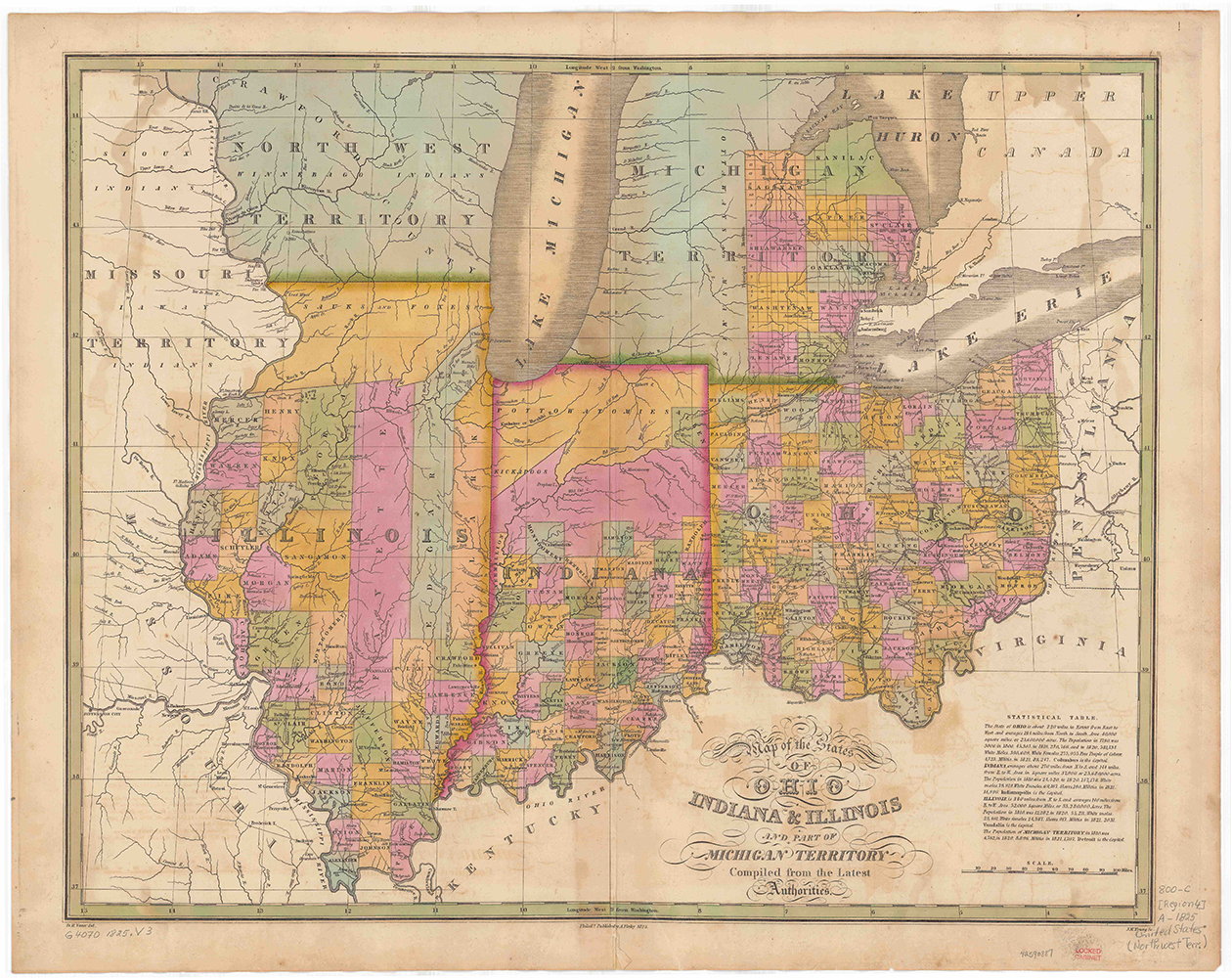
(Left - Map of the States of Ohio Indiana & Illinois and part of Michigan Territory, 1826; David Rumsey Map Collection)

(Right - Ohio State Land Survey, 1907 : USGS topoView)


It’s 2022 and no headway has been made by the American government to create a reliable, standardized database of parcel data - information on land use, ownership, and value is fundamental to sustainable and productive management of the land’s resources. Current cadastral information is crucial to understanding geographical patterns and improving urban development.


Parcel data has influenced government decisions with regards to law enforcement, business regulation, taxes, and emergency response; “almost every aspect of government and business can be associated with a land parcel” (National Land Parcel Data: A Vision for the Future, xi). In 1980, a report titled Need for a Multipurpose Cadastre was published by the National Research Council. This report stated the need for a nationally integrate set of parcel data in order to retrieve information and connect findings with other data files. The report came out over 40 years ago and the United States has been unable to achieve this vision. According to research from 2007, only a third of US counties published digital parcel data.


This lack of standardization is key in understanding why the Regrid Data Team’s work is so valuable; it’s a massive task to collect and standardize this data. We are shaping location intelligence -- modernizing parcel data and making the data accessible.


We have standardized over 152 million parcels covering 99% of the population and growing. Most recently, we have augmented & pre-joined our parcel records with additional datasets to create enhanced location certainty products - including premium parcels + matched secondary addresses, and premium parcels + matched building footprints.


If you have any questions about our data or would like a trial token, please reach out to our team at parcels@regrid.com. 

Previous Next
logo

(888) 4RE-GRID

  • Contact Us
  • Customer Support

Subscribe for email updates

Company

  • About Regrid
  • Careers
  • Press

Resources

  • Coverage Map
  • Support Center
  • Reports

Support

  • Parcel Data FAQs
  • Property App FAQs
  • Contact Support Team

Customers

  • Customer Stories
  • Case Studies
  • Non Profit & Academia

Enterprise Solutions

  • Nationwide Land Parcels
  • Parcel & Tiles API
  • Feature Service

Self-Serve Solutions

  • Regrid Property App
  • Shop the Data Store
  • API Monthly Plans