×
Enhanced Ownership - Get Daily Delivery of Changes!
Regrid TM Logo
  • Products

    Data

    • Nationwide Parcel Data Nationwide Parcel Data
    • Parcel API & Tiles Parcel API & Tiles
    • Parcels and Matched Building Footprints Parcels + Matched Building Footprints
    • addresses-menu-icon Parcels + Matched Secondary Addresses
    • Enhanced Ownership Enhanced Ownership Parcel Data Add-On

    Self-Serve Tools

    • Data Store Data Store
    • Property App Property App
    • Mapping Tools Self-Serve API Plans
  • Markets

    • datascience-usecase Data Science
    • featureservice-menuicon Feature Service
    • support-site_nav-1 Land Use Codes
    • Data With Purpose Non-Profit
    • Real Estate Use Case page symbol Real Estate
    • renewables-usecase Renewable Energy
    • blog_nav Vacancy
  • Resources

    Content

    • Regrid Blog Blog
    • Coverage Map Coverage Map
    • Reports Reports
    • Webcasts Webcasts

    Support

    • Parcel Data FAQ Parcel Data FAQ
    • Property Platform FAQ Property App FAQs
    • Support Site Support Site
    • Tutorial Videos Tutorial Videos

    Customers

    • Customer Stories Customer Stories
    • Case Studies Case Studies
    • Data with purpose logo Data With Purpose
  • Contact Us
Go to Map
  • Products

    Data

    • Nationwide Parcel Data Nationwide Parcel Data
    • Parcel API & Tiles Parcel API & Tiles
    • Parcels and Matched Building Footprints Parcels + Matched Building Footprints
    • addresses-menu-icon Parcels + Matched Secondary Addresses
    • Enhanced Ownership Enhanced Ownership Parcel Data Add-On

    Self-Serve Tools

    • Data Store Data Store
    • Property App Property App
    • Mapping Tools Self-Serve API Plans
  • Markets

    • datascience-usecase Data Science
    • featureservice-menuicon Feature Service
    • support-site_nav-1 Land Use Codes
    • Data With Purpose Non-Profit
    • Real Estate Use Case page symbol Real Estate
    • renewables-usecase Renewable Energy
    • blog_nav Vacancy
  • Resources

    Content

    • Regrid Blog Blog
    • Coverage Map Coverage Map
    • Reports Reports
    • Webcasts Webcasts

    Support

    • Parcel Data FAQ Parcel Data FAQ
    • Property Platform FAQ Property App FAQs
    • Support Site Support Site
    • Tutorial Videos Tutorial Videos

    Customers

    • Customer Stories Customer Stories
    • Case Studies Case Studies
    • Data with purpose logo Data With Purpose
  • Contact Us

The Regrid Blog

Discover the Latest in Land Parcels & Spatial Data with the Regrid Team!

Categories

  • Announcements
  • Democratizing Data
  • Regrid Updates
  • Parcel Data Updates
  • Product How-To
  • Use Cases
  • Customer & Guest Blogs
  • Working at Regrid
  • All About Parcel Data
  • Living In The Map (w/ CEO Jerry Paffendorf)
How Regrid Data Helped Research in Puerto Rico after Hurricane Maria

How Regrid Data Helped Research in Puerto Rico After Hurricane Maria

Francis Russell May 27, 2022

How Regrid Land Parcel Data Helped this Researcher Assess Hurricane Damage to Coffee Farms in Puerto Rico

One of the benefits of working with land parcel data from Regrid is the ability to take other forms of geospatial data and identify which parcels they affect or interact with. Oftentimes, geospatial data comes as points of interest (POI) which show where something happened, or where a data point is located, but not what property the data is associated with, nor that property’s underlying ownership, assessment, and use information.


If you need to know more than simply “where,” you need Regrid. 


puertorico-dwptestimonials


For researchers, academics, and non-profits, Regrid’s Data With Purpose program can get you the parcel boundaries and data you need, on a pay-what-you-can basis. What’s more, unlike other parcel providers, we’ll get back to you quickly, and get you what you need as fast as we can.


Apply for Data With Purpose.


A Guest post by Data With Purpose participant, Francis Russell. Francis is a second year Master's student and an incoming Doctoral student working with Dr. Carlos Ramos in the Department of Geography at the University of Texas - Austin.


All Coffee Farms in Puerto Rico Parcels Map and Points


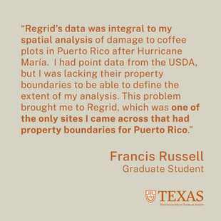
Regrid’s data was integral to my spatial analysis of damage to coffee plots in Puerto Rico after Hurricane María. I used LiDAR data to derive Digital Surface Models from before and after the hurricane to assess the loss of vegetation on coffee farms due to María. I had point data from the USDA that showed locations of coffee farms on the island, but I was lacking their property boundaries to be able to define the extent of my analysis. This brought me to Regrid, which was one of the only sites I came across that had property boundaries for Puerto Rico. 


I reached out about their Data With Purpose program to see if I could qualify to receive the data that I needed free of charge, and they were happy to help. 


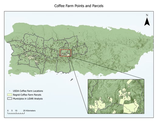
The property boundaries from Regrid allowed me to analyze the vegetation loss on roughly 450 farms in 15 different municipalities. Additionally, a few locations of coffee farms were added to the database thanks to the information in the attributes of the parcel shapefiles. The results of the damage assessment were then aggregated to the municipality level in order to compare the amounts of vegetation loss between municipalities. These results will contribute to the growing field of disaster studies and literature regarding the spatial variability of damage to agricultural plots after hurricanes in Puerto Rico.


Example of parcel with plant pix and loss pix

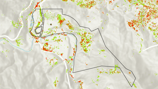
This photo shows the pre-hurricane coffee height vegetation pixels (green) as well as the post-hurricane coffee loss pixels (red). The point was one designating a coffee farm from the USDA site and the polygon is one of Regrid’s property boundary shapefiles.


Apply for Data With Purpose


Researching coffee haciendas in Puerto Rico after Hurricane Maria

Previous Next
logo

help@regrid.com

(888) 4RE-GRID

440 Burroughs St, Suite 672 Detroit, MI 48202

  • Contact Us

Subscribe to our email updates -

Regrid is a creation of Loveland Technologies.

Company

  • About Us
  • Careers
  • Why Regrid?
  • Press

Resources

  • Coverage Map
  • Support Center
  • Reports

Support

  • Parcel Data FAQ
  • Platform FAQ
  • Contact Us
  • Site Status

Customers

  • Customer Stories
  • Case Studies
  • Non Profit Support

Products

  • Nationwide Parcel Data
  • Parcel API & Tiles
  • Property App
  • Building Footprints
  • Matched Addresses
  • Feature Service
  • Enhanced Ownership