Regrid logo, registered trademark
  • Enterprise Solutions

    Regrid parcel data Regrid Parcel Data

    Bulk files delivered in the format your business needs.

    • parcel -data Nationwide Parcel Data
    • matched building footprints menu icon Matched Building Footprints
    • matched secondary addresses menu icon Matched Secondary Addresses
    • enhanced ownership menu icon Enhanced Ownership

    feature service menu icon Regrid Feature Service

    Get data delivery straight into your Esri-stack, no custom integration required.

    regrid api menu icon Regrid API

    Integrate parcel boundaries & records into your app, SaaS, or map.
    • Parcel and Tiles APIcon Parcel & Tiles API
    • typeahead api icon Typeahead API
  • Self Serve Options

    Regrid Property App menu icon Regrid Property App

    Take Regrid property data wherever you go - available for web, iOS, & Android.

    data-store-2 Shop the Data Store

    Instantly download parcel geometries & associated records, by county and state.

    self-serve parcel api menu icon API Monthly Subscriptions

    Sign up and try this nationwide parcel API, free for 7 days.

    api sandbox icon Interactive API Sandbox

    Explore the API Sandbox with complete feature access to 7 counties plus Puerto Rico.
  • Markets

    Regrid for Broadband Market Broadband

    Regrid for data science Data Science

    Esri environments Esri Users

    Parcel data for green initiatives Sustainable Initiatives

    Parcel data for real estate Real Estate

    Parcel data for nonprofit and academia Nonprofit & Academia

    Regrid's Data With Purpose program - propose your own budget to access land parcel data. 

    Plus sign icon Your Business or Organization

    Regrid’s data spans all industries needing land insight.
  • Resources

    support menu icon Support

    Access documentation & support materials to learn about Regrid data.
    • Support site resource icon Support Site
    • tutorial videos resources icon Tutorial Videos
    • parcel data faqs resources icon Parcel Data FAQs
    • property app faqs Property App FAQs
    • coveragemap_resources_icon Coverage Map
    • land use codes menu item Land Use Codes
    • vacancy data menu icon Vacancy Data

    content resources menu icon Content

    Dive into Regrid's world of land parcels & learn about location intelligence.
    • blog resources icon Blog
    • webcasts resources icon Webcasts
    • reports resources icon Reports
    • podcast resources icon Living In The Map

    customers resources icon Customers

    Hear what our customers say have to say & see how they use Regrid data.
    • testimonials resources icon Testimonials
    • Case Studies resources icon Case Studies
  • Contact Us

    Contact a parcel data expert menu icon Contact A Parcel Data Expert

    Contact Regrid parcel data experts to learn more about our offerings.

    Customer Support menu icon Customer Support

    Contact our customer support team & get the help you need.

    megamenu nav image Press & Media Inquires

    Find the information you need & get in touch with our marketing department.
  • Go To Map
Go To Map
  • Enterprise Solutions

    Regrid Parcel Data

    • Nationwide Parcel Data
    • Matched Building Footprints
    • Matched Secondary Addresses
    • Enhanced Ownership

    Regrid Feature Service

    Regrid API

    • Parcel & Tiles API
    • Typeahead API
  • Self Serve Options

    Regrid Property App

    Shop the Data Store

    API Monthly Subscriptions

    Interactive API Sandbox

  • Markets

    Broadband

    Data Science

    Esri Users

    Sustainable Initiatives

    Real Estate

    Nonprofit & Academia

    Your Business or Organization

  • Resources

    Support

    • Support Site
    • Tutorial Videos
    • Parcel Data FAQs
    • Property App FAQs
    • Coverage Map
    • Land Use Codes
    • Vacancy Data

    Content

    • Blog
    • Webcasts
    • Reports
    • Living In The Map

    Customers

    • Testimonials
    • Case Studies
  • Contact Us

    Contact A Parcel Data Expert

    Customer Support

    Press & Media Inquires

  • Go To Map

The Regrid Blog

Discover the Latest in Land Parcels & Spatial Data with the Regrid Team!

Regrid Blog

Living In The Map

Categories

  • Announcements
  • Democratizing Data
  • Regrid Updates
  • Parcel Data Updates
  • Product How-To
  • Use Cases
  • Customer & Guest Blogs
  • All About Parcel Data
  • Working at Regrid
Making compelling parcel maps should be easy - Regrid + Felt

Purchased Parcel Data? Open In Felt.

Alex Alsup June 21, 2023
Making compelling maps with parcel data should be easy.

Regrid.com parcels showing Miami-Dade County building age in Felt


For more than a decade Regrid has worked tirelessly to make it easier to access and work with parcel data.


Our industry-leading parcel dataset covers 99.9% of the US population – more than 156 million parcels – and features 120+ columns of standardized data including critical property characteristics like ownership, land use, assessment values, and tax bill mailing address.


Making maps that include parcel boundaries and data, however, remains a challenge for many due to technical obstacles, software barriers, and the scale of the data involved. These prevent more people from being able to bring parcel data to life in maps, which means the grid of property boundaries and ownership that shapes the country remains invisible.


That’s why we’re thrilled to announce today a partnership with Felt, a modern web-based mapping platform that many of us at Regrid have enjoyed using since its launch last year.

The ease with which Regrid parcel data can be integrated into Felt maps for compelling storytelling and analysis has proven incredibly valuable to us, so Felt and Regrid have teamed up to bring that experience to users of both platforms via “Open in Felt”.


Data Store Purchase 'Open in Felt’

Regrid Data Store

The front webpage of the Regrid Data Store


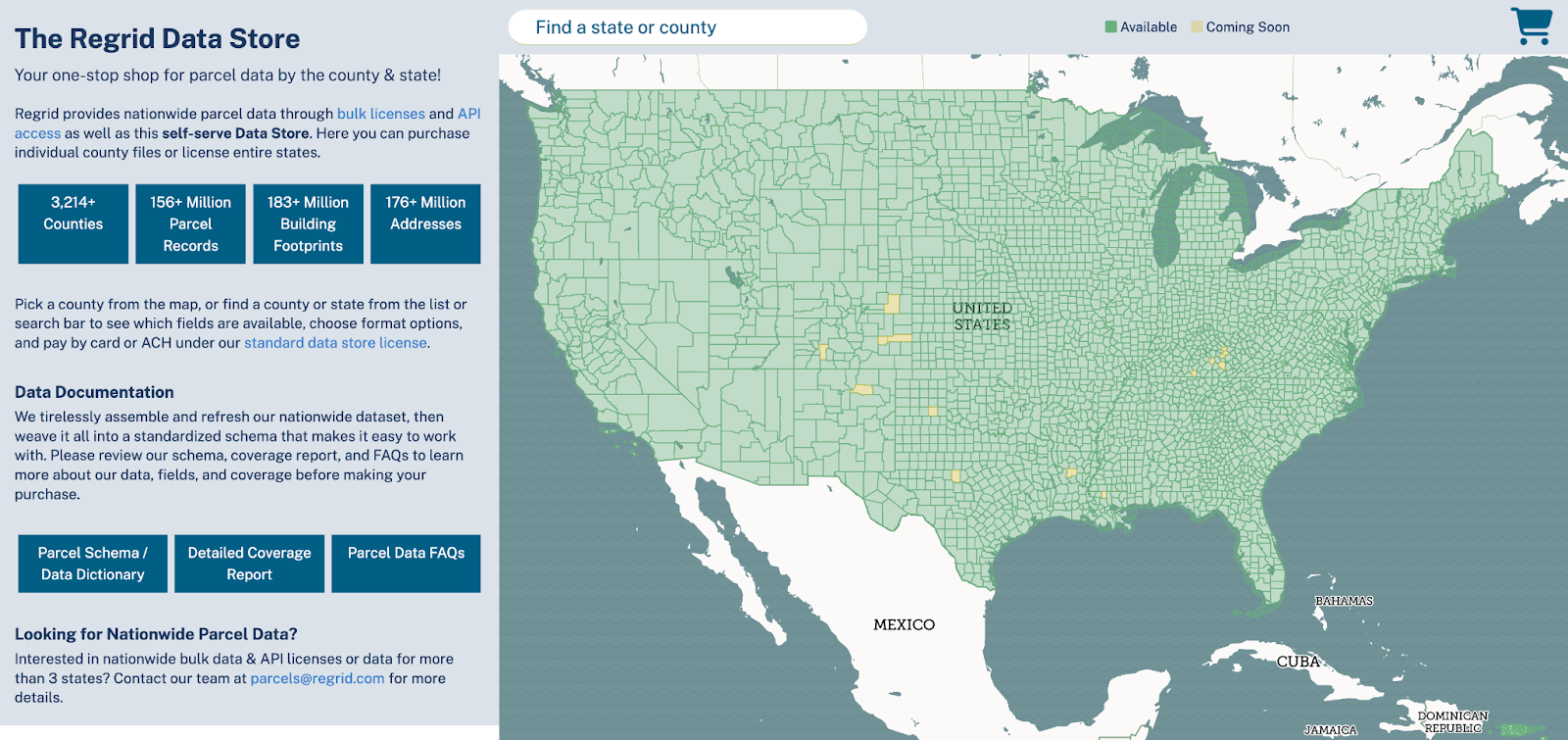
Regrid’s Data Store makes it easy to buy parcel data for almost any county in the United States as well as Puerto Rico. Felt empowers teams to collaborate on maps in real time. With Felt’s intuitive, user-friendly interface, teams can instantly visualize and share geospatial data without the usual complexity. And now it’s easier than ever for those maps to include Regrid parcel data:


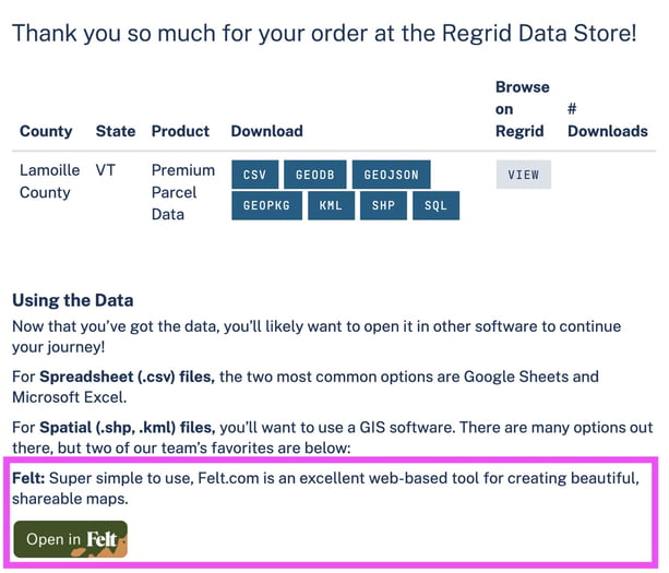
  1. After purchase of a county (or collection of counties) including parcel geometry, users will see the 'Open in Felt' button on their download screen.
  2. Just click the button and Felt will open in a new tab asking you to approve Regrid adding data to a new map in your Felt account (or to create a free Felt account if you don’t already have one).
  3. Once importing is complete you’ll see your new Regrid purchase in Felt and will be able to start working with the data and building your map.

Open in Felt via Regrid Data Store

Open in Felt


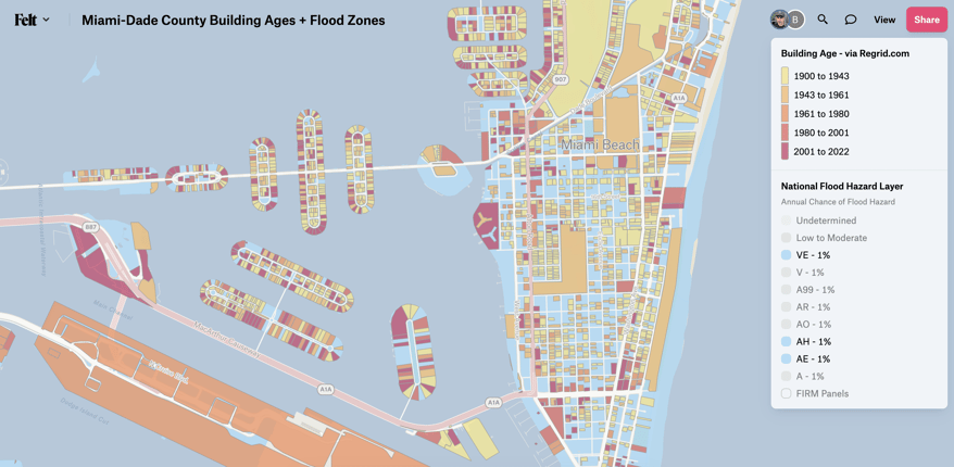
As an example, here’s a map of Miami-Dade County parcel data from Regrid’s Data Store, opened in Felt. In the map, I’ve used Regrid’s Building Age column to create a map showing recent construction in Miami-Dade County alongside FEMA’s National Flood Hazard Layer that is available in Felt’s data layer library. 


It only takes a few minutes to create a map like this and quickly start to get insights out of the powerful combination of Regrid & Felt.


A Map of Building Ages in Miami-Dade County, FL


Regrid Pro 'Open in Felt’

Export Data from Regrid Pro

For subscribers to Regrid Pro, you can use Regrid’s powerful analytical tools to identify parcels with the attributes you care about, and also upload your own parcel-level data to join it to our parcel table. 


  1. Use the Filter tool to isolate the properties you're interested in and then Export to purchase a Shapefile of the parcel geometry and data you need at $0.15 per record.
  2. Once you’ve completed your purchase, the “Open in Felt” button will allow you to open the parcels & data directly in a Felt map.

Export data from Regrid Pro


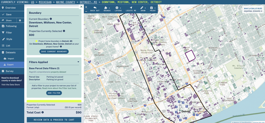
How might you use the feature? Well, here in Detroit, we are considering a major change in our property tax system by transitioning to a land value tax. Say I want to look at how much space our downtown and surrounding commercial areas lose to surface parking lots that are incentivized by low property tax rates for unimproved property. I can use the Regrid Filter tool to isolate Paved and Gravel Parking Lots in Regrid's parcel data, and then purchase the parcels and data in Export to get only those parcels into my Felt map.


Now I can start to tell a story, backed by data, about how much of the city’s prime real estate is given to parked cars instead of people and buildings. Now we can start to look at how a different model of property taxation might change that:

Detroit Surface Parking Lot Map


This is just the first in what we hope are many new ways that Regrid parcels and data can be brought to life in Felt maps.

It’s a milestone in Regrid’s ongoing work to bring to life the fabric of property ownership that we all live on and that shapes the world around us.


We hope this collaboration unlocks new possibilities for exploration, discovery, and innovation for you as it has for us.


Happy Mapping!

Previous Next
logo

(888) 4RE-GRID

  • Contact Us
  • Customer Support
  • Privacy Policy
  • Terms of Use

Subscribe for email updates

Company

  • About Regrid
  • Careers
  • Press

Resources

  • Coverage Map
  • Support Center
  • Reports

Support

  • Parcel Data FAQs
  • Property App FAQs
  • Contact Support Team

Customers

  • Customer Stories
  • Case Studies
  • Non Profit & Academia

Enterprise Solutions

  • Nationwide Land Parcels
  • Parcel & Tiles API
  • Feature Service

Self-Serve Solutions

  • Regrid Property App
  • Shop the Data Store
  • API Monthly Plans