×
See Regrid's NEW Roadway ROW Data in Action!
Regrid logo, registered trademark
  • Enterprise

    Regrid premium parcel data menu icon Premium Parcels

    • US Parcel Data U.S. Parcels
    • Canada Parcel Data Canadian Parcels
    • global-icon Global Parcels

    Spatial add-ons menu icon Spatial Add-Ons

    • Matched building footprints menu icon Matched Building Footprints
    • Matched secondary addresses menu icon Matched Secondary Addresses
    • Standardized zoning menu icon Standardized Zoning
    • Enhanced property ownership menu icon Daily Ownership Updates

    road icon Roadway ROW

    • Roadway polygons icon U.S. Roadway Polygons

    Data access icon Data Access

    • data-store-2 Coverage Map
    • blog_resources_icon-1 Parcel Schema
    • Bulk files icon Bulk Files
    • Feature Service Feature Service
    • api-icon_2025 Parcel API & Tiles
    • API Sandbox icon Interactive API Sandbox
  • Data Store
  • Regrid App
  • Esri Users
  • Resources

    Support menu icon Support

    • Support site menu icon Support Site
    • Tutorial videos menu icon Tutorial Videos

    Content menu icon Content

    • Blog menu icon Blog
    • Customer stories menu icon Customer Stories
    • Reports menu icon Reports

    Programs menu icon Programs

    • academia_menu-icon Nonprofit & Academia
    • Regrid giving menu icon Regrid Giving
  • Contact Us
Contact Us
  • Enterprise

    Premium Parcels

    • U.S. Parcels
    • Canadian Parcels
    • Global Parcels

    Roadway ROW

    • U.S. Roadway Polygons

    Spatial Add-Ons

    • Matched Building Footprints
    • Matched Secondary Addresses
    • Standardized Zoning
    • Daily Ownership Updates

    Data Access

    • Coverage Map
    • Parcel Schema
    • Bulk Files
    • Feature Service
    • Parcel API & Tiles
    • Interactive API Sandbox
  • Data Store
  • Regrid App
  • Esri Users
  • Resources

    Support

    • Support Site
    • Tutorial Videos

    Programs

    • Nonprofit & Academia
    • Regrid Giving

    Content

    • Blog
    • Customer Stories
    • Reports
  • Contact Us

The Regrid Blog

Discover the Latest in Land Parcels & Spatial Data with the Regrid Team!

Regrid Blog

Living In The Map

Categories

  • Announcements
  • Parcel Data Updates
  • Democratizing Data
  • Regrid Updates
  • Product How-To
  • Use Cases
  • Customer & Guest Blogs
  • All About Parcel Data
  • Working at Regrid
  • Regrid 100
  • Reports

All Parcel Data Solutions Available via Regrid Feature Service for Esri-Reliant Enterprises

Team Regrid June 14, 2023

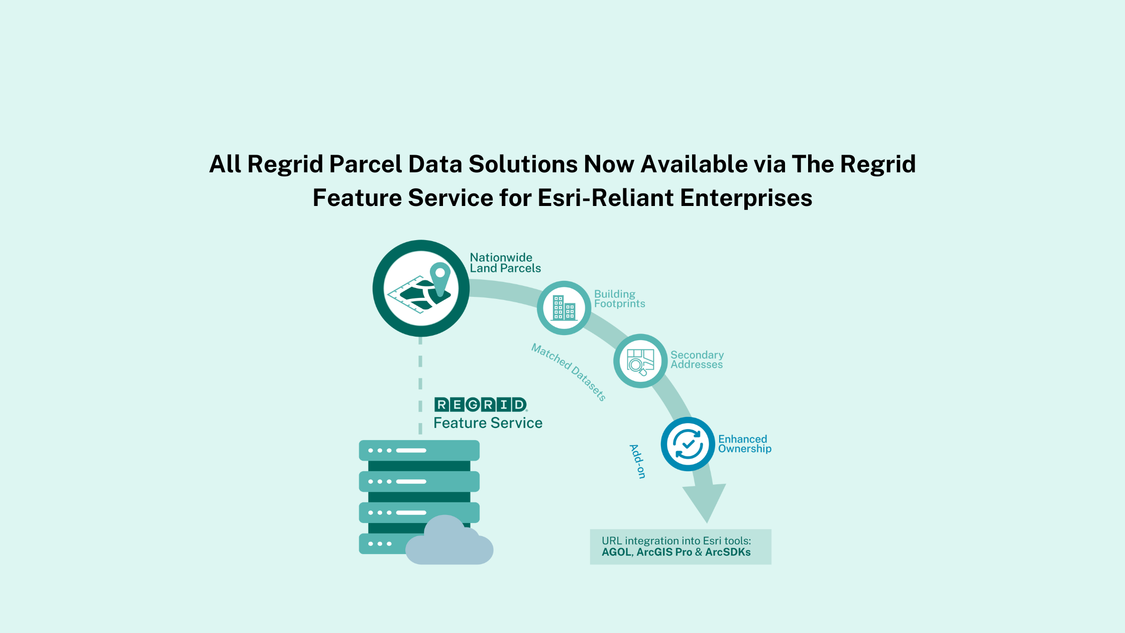
It’s been one year since our official launch of Regrid’s Feature Service and we’re back for an exciting addition to this product!


Regrid’s Feature Service is now available for all our enhanced location datasets including Matched Building Footprints, Matched Secondary Addresses and Enhanced Ownership add-on.


Matched Building Footprints
Over 183 million building footprint geometries, derived from aerial imagery & LIDAR data, and pre-joined to Regrid's nationwide parcel data. Implemented with standardized schemas, and unique identifiers for ease of integration into workflows.
Matched Secondary Addresses
All known (> 179M) addresses in the US, validated to USPS standards, matched with Regrid’s nationwide parcel data & primary situs addresses.
Enhanced Ownership
Parcel data add-on solution that comes with updated ownership records on a daily basis. Gain access to the most current ownership information available including numerous owner names (shared ownership), mailing addresses, and deed ownership information, matched at a parcel level with Regrid’s UUID. 


feature-service-datasets-Graphic


Get our nationwide premium parcel data + these matched datasets straight into your Esri-stack! Simply integrate with a URL for full parcel geometries and matched nationwide data layers. All in one place, right here in the Regrid solution suite.


For enterprises centered on Esri technologies, our Feature Service is compatible with Esri ArcGIS Desktop Pro software, configured web apps hosted on ArcGIS Online, and ArcSDK.


As a user, you can now access full geometries and all attributes we offer from Esri tools, exporting them and converting them into the formats of your choice. 


Esri-reliant customers now have a flexible, faster, and stronger way to integrate Regrid’s parcel data into your projects!


Our Top 5 Reasons For Using Regrid’s Feature Service
  1. Direct integration into your Esri tools and environments for all our enhanced location datasets including Matched Building Footprints, Matched Secondary Addresses and Enhanced Ownership
  2. No data wrangling needed for multiple nationwide datasets joined to our parcels
  3. Compatible with ArcGIS Pro desktop, application configuration tools hosted on ArcGIS Online, and ArcSDKs
  4. Gain control and flexibility of bulk data files directly delivered into the environment of your choice
  5. Fixed, smart & simple pricing structure 

Ready to learn more about the new Matched Datasets with Feature Service? Click the button below to visit the full details on our website or contact a parcel data expert to discuss your specific solutions today!

Learn More About the Regrid Feature Service


Previous Next
logo

(888) 4RE-GRID

  • Contact Us
  • Customer Support
  • Privacy Policy
  • Terms of Use

Subscribe for email updates

Company

  • About Regrid
  • Careers
  • Press

Resources

  • Coverage Map
  • Support Center
  • Reports
  • Regrid Status Page

Enterprise Solutions

  • U.S. Parcels
  • Canada Parcels
  • Parcel & Tiles API

Self-Serve Solutions

  • Regrid Property App
  • Shop the Data Store
  • API Monthly Plans