Regrid logo, registered trademark
  • Enterprise

    Regrid premium parcel data menu icon Premium Parcels

    • US Parcel Data U.S. Parcels
    • Canada Parcel Data Canadian Parcels
    • global-icon Global Parcels

    Spatial add-ons menu icon Spatial Add-Ons

    • Matched building footprints menu icon Matched Building Footprints
    • Matched secondary addresses menu icon Matched Secondary Addresses
    • Standardized zoning menu icon Standardized Zoning
    • Enhanced property ownership menu icon Daily Ownership Updates

    road icon Roadway ROW

    • Roadway polygons icon U.S. Roadway Polygons

    Data access icon Data Access

    • data-store-2 Coverage Map
    • blog_resources_icon-1 Parcel Schema
    • Bulk files icon Bulk Files
    • Feature Service Feature Service
    • api-icon_2025 Parcel API & Tiles
    • API Sandbox icon Interactive API Sandbox
  • Data Store
  • Regrid App
  • Esri Users
  • Resources

    Support menu icon Support

    • Support site menu icon Support Site
    • Tutorial videos menu icon Tutorial Videos

    Content menu icon Content

    • Blog menu icon Blog
    • Customer stories menu icon Customer Stories
    • Reports menu icon Reports

    Programs menu icon Programs

    • academia_menu-icon Nonprofit & Academia
    • Regrid giving menu icon Regrid Giving
  • Contact Us
Contact Us
  • Enterprise

    Premium Parcels

    • U.S. Parcels
    • Canadian Parcels
    • Global Parcels

    Roadway ROW

    • U.S. Roadway Polygons

    Spatial Add-Ons

    • Matched Building Footprints
    • Matched Secondary Addresses
    • Standardized Zoning
    • Daily Ownership Updates

    Data Access

    • Coverage Map
    • Parcel Schema
    • Bulk Files
    • Feature Service
    • Parcel API & Tiles
    • Interactive API Sandbox
  • Data Store
  • Regrid App
  • Esri Users
  • Resources

    Support

    • Support Site
    • Tutorial Videos

    Programs

    • Nonprofit & Academia
    • Regrid Giving

    Content

    • Blog
    • Customer Stories
    • Reports
  • Contact Us

The Regrid Blog

Discover the Latest in Land Parcels & Spatial Data with the Regrid Team!

Regrid Blog

Living In The Map

Categories

  • Announcements
  • Parcel Data Updates
  • Democratizing Data
  • Regrid Updates
  • Product How-To
  • Use Cases
  • Customer & Guest Blogs
  • All About Parcel Data
  • Working at Regrid
  • Regrid 100
  • Reports
Regrid Launches Pay To Download

Regrid Launches Pay to Download: Export Data within The Regrid Property App

Team Regrid April 25, 2023

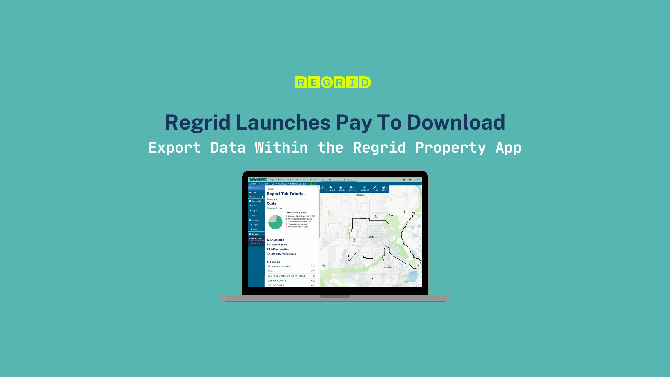
Introducing Pay to Download within The Regrid Property Web App: the ability to download properties of interest in either spreadsheet or spatial formats, right from the Export tab.


Fast, easy way to download Regrid’s parcel data. Buy just what you need, priced per parcel!


Regrid Pro and Team customers can now download parcel data directly from the Regrid Property Web App, priced per parcel. If you want to draw a focus area within your neighborhood or county or run a filter to only download all the vacant properties in your geography, you can do that. Pay for only what you need.

Discover Pay To Download in the Regrid Property App


Now, you can download entire states and counties or precisely filter data in your geography.  The Regrid Property Web App allows you to download and pay for only what you need. Narrow down to just the properties you care about, then export to carry that data into the next part of your workflow.


How does it work?

  • Use the existing tools within the Regrid Property Web App (Filter, Draw Focus Area) to narrow down to properties you want to download.
  • On the Export tab, review your options, choose file format (our standard array of spreadsheet and spatial formats), and check out.


Ready to learn more?

The Regrid Property App places Regrid's massive property data set (over 155+ Million Properties) right at your fingertips. Sign up today for a Regrid Pro or Team account and start downloading!

Sign Up for The Regrid Property App


Note: This feature is only available on the Web version of The Regrid Property App


Regrid is the leading provider of land parcels and location context data for your maps, apps, and spatial analysis. We serve various industries that require nationwide land parcels and spatial data at scale, including real estate, insurance, energy, infrastructure, agriculture, logistics, and government.

Do you have questions? Would you like to evaluate our dataset or work with property data at scale?
Get in touch with our team of data experts at parcels@regrid.com. 

For local and regional parcel data, please visit our self-serve Data Store, where you can instantly download data by county or state.

Previous Next
logo

(888) 4RE-GRID

  • Contact Us
  • Customer Support
  • Privacy Policy
  • Terms of Use

Subscribe for email updates

Company

  • About Regrid
  • Careers
  • Press

Resources

  • Coverage Map
  • Support Center
  • Reports
  • Regrid Status Page

Enterprise Solutions

  • U.S. Parcels
  • Canada Parcels
  • Parcel & Tiles API

Self-Serve Solutions

  • Regrid Property App
  • Shop the Data Store
  • API Monthly Plans