


.png)


.svg)


May 2023 Parcel Data Update
At Regrid, our team of parcel data experts is always working to bring you fresh, accurate parcel data. Check out the latest updates below…
Building Data Nationwide Update: Completed - For Premium tier clients we have updated our nationwide building dataset with new values in the ll_bldg_count and ll_bldg_footprint_sqft columns.
Matched Building Footprint Dataset Update: Completed - As mentioned last month our nationwide dataset of building footprints has been updated and is now available for downloading. This is a major update to the source data used to derive the building footprints with more than 50% of building footprints based on 2021 & 2022 imagery or lidar data. Our 'verse' file indicates the imagery dates for every county. We are also excited that this is the first time that buildings in Alaska and Hawaii have been available.
Matched Building Schema Addition: Completed - For clients that receive our Matched Building product, we have made an addition to the building table schema. We have added a new column named 'ed_largest' that is a flag for the largest building on a parcel.
Matched Addresses Schema Re-Ordering - For clients that receive our Matched Addresses product we will be re-ordering the columns in our exported files to match the order they are listed on our support site: https://support.regrid.com/parcel-data/address-schema. We expect this change to happen in May. No new columns are being added, just a re-ordering of the existing columns to match our published schema linked to above.
Past Data Update Emails - The full archive of our monthly data update emails can be found on our main website: https://regrid.com/blog/tag/parcel-data-updates
Coverage Report - Updated for this month and available here.
A machine-readable version of this list is included in the `verse` table available in all the formats above as well as CSV format for use in spreadsheets. To find the latest updates in verse, sort by 'last_refresh' and use the 'filename_stem' column to identify the file.
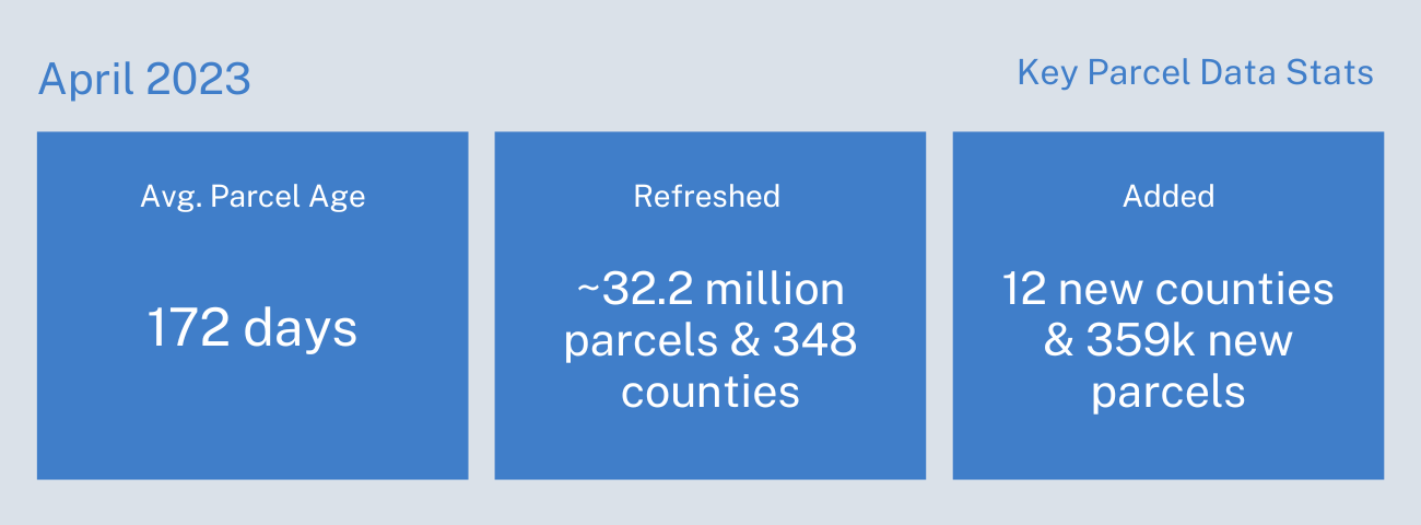
Data refreshed or added in April 2023 and live now:
(Asterisk * indicates newly added county.)
AK - Anchorage, Matanuska-Susitna Borough
AL - Baldwin, Etowah, Jefferson, Madison, Mobile, Morgan
AR - Pulaski
CO - Adams, Arapahoe, Denver, Jefferson, Larimer, Pueblo
CT - Capitol Planning Region, Naugatuck Valley Planning Region
DE - Kent, New Castle, Sussex
FL - Hillsborough, Lee, Miami-Dade, Orange, Palm Beach, Sarasota, Volusia
GA - Clayton, Cobb, DeKalb, Fulton, Paulding, Richmond
HI - Honolulu
ID - Ada, Adams, Bannock, Bear Lake, Bingham, Blaine, Boise, Bonneville, Butte, Camas, Caribou, Cassia, Clearwater, Custer, Elmore, Franklin, Fremont, Gem, Gooding, Idaho, Jefferson, Jerome, Kootenai, Latah, Lemhi, Lewis, Madison, Minidoka, Nez Perce, Oneida, Payette, Power, Shoshone, Teton, Twin Falls, Valley, Washington
IL - DuPage, Jo Daviess*, Lake, McHenry, St. Clair
IN - Hamilton, Lake, Marion, Porter, St. Joseph
KS - Sedgwick, Shawnee
LA - East Baton Rouge, Lafayette, Orleans, Tangipahoa
MA - Essex, Middlesex, Worcester
MI - Jackson, Livingston, Oakland, Saginaw
MN - Anoka, Crow Wing, Dakota, Hennepin, Ramsey, St. Louis, Washington
MO - Clay, Greene, Jefferson, St. Charles, St. Louis, St. Louis City
MS - Harrison, Hinds
MT - Flathead, Yellowstone
NE - Douglas, Lancaster
NM - Bernalillo, Valencia
NV - Washoe
NY - Kings, Orange, Queens, Richmond
OH - Butler, Clermont, Delaware, Franklin, Greene, Hamilton, Licking, Lorain, Mahoning, Medina, Montgomery, Portage, Stark, Summit
OK - Cleveland, Oklahoma, Tulsa
OR - Clatsop
PA - Berks, Bucks, Butler, Cambria, Chester, Delaware, Erie, Lancaster, Lehigh, Luzerne, Monroe, Montgomery, Northampton, Westmoreland, York
SC - Aiken, Anderson, Beaufort, Berkeley, Charleston, Florence, Greenville, Lexington, Richland, Spartanburg, York
SD - Sully*
TN - Davidson, Hamilton, Knox
TX - Bell, Brazoria, Brazos, Denton, Gregg, Hays, Hidalgo, Jefferson, Nueces, Smith, Tarrant, Williamson
UT - Davis, Utah
VA - Bristol, Buckingham, Carroll, Chesterfield, Cumberland, Fairfax, Floyd, Frederick, Giles, Henrico, Lee, Patrick, Prince William, Russell, Scott, Wythe
WA - Clark, Kitsap, Snohomish, Spokane, Thurston, Whatcom, Yakima
WI - Milwaukee
In the current pipeline for updating in May 2023:
Kentucky
Guam
Louisiana
Missouri
Puerto Rico
Indiana
Iowa
In the pipeline for updating in June 2023:
Connecticut
Michigan
New Jersey
Northern Mariana Islands
Virgin Islands
Based on feedback and county challenges, pipeline planning is always subject to change. As always, please contact us if you have any questions about accessing or using the data, if you find issues with any of our data, or you have any comments or questions about our data in specific areas or states. We also love to hear from you about which counties or regions you'd like to see us update next, as it helps inform our planning process.
Thank you for being a part of Regrid!
Best Wishes,
The Regrid Data Team
tech@regrid.com
