


.png)


.svg)


Regrid's Standardized Land Use Codes
The parcel data made available by counties across the US varies widely in how land use is classified (if that information is available at all). Our standardized land use codes describe each parcel across five dimensions (Activity, Function, Structure, Site, and Ownership).
These codes are 4-digit numbers, with the first digit denoting the broadest category, and each successive digit describing the parcel in more detail. For example, in the Activity dimension:
-
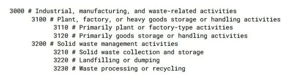
An Activity code of 3000 means 'Industrial, manufacturing, and waste-related activities'.
-
An Activity code of 3100 has one more digit of detail--it still falls under the above description, but it refers to 'Plant, factory, or heavy goods storage or handling activities'.
-
An Activity code of 3120 means 'Primarily goods storage or handling activities'--still industrial in nature, and related to plant, factory, or heavy goods storage or handling, but much more specific!
In the image below, where codes are indented to show their hierarchy, you can see how an Activity code of 3120 is just one of several different codes (e.g. 3110, 3120, 3210, 3220, 3230) at the same level of specificity (three digits):
When you expand this potential for specificity across five dimensions, each intended to describe an aspect of the land use for a particular parcel, you can see how useful Regrid's standardized land use codes can be to identify land used for general or specific purposes.
Our standardized land use codes are derived from the Land-Based Classification System (LBCS), a method devised by the American Planning Association. Activity describes the actual human activities that take place on the parcel, while Function describes the broader economic or social use the parcel serves. Structure and Site describe the type of structure on a parcel and, independently, whether the parcel is developed or not. Ownership describes whether the owner of the parcel is a public or private entity.
The five-dimension approach gives a sense of what is actually there for any given parcel, and we fill as many of the five dimensions as we can when we apply our standardized land use codes. This work is done manually, county by county, matching each place's assessor-provided land use information (where available) to the applicable codes for each dimension.
For example, a parcel that is used as a parking lot for a public school would be encoded like this using our system:
-
Activity: 5210 (Vehicular parking, storage, etc.)
-
Function: 6100 (Educational services)
-
Structure: 5200 (Automobile parking facilities)
-
Site: 5300 (Developed site with roads, train tracks, and other linear structures)
-
Ownership: 6100 (Nonprofit educational)
Whereas, in a traditional single-dimension system, a choice would have to be made between classifying that same school parking lot as simply "parking" or "educational", or possibly even just "public property".
In Regrid's entire nationwide dataset of more than 152 million land parcel records, two-thirds of all parcels have a standardized land use code for Activity and Function. We continually add new places and fill in codes for existing ones. You can stay up to date on which places have standardized land use codes using our coverage report.
In addition to the standardized land use codes, our data also includes human-readable '_description' fields for each dimension. To use the same example from earlier, an 'lbcs_activity' value of 3120 would have an 'lbcs_activity_description' value of 'Primarily goods storage or handling'. We keep the standardized land use codes and text descriptions separate to allow for easier processing and sorting of our data.
Users of Regrid's data and the mapping platform can perform queries to find patterns across the dataset, or to count certain types of parcels.
Our Border Parcels project shows how our standardized land use codes can be used to generate insights into how land is used across areas of interest that span multiple states and counties, each of which provided entirely separate and incompatible land use data.
Likewise, finding and mapping all the residential parcels in a city could help with understanding and tracking the spread of disease outbreaks like the current COVID-19 pandemic. If you are a local government or a fellow mapping and data company that could use parcel data to push forward your study, outreach efforts, and research on COVID-19, or if you have questions about LBCS in general, please contact us at parcels@regrid.com, or check out the parcel data FAQ.
Happy Mapping!
Ray Visser | Regrid GIS Analyst
Have questions? Want to evaluate our dataset? Get in touch with our team at parcels@regrid.com.
Learn more about our Nationwide Parcel Data, our schema, pricing and coverage here.
Regrid is an industry-leading property data and location intelligence company. We serve an array of industries that require land parcels and spatial data at scale, including real estate, insurance, energy, infrastructure, agriculture, logistics, and government.
