


.png)


.svg)


January Parcel Update 2022
Dear Friends of Regrid Parcel Data and Regrid.com,
A detail of updates in December of 2021 and the upcoming pipeline is below.
42 new counties coming soon
We are currently processing and standardizing 42 new counties. They will be available to nationwide bulk and API customers by the end of January. You will hear all about them in our February parcel update.
Changes to county table "Layer Names"
Some spatial file formats support a "layer name" for use by software applications. In some software applications, layer names with a dash character, " - " require an additional step during processing. We will be updating our exports to convert dashes, to underscore " _ " characters in layer names starting in January of 2022. Underscore characters are better supported in software applications. Please let us know if you have any feedback or suggestions related to this change.
Loveland Parcel Record Schema changes coming!
We are adding more attribute columns to our Parcel Record Schema in the next 30 - 40 days. We will provide updates in these monthly bulk data emails when they are fully added. More details on these fields can be found at the Data Dictionary listed below, but the shortlist is: homestead_exemption, alt_parcelnumb1-3 (total of 3 new columns), parcelnumb_no_formatting, assessor_data_date, township, section, range, census_school_district. We would love any feedback on these proposed attributes you might have.
USPS Vacancy, Residential indicators: Unchanged from last month, next update in January.
Coverage Report: Updated for this month and available here.
A machine-readable version of this list is included in the `verse` table available in all the formats above as well as CSV format for use in spreadsheets. To find the latest updates in verse, sort by 'last_refresh' and use the 'filename_stem' column to identify the file.

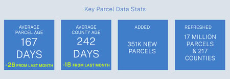
Data refreshed or added:
(Asterisk * indicates newly added county.)
CA - Colusa, Monterey, Shasta
CO - Ouray, Pitkin
FL - Alachua, Baker, Bay, Bradford, Brevard, Broward, Calhoun, Charlotte, Citrus, Clay, Collier, Columbia, DeSoto, Dixie, Escambia, Flagler, Franklin, Gadsden, Gilchrist, Glades, Gulf, Hamilton, Hardee, Hendry, Hernando, Highlands, Hillsborough, Holmes, Indian River, Jackson, Jefferson, Lafayette, Lake, Lee, Leon, Levy, Liberty, Madison, Manatee, Marion, Martin, Miami-Dade, Monroe, Nassau, Okaloosa, Okeechobee, Osceola, Palm Beach, Pasco, Pinellas, Polk, Putnam, Santa Rosa, Sarasota, Seminole, St. Johns, St. Lucie, Sumter, Suwannee, Taylor, Union, Volusia, Wakulla, Walton, Washington
IA - Decatur
ID - Benewah
IL - Adams, Bond, Boone, Bureau, Champaign, Christian, Clark, Clay, Clinton, Coles, Cook, Crawford, Cumberland, De Witt, Douglas, DuPage, Edgar, Fayette, Ford, Franklin, Fulton, Grundy, Hamilton, Hancock, Henderson, Henry, Jackson, Jasper, Jefferson, Jersey, Kane, Kendall, Lake, LaSalle, Lawrence, Lee, Logan, Macon, Macoupin, Madison, Marion, Marshall, Massac, McDonough, McHenry, McLean, Menard, Monroe, Morgan, Moultrie, Peoria, Perry, Randolph, Rock Island, Sangamon, Schuyler, Shelby, Stark, St. Clair, Stephenson, Vermilion, Warren, White, Whiteside, Will, Williamson, Winnebago, Woodford
MI - Barry, Calhoun, Cass, Chippewa, Clare, Clinton, Delta, Gladwin, Gratiot, Huron, Isabella, Mackinac, Mecosta, Sanilac, Schoolcraft, Shiawassee, St. Joseph, Wayne
MS - Adams, Alcorn, Amite, Attala, Benton, Bolivar, Calhoun, Chickasaw, Clarke, Clay, Coahoma, Copiah, Covington, Forrest, Grenada, Hancock, Harrison, Holmes, Itawamba, Jackson, Jasper, Jefferson, Jones, Lafayette, Lamar, Lauderdale, Lawrence, Leake, Leflore, Lowndes, Madison, Marion, Monroe, Montgomery, Neshoba, Newton, Noxubee, Oktibbeha, Panola, Pearl River, Pike, Pontotoc, Prentiss, Quitman, Rankin, Scott, Simpson, Smith, Stone, Sunflower, Tate, Tippah, Tishomingo, Tunica, Union, Walthall, Warren, Wayne, Webster, Winston
WI - Milwaukee
In the current pipeline for updating in January 2022:
Hawaii
Pennsylvania
Washington
District of Columbia
In the pipeline for updating in February 2022:
California
Oregon
Based on feedback and county challenges, pipeline planning is always subject to change. As always, please contact us if you have any questions about accessing or using the data, if you find issues with any of our data, or you have any comments or questions about our data in specific areas or states. We also love to hear from you about which counties or regions you’d like to see us update next, as it helps inform our planning process.
Thank you for being a part of Regrid!
HAPPY MAPPING!
THE REGRID DATA TEAM
tech@regrid.com

Make sure you've downloaded our EOY Nationwide Parcel Data Report.
We looked back at 2021 and all the incredible improvements we made to our nationwide parcel dataset with regards to currency, coverage and completeness.
We put those KPIs and stats into this nifty little report. Download today and reach out to us if you have any questions
