×
Regrid 100: The First-Ever 100% US Land Parcel Coverage Map
Regrid logo, registered trademark
  • Enterprise Solutions

    Regrid parcel data Regrid Parcel Data

    Bulk files delivered in the format your business needs.

    • parcel -data Nationwide Parcel Data
    • matched building footprints menu icon Matched Building Footprints
    • matched secondary addresses menu icon Matched Secondary Addresses
    • enhanced ownership menu icon Enhanced Ownership

    feature service menu icon Regrid Feature Service

    Get data delivery straight into your Esri-stack, no custom integration required.

    regrid api menu icon Regrid API

    Integrate parcel boundaries & records into your app, SaaS, or map.
    • Parcel and Tiles APIcon Parcel & Tiles API
    • typeahead api icon Typeahead API
  • Self Serve Options

    Regrid Property App menu icon Regrid Property App

    Take Regrid property data wherever you go - available for web, iOS, & Android.

    data-store-2 Shop the Data Store

    Instantly download parcel geometries & associated records, by county and state.

    self-serve parcel api menu icon API Monthly Subscriptions

    Sign up and try this nationwide parcel API, free for 7 days.

    api sandbox icon Interactive API Sandbox

    Explore the API Sandbox with complete feature access to 7 counties plus Puerto Rico.
  • Markets

    Regrid for Broadband Market Broadband

    Regrid for data science Data Science

    Esri environments Esri Users

    Parcel data for green initiatives Sustainable Initiatives

    Parcel data for real estate Real Estate

    Parcel data for nonprofit and academia Nonprofit & Academia

    Regrid's Data With Purpose program - propose your own budget to access land parcel data. 

    Plus sign icon Your Business or Organization

    Regrid’s data spans all industries needing land insight.
  • Resources

    support menu icon Support

    Access documentation & support materials to learn about Regrid data.
    • Support site resource icon Support Site
    • tutorial videos resources icon Tutorial Videos
    • parcel data faqs resources icon Parcel Data FAQs
    • property app faqs Property App FAQs
    • coveragemap_resources_icon Coverage Map
    • land use codes menu item Land Use Codes
    • vacancy data menu icon Vacancy Data

    content resources menu icon Content

    Dive into Regrid's world of land parcels & learn about location intelligence.
    • blog resources icon Blog
    • webcasts resources icon Webcasts
    • reports resources icon Reports
    • podcast resources icon Living In The Map

    customers resources icon Customers

    Hear what our customers say have to say & see how they use Regrid data.
    • testimonials resources icon Testimonials
    • Case Studies resources icon Case Studies
  • Contact Us

    Contact a parcel data expert menu icon Contact A Parcel Data Expert

    Contact Regrid parcel data experts to learn more about our offerings.

    Customer Support menu icon Customer Support

    Contact our customer support team & get the help you need.

    megamenu nav image Press & Media Inquires

    Find the information you need & get in touch with our marketing department.
  • Go To Map
Go To Map
  • Enterprise Solutions

    Regrid Parcel Data

    • Nationwide Parcel Data
    • Matched Building Footprints
    • Matched Secondary Addresses
    • Enhanced Ownership

    Regrid Feature Service

    Regrid API

    • Parcel & Tiles API
    • Typeahead API
  • Self Serve Options

    Regrid Property App

    Shop the Data Store

    API Monthly Subscriptions

    Interactive API Sandbox

  • Markets

    Broadband

    Data Science

    Esri Users

    Sustainable Initiatives

    Real Estate

    Nonprofit & Academia

    Your Business or Organization

  • Resources

    Support

    • Support Site
    • Tutorial Videos
    • Parcel Data FAQs
    • Property App FAQs
    • Coverage Map
    • Land Use Codes
    • Vacancy Data

    Content

    • Blog
    • Webcasts
    • Reports
    • Living In The Map

    Customers

    • Testimonials
    • Case Studies
  • Contact Us

    Contact A Parcel Data Expert

    Customer Support

    Press & Media Inquires

  • Go To Map

The Regrid Blog

Discover the Latest in Land Parcels & Spatial Data with the Regrid Team!

Regrid Blog

Living In The Map

Categories

  • Announcements
  • Democratizing Data
  • Regrid Updates
  • Parcel Data Updates
  • Product How-To
  • Use Cases
  • Customer & Guest Blogs
  • All About Parcel Data
  • Working at Regrid
  • Regrid 100
Regrid Product Updates

Regrid Updates - Mobile App, API, and Esri UC Recap

Team Regrid August 23, 2022

Download the Regrid Mobile App! button


We are back with some interesting product and event updates, in case you were wondering about what’s been brewing in the Regrid world.
Without further ado, let’s jump right into them.

Regrid Mobile App - New Location Intelligence Tools for Pro users
The Regrid mobile app just got better. We are pushing some of our most popular Pro features and tools to our mobile app this week. 
Which ones, you ask?

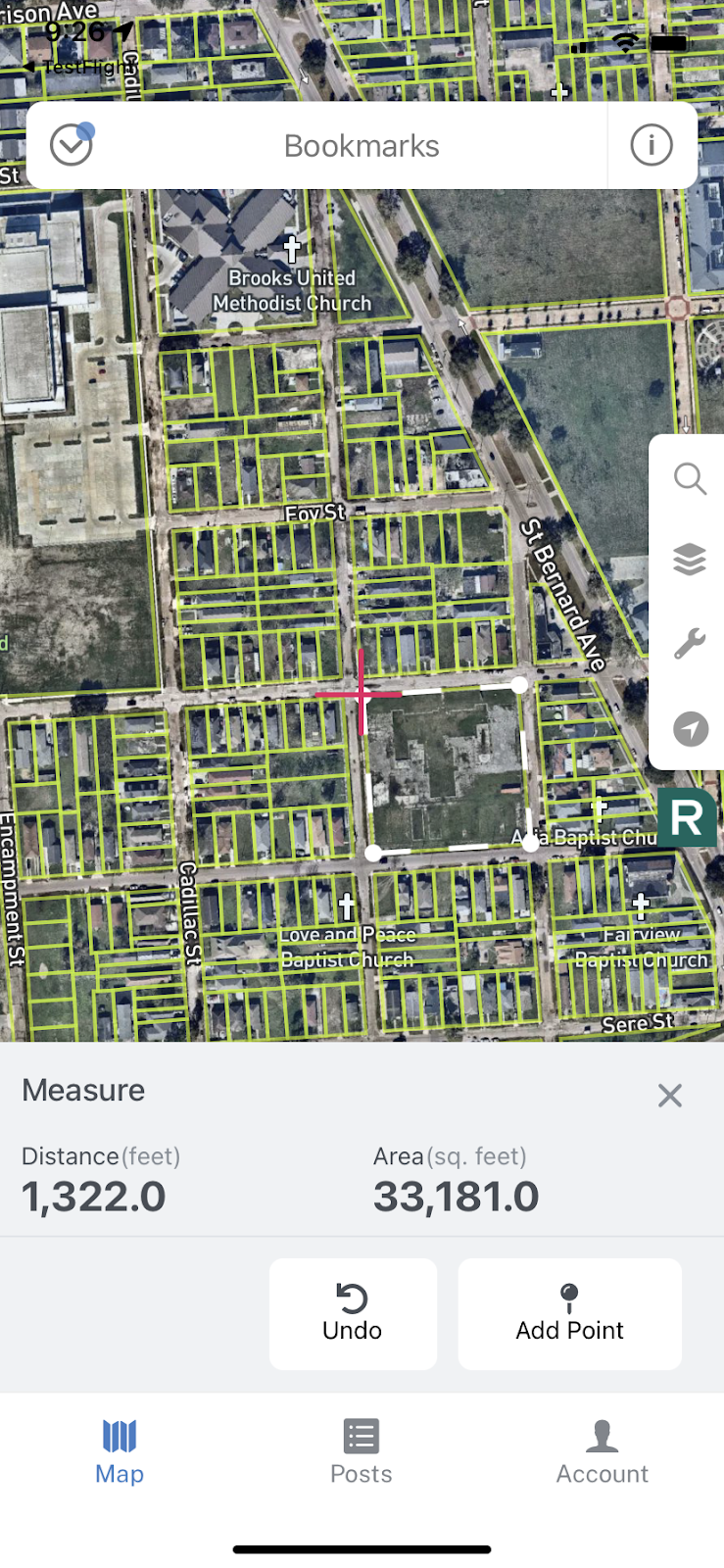
  1. Measure Tool - The ability to measure distances is one of our most-requested features for the app, so we implemented it! Our new tool allows you to measure path distance and area so that you can understand the lay of your land better from your phone or other mobile devices.
  2. Find the coordinates of a point - With our dynamic lat/long calculator, you can find the exact coordinates of a point anywhere in the country. So, know your geography & geometry at all times.


A screenshot of the new lat/lon tool in the Regrid Mobile App A screen shot of the new measure tool on the Regrid Mobile App


These are only the first set of mobile app updates that we rolled out. There’s a slew of massive updates coming up shortly! If you use our mobile app and would love to get early beta access to some of the updates we are making to the app right now, please let us know by providing your consent on this form and our team will get in touch with you.

Learn more about the Regrid mobile app - download the app if you haven’t and start connecting with land today.

Download the Regrid Mobile App


Regrid API -Schema-only fields
As you are aware, the Regrid data team works tenaciously all year round to weave all the data we get from counties into a normalized, standardized format using the Regrid parcel schema. By doing so, we ensure that the disparate raw data we get from the counties are standardized at a nationwide level and hence can be consumed at scale, no matter the geography.

However, every now and then, we get additional fields from some counties that are not included in our standardized schema and are typically not available to us from all counties. We call these columns ‘Custom columns’ and ‘non-schema’ fields and we pass them along in our data as-is in their raw form as received from the county.

Many of our customers love receiving the non-standardized custom columns, while some of our customers also prefer the greater flexibility and scalability of working with schema-only fields for their ETL workflows. To ensure this flexibility, we now provide a boolean flag return_custom to our API customers to either remove the non-standardized custom fields from their API responses in order to get our standardized schema-only fields or retain the custom columns in the responses, based on the preference of their data team and ETL setup.


We’ve had a similar solution for our bulk data customers for a while now and with this update, our API customers can enjoy the ability to remove custom fields as needed from their API responses.

Reach out to us if you want to try our Parcel API & tileserver for your use cases!

Email us at parcels@regrid.com button


County Coverage Improvements
If you have been following us closely, then you might have noticed that we have been aggressively improving our county coverage & our parcel age consistently for the past few years but more so in 2022 itself. 

As of today, we have added 59 new counties this year alone bringing our total county count to 3,184+.

And our current parcel age is down to 165 days!

The Regrid coverage map as of August 22, 2022


A Reflection on the Esri User Conference Expo
In early July, the Regrid Team exhibited at the Esri User Conference Expo, including our CEO, CDO, and CRO. 

As a certified Esri partner, we also showcased our newly launched Esri-compatible Feature Service at the event. Needless to say, the event has been a big milestone for us here at Regrid.

Catch a quick glimpse & some amazing highlights from the event in the words of our very own CEO - Jerry Paffendorf.

Reflections and photos from the Esri User Conference by CEO & co-founder Jerry Paffendorf


We dove into Q3 head first - from the Esri User Conference to launching the Regrid Feature Service and the above product updates… and we have no plans of slowing down.

Until then,

Happy Mapping!
 Team Regrid

Regrid TM


Previous Next
logo

(888) 4RE-GRID

  • Contact Us
  • Customer Support
  • Privacy Policy
  • Terms of Use

Subscribe for email updates

Company

  • About Regrid
  • Careers
  • Press

Resources

  • Coverage Map
  • Support Center
  • Reports

Support

  • Parcel Data FAQs
  • Property App FAQs
  • Contact Support Team

Customers

  • Customer Stories
  • Case Studies
  • Non Profit & Academia

Enterprise Solutions

  • Nationwide Land Parcels
  • Parcel & Tiles API
  • Feature Service

Self-Serve Solutions

  • Regrid Property App
  • Shop the Data Store
  • API Monthly Plans