

.png)




Parcel data is a powerful resource for many in academia and nonprofits, but it is one that often comes with an inaccessible price tag.
Welcome to "Data With Purpose" – a program designed to make Regrid's nationwide land parcel data available to everyone from graduate students and university data labs to local community organizations and national nonprofits.
Designed to provide a flexible approach to parcel data licensing, Regrid’s Data With Purpose empowers researchers, academics, and nonprofits to access our extensive data catalog at a cost that aligns with your budget. Tell us about your use case and propose the budget, and we’ll work with you to find a data solution that fits. We're devoted to ensuring that financial constraints never become a barrier to progress and innovation.
Whether you're an academic working on a specific project or a nonprofit seeking data for daily operations, we offer two types of licenses tailored to your needs. Opt for a 'Project License' for single-project use or choose a 'General Use License' for broader organizational utilization.
Apply now to harness the transformative potential of Regrid's parcel data through the Data With Purpose program.
Data With Purpose allows researchers like those at the PLACES lab to gain new insights related to nationwide land conservation.
Want to see other examples of our parcel data being put to work?
%20(1)%20(1).jpg?width=400&height=240&name=F1.large%20(1)%20(1)%20(1).jpg)
Land value per hectare can be used for predicting the cost of land conservation.


.png)


Applicants do not need to have official nonprofit status and can include researchers, academics, governments, and community organizations who are purely using the data to enlighten or improve a situation in the world, and not for business purposes.
The Regrid team loves working with people and projects that directly assist communities or advance our shared understanding of land and geographies -if that sounds like you, go ahead and apply!
Regrid grew up in the civic technology, open data, and community advocacy scenes of Detroit, Michigan circa 2010, where we were founded as Loveland Technologies.
We know that some of the most important projects in the world are underfunded and that great data is needed by nonprofits, academics, governments, and advocates that don’t always have large or consistent budgets.
When the Michigan Geological Survey’s Triage Project needed to validate and quality control the locations of hundreds of thousands of water wells across the state of Michigan – a critical part of PFAS contamination monitoring and remediation – they turned to Regrid’s Data With Purpose program and Regrid’s Esri Feature Service to supercharge their effort.
“Previously, we had to manually and visually assess the plotted location of each individual well point. Now, we are able to process up to 60% of a given county’s well data using a Michigan Geological Survey-developed ArcPython script which depends on Regrid parcel data and the Esri-compatible Regrid Feature Service. This has dramatically increased our productivity.”
Evie Murgia
Project Manager,
The Triage Project
"How do you conserve a healthy environment - forests, species, open space - with limited funding under a rapidly changing climate? It’s a phenomenal challenge! Regrid’s “Data With Purpose” program has allowed us, for the first time, to map potential benefits and costs of land conservation actions for (almost) every parcel in the country. It's an incredible novel and valuable foundation for scientific analysis and decision-making that we could only have dreamed of five years ago."

Christoph Nolte
Assistant Professor,
PLACES Lab (Boston University)
The Trust for Public Lands, a national nonprofit, uses Regrid's Premium Schema parcel data to map existing carbon stocks and areas with higher annual emissions. They use our bulk data for their Carbon Conservation Map and help them discover what and where the threats to these carbon-rich landscapes are.
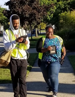
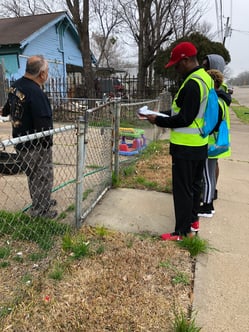
The Quicken Loans Community Fund, in partnership with the United Community Housing Coalition, sent teams of more than 400 Detroiters to visit every home at risk of tax foreclosure in the city of Detroit - 60,000 households. At each house, surveyors distributed foreclosure prevention information and gathered data using the Regrid Property App.
"Over the past two years, I have had an opportunity to use and become familiar with the Regrid App. I can honestly say that it made canvassing the neighborhoods a million times easier, and much more efficient and effective! Being able to tap on an address, zoom in on a particular house or street, and store and track the data over a period of time enabled me and my team to keep meticulous records that were essential to our job success! Real-time updates, as well as phone support, helped a great deal whenever there were any issues. Keep up the good work. It definitely helps the ‘little folks’ out in the field every day."
Anthony Brinson
NeighborToNeighbor
The Western Reserve Land Conservancy surveyed every parcel in Cleveland in 2015 using the Regrid Property App. In 2018, they revisited more than 70,000 parcels on the east side, in order to see the impact of demolition funding during the past three years and to analyze change over time in the hardest-hit neighborhoods.

In September of 2018, The Real Estate Council, Regrid, and other partners began a project called Community Driven Growth with funding from the JPMorgan Chase Pro Neighborhoods Grant Program. The goal was to work in three Dallas neighborhoods considered at risk of gentrification and to pilot a model of what resident and community-driven growth looks like. Regrid facilitated a large resident surveying project. This surveying component was intended to supplement other data being collected by the Community Driven Growth partners regarding community preferences, needs, and concerns.
"One of the benefits of working with land parcel data from Regrid is the ability to take other forms of geospatial data and identify which parcels they affect or interact with. Oftentimes, geospatial data comes as points of interest (POI) which show where something happened, or where a data point is located, but not what property the data is associated with, nor that property’s underlying ownership, assessment, and use information."
Francis Russell
Graduate Student![]()
"The land use data obtained from Regrid was instrumental for my work. It allowed me to document with great detail the activities happening in each neighborhood. By leveraging the standardized land use classification system, I was able to compare the land use of parcels across different locations throughout the US."
Arianna Salazar Miranda
PhD Candidate
Researchers supplemented open-access source data with parcel polygon data from Regrid through our Data With Purpose program. They then matched this with additional data bases, with a median county-level success rate of 98.2% and a mean of 95.5%.
Climate Central's deep data analysis report on the sinking tax base & implications of rising temperatures across the country.
This analysis delivers an assessment of sea level rise impact on the tax base of hundreds of coastal U.S. counties—specifically, the potential loss of taxable properties caused by shifting tidal boundaries. To calculate the taxable value of affected parcels and buildings, Climate Central used standardized land parcel data from Regrid.
If Data With Purpose isn't for you, don't worry - there are other ways to access our parcel data!
Present property data and boundaries in your application with Regrid Parcel API.
Parcel APIGet parcel data delivered straight into your Esri-stack with Regrid's Feature Service.
Feature Service