


.png)


.svg)


Better Help Tools, Better Features, Better Data & Better Landgrid.com
Howdy people of Landgrid & soon to be people of Landgrid!
If you have been following us these past few months, you know that we have been adding lots of improvements & new functionality to our suite of products.
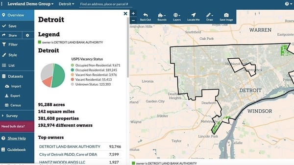
Our most recent updates were the USPS - Vacancy & residential data that we added both to our bulk parcel dataset & to our Landgrid Mapping Platform.
Along the lines of making our platform better & easier to use & navigate, we recently conducted a UX study with a host of new users, power users & GIS users to understand how usable our product is.
A direct result of that are the new help tools to navigate & manage your projects better on the Landgrid platform. We have always had help tools & documentation on our platform.
But with these tooltips, we want to take things a step further to make your experience go smoother on the platform. We essentially want to make sure that you have the tools you need to make the most out of our fully loaded site & mainly so you never feel lost on how to use the platform.
The best thing about these help tools are that they are available to you, at all times on demand! You can toggle to turn them on when you need help navigating the site & turn them when you don’t.
Apart from the help tools, we have added some other functionality into the platform that are also a direct result of us listening to our customers. We took many of your requests and incorporated some of there here. I know there are many more requests & rest assured - We will get to them & add those to our product roadmap in the coming months.
So here’s a quick snapshot into everything that we have added to the platform to make it more usable:
1. Onboarding Tooltips:
- To turn on tooltips, you can select “Show Help” on the left hand panel or under the “?” icon drop down and it will instantly bring up the tips for each of our many features.
- Click on the “?” on the tip and it will open up a window describing the feature to you, along with links to the relevant articles on our product documentation for a deeper dive into the feature.
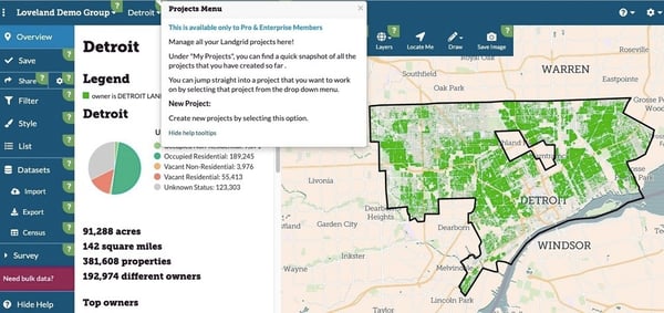
- To turn the tooltips off, simple select “Hide Help” on the left hand panel, or on the tooltip window itself or under the “?” drop down.
- OR Simple press the escape key “esc” on your keyboard to exit the help tools.
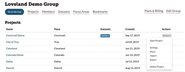
2. Project Settings:
- We heard you! We’ve had users asking for an easy way to manage & edit projects from one central location. You can now do that from your dashboard page.
- Select “Actions” drop down as shown below and you should be able to edit project settings, delete, import or export straight from the Dashboard.
- We also added “Date Created” and datasets associated with your project to your dashboard. So now you can see all the details that you need to know about your projects right here
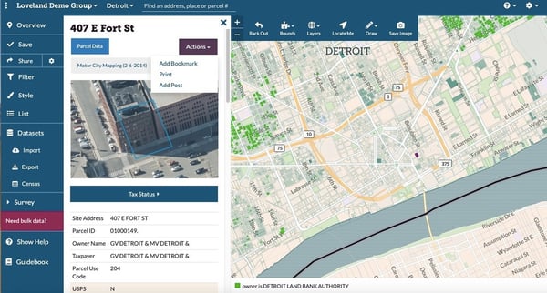
3. Printable PDF’s of parcel page & attributes:
- We work with a lot of landbanks & municipalities and they have been asking us to build a way to print individual parcel records or survey records as PDF’s.
- And now its available on Landgrid.com!
- How to access it, you ask? Easy - Navigate & zoom into the parcel you want to print.
- When the parcel page loads up, click on the “Actions” dropdown and you will see 3 options there:
- Bookmark - Which is now part of the dropdown.
- Print - To print the entire parcel record as a PDF
- Add Post - If your project is part of a survey, you can use the “Add Post” function to update the information for this parcel.
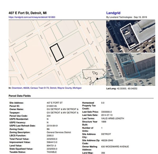
The resulting Parcel PDF looks like this:
4. Few other improvements:
- We are in the process of adding building footprints to our data & as a map layer on our platform. We want to give you a teaser of what that would look like. For Pro & above users, go to “Layers” & select Ohio Buildings and you can see the building footprints render on the map. Soon we will have this available nationwide.
- “Esc” key can be used to turn off some of our other features as well - like the draw & measure tool. This was a request from one of our users & we made it happen.
- Better accessibility on the platform - Turning on & off of layers & bounds is more intuitive & usable now.
Well… That’s a lot of work & improvements from our team. Kudos to our amazing CTO Larry Sheradon & our data team for keeping us on our toes & making sure that we are constantly improving!
We are not done yet! There is more coming in 2019 & stay tuned with us to learn more!
