regrid_tm_forest
Sign In
  • Products ⌄

    Regrid premium parcel data menu icon Premium parcels

    • global-icon Global parcels
    • US Parcel Data U.S. parcels
    • Europe-icon-navigation European parcels
    • Canada Parcel Data Canadian parcels
    • map-location-pin-regrid-icon U.S. coverage map

    Spatial add-ons menu icon Spatial add-ons

    • Matched building footprints menu icon Matched building footprints
    • Matched secondary addresses menu icon Matched secondary addresses
    • Standardized zoning menu icon Standardized zoning
    • Enhanced property ownership menu icon Daily ownership updates
    • roadway-row-icon_2025-1 U.S. roadway polygons

    Data access icon Delivery methods

    • Bulk files icon Bulk files
    • Feature Service Feature service
    • api-icon_2025 Parcel API and tiles
    • API Sandbox icon Interactive API sandbox
  • Industries ⌄

    industries-we-serve Industries we serve

    • aec-navigation-icon Architecture, engineering, and construction (AEC)
    • re-navigation-icon Real estate
    • gov-navigation-icon Government
    • ag-navigation-icon Agriculture
    • energy-navigation-icon Renewable energy and utilities
    • telco-navigation-icon Broadband and telecommunications
    • insurance-navigation-icon Insurance and finance
    • ai-ml-navigation-icon AI and machine learning
    • transportation-navigation-icon Transportation and logistics
  • Data store
  • Property App
  • Esri users
  • Resources ⌄

    Support menu icon Support

    • Support site menu icon Support site
    • Tutorial videos menu icon Tutorial videos
    • blog_resources_icon-1 Parcel schema
    • Regrid icon Sign into the Regrid Property App

    Content menu icon Content

    • Blog menu icon Blog
    • Customer stories menu icon Customer Stories
    • Reports menu icon Reports
    • data-store-2 Coverage map

    Programs menu icon Programs

    • academia_menu-icon Nonprofit & Academia
    • Regrid giving menu icon Regrid Giving
    • dwp-navigation-icon copy Data with Purpose

    shop icon Shop

    • merch_icon_2025 Regrid Merch
  • Contact us
Contact us
  • Products ⌄

    Premium parcels

    • Global parcels
    • U.S. parcels
    • European parcels
    • Canadian parcels
    • U.S. coverage map

    Delivery methods

    • Bulk files
    • Feature service
    • Parcel API and tiles
    • Interactive API sandbox

    Spatial add-ons

    • Matched building footprints
    • Matched secondary addresses
    • Standardized zoning
    • Daily ownership updates
    • U.S. roadway polygons
  • Industries ⌄

    Industries we serve

    • Architecture, engineering, and construction (AEC)
    • Real estate
    • Government
    • Agriculture
    • Renewable energy and utilities
    • Broadband and telecommunications
    • Insurance and finance
    • AI and machine learning
    • Transportation and logistics
  • Data store
  • Property App
  • Esri users
  • Resources ⌄

    Support

    • Support site
    • Tutorial videos
    • Parcel schema
    • Sign into the Regrid Property App

    Programs

    • Nonprofit & Academia
    • Regrid Giving
    • Data with Purpose

    Content

    • Blog
    • Customer Stories
    • Reports
    • Coverage map

    Shop

    • Regrid Merch
  • Contact us

The Regrid Blog

Discover the Latest in Land Parcels & Spatial Data with the Regrid Team!

Categories

  • Announcements
  • Parcel Data Updates
  • Democratizing Data
  • Regrid Updates
  • Product How-To
  • Use Cases
  • All About Parcel Data
  • Customer & Guest Blogs
  • Working at Regrid
  • Regrid 100
  • Reports

Welcome to the Regrid Parcel Data Store

Sahana Murthy March 4, 2020

A short video demo of how to purchase data by the county & state in our Data Store


Welcome to the Regrid (previously Landgrid by Loveland) Data Store – Your One-Stop Shop for all things parcel data! 

Ever need to download data from Landgrid to use in another program?

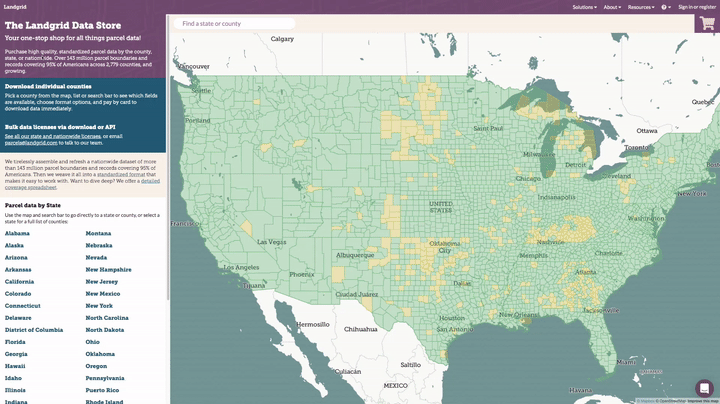
You can now visit app.regrid.com/store to purchase parcel data for any individual county in the country, either as a spreadsheet or as the full shapefile with parcel geometry, with the option to add premium fields including vacancy and building counts.

The process is very straightforward. You will see exactly which fields are available for a county and when it was last refreshed, you can download a data sample for that county, and all you have to do is pay by credit card to immediately download the data in your preferred format.

Visit the Data Store button

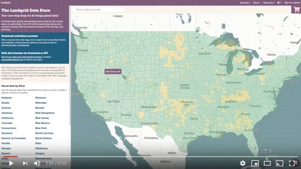
Here's a 30 second video tutorial on navigating & purchasing counties on the Landgrid data store -


With this launch, we have made it even easier for you to license our comprehensive parcel data from us - without any hassles or delays.

Here is the pricing:
CSV Data:

  • $100 for a spreadsheet of all Standard property information in any county
  • $200 for a county spreadsheet of all Premium property information, including vacancy and building counts

Shapefiles:

  • $200 for a shapefile of all Standard property information and parcel geometry in any county
  • $400 for a county shapefile of all Premium property information and parcel geometry, including vacancy and building counts

To take all of the mystery out of it, here’s exactly how the Landgrid Data Store experience works:

  1. Open the data store – landgrid.com/store. Here you will find our coverage map on the right. Green indicates places that we have data for and yellow indicates places that we are working on adding data for this year. You can also find our data dictionary of our standard schema and our coverage report for your review on the overview page. We encourage you to clearly assess the schema and the coverage report to ensure you know exactly what you would get from our data.
  2. On the overview tab, at the bottom you will find all the states listed. Based on the data you are looking for, you can select the state either here or from the coverage map.
  3. Once you select a state, you will find a list of all the counties in the state. When you are on the county page, make sure to download a “Sample” of the data for that county. We want to give you everything you need to make an informed decision before purchasing the data. 
  4. Once you are convinced that you are getting what you need, select the counties & the data format you want and simply “Add to Cart”.  Add a credit card and complete the transaction. Don’t worry. Our transactions are PCI compliant and your payment information remains secure. 
  5. You will instantly receive a confirmation email with your order details and a link to download your files. Follow the link and voila, your parcel data files at your door step in no time at all. Please note that this link stays active for a month, so be sure to download your files before the link expires.

Eezy Peezy! All this without any hassles or delays. 
A truly self-serve & seamless experience.  

We believe in transparency and making this process super easy for you. So at every step of the way you will have enough information so you know exactly what you are getting from us.

While the data store is amazing for downloading county data, if you are looking for the entire state or nationwide data access with timely data updates, then please write to us at parcels@landgrid.com and we will get you set up with it in no time.

Our bulk data prices are listed on our parcels page. We offer API access as well.

This was our March update. The team has worked so hard on this store and we are so happy & proud to be able to provide our standardized parcel data to more folks at a low price in a smooth interface. 

We will another update email coming to you soon about our nationwide land use code standardization and much more. Stay tuned with us!

Enjoy the data store and please give us your feedback on how we can improve your experience with it - team@landgrid.com

Happy Mapping!


Previous Next
logo

(888) 4RE-GRID

  • Contact Us
  • Customer Support
  • Privacy Policy
  • Terms of Use
  • Cookie Preferences

Subscribe for email updates

Company

  • About Regrid
  • Careers
  • Press
  • Shop Regrid Merch

Resources

  • Coverage Map
  • Support Center
  • Reports
  • Regrid Status Page

Enterprise Solutions

  • U.S. Parcels
  • Canada Parcels
  • Parcel & Tiles API
  • Roadway Right-of-Way

Self-Serve Solutions

  • Regrid Property App
  • Shop the Data Store
  • API Monthly Plans