


.png)


.svg)


Regrid Pro - A GIS Tool for Everyone!
This year Loveland has seen many changes and milestones. All of which we are so proud of.
Our suite of products now sits under the umbrella of the Regrid mapping platform & Regrid nationwide parcel data. We launched our nationwide parcel dataset this year. We are constantly working on refreshing our data and will soon be close to an average parcel age of under a year!
But through all this, the one thing that hasn’t changed is the core essence of our mapping platform that literally provides the American land grid in a beautiful, GIS interface to everyone.
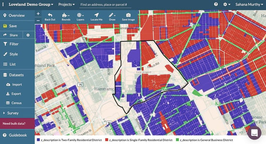
Of course, the interface has changed & gotten better over the years but our roots have remained the same. Helping individuals all over the country in discovering parcel-level information in their region in an easy-to-use, spatial map interface! At the core of it is the Regrid Pro solution that allows people like you and me to make maps, color code them, filter them, conduct land surveys, and generally look up parcels anywhere in the country.
For someone like me who's looking to buy a home soon, this is the ideal tool.
Within minutes I can look up properties that I would like to pursue, gauge what a neighborhood is like, who the top owners are in my county, and find relevant census information for my location.
You can experience this tool too by simply signing up for Regrid Pro or Regrid Free.
Our free version will give you a taste of what we offer. But the Pro provides you with limitless functionality & features all for $10/month or discounted at $100/year.
Soon, you will be on your way to making beautiful color-coded maps & surveys.
Here’s a quick snapshot of all you get with Pro:
- Unlimited Maps - Create as many beautiful maps and import as much data as you want.
- Import and export- Import & geocode your own data to parcels. Once you are done with your map, export your data as a CSV or shapefile or KML.
- Bookmarking - Bookmark properties that you find interesting by clicking the “+” button next to the address.
- Focus Area - Create a custom boundary on your map by drawing a focus area.
- Style & share - Style your data to create beautiful parcel maps, then embed or share your map with others.
- Measuring tool - Use our slick measuring tool to measure distances, areas and acreage. No more guessing!
- Multiple Layers - Add multiple layers like FEMA flood hazard or land cover to your map in addition to your base layers.
- Unlimited Surveys - Create an unlimited number of land surveys using our survey editor. The editor comes pre-built with questions if you want them but you can also generate your own survey questions to meet your project needs.
Phew… We are not yet done! There is more to Pro, like the ability to filter your data to get deeper insights.
Still not sure -- Check out our video tutorials. They will help you understand every facet of Pro - - see how easy, simple & user-friendly this tool really is.
No GIS experience is required. I should know - I have no GIS experience too but I was able to make a map in just a few minutes after getting set up.
Sign up today and be on your way to making insightful, color-coded parcel maps & surveys - https://regrid.com/plans
Sahana Murthy
GM | Regrid
Have questions? Want to evaluate our dataset? Get in touch with our team at parcels@regrid.com.
Learn more about our Nationwide Parcel Data, our schema, pricing and coverage here.
Regrid is an industry-leading property data and location intelligence company. We serve an array of industries that require land parcels and spatial data at scale, including real estate, insurance, energy, infrastructure, agriculture, logistics, and government.
