

regrid_tm_forest
Sign In
  • Products ⌄

    Regrid premium parcel data menu icon Premium parcels

    • global-icon Global parcels
    • US Parcel Data U.S. parcels
    • Europe-icon-navigation European parcels
    • Canada Parcel Data Canadian parcels
    • map-location-pin-regrid-icon U.S. coverage map

    ai-ml-navigation-icon (1) AI and ML tools

    • mcp-server-navigation MCP Server

    roadway-row-icon_2025-1 Roadway ROW

    • roadway-row-icon_2025 U.S. roadway polygons

    Spatial add-ons menu icon Spatial add-ons

    • Matched building footprints menu icon Matched building footprints
    • Matched secondary addresses menu icon Matched secondary addresses
    • Standardized zoning menu icon Standardized zoning
    • Enhanced property ownership menu icon Daily ownership updates

    Data access icon Delivery methods

    • Bulk files icon Bulk files
    • Feature Service Feature service
    • api-icon_2025 Parcel API and tiles
    • API Sandbox icon Interactive API sandbox
  • Industries ⌄

    industries-we-serve Industries we serve

    • aec-navigation-icon Architecture, engineering, and construction (AEC)
    • re-navigation-icon Real estate
    • gov-navigation-icon Government
    • ag-navigation-icon Agriculture
    • energy-navigation-icon Renewable energy and utilities
    • telco-navigation-icon Broadband and telecommunications
    • insurance-navigation-icon Insurance and finance
    • ai-ml-navigation-icon AI and machine learning
    • transportation-navigation-icon Transportation and logistics
  • Data store
  • Property App
  • Esri users
  • Resources ⌄

    Support menu icon Support

    • Support site menu icon Support site
    • Tutorial videos menu icon Tutorial videos
    • blog_resources_icon-1 Parcel schema
    • Regrid icon Sign into the Regrid Property App

    Content menu icon Content

    • Blog menu icon Blog
    • Customer stories menu icon Customer Stories
    • Reports menu icon Reports
    • data-store-2 Coverage map

    Programs menu icon Programs

    • academia_menu-icon Nonprofit & Academia
    • Regrid giving menu icon Regrid Giving
    • dwp-navigation-icon copy Data with Purpose

    shop icon Shop

    • merch_icon_2025 Regrid Merch
  • Contact us
Contact us
  • Products ⌄

    Premium parcels

    • Global parcels
    • U.S. parcels
    • European parcels
    • Canadian parcels
    • U.S. coverage map

    Spatial add-ons

    • Matched building footprints
    • Matched secondary addresses
    • Standardized zoning
    • Daily ownership updates

    AI and ML tools

    • MCP Server

    Delivery methods

    • Bulk files
    • Feature service
    • Parcel API and tiles
    • Interactive API sandbox

    Roadway ROW

    • U.S. roadway polygons
  • Industries ⌄

    Industries we serve

    • Architecture, engineering, and construction (AEC)
    • Real estate
    • Government
    • Agriculture
    • Renewable energy and utilities
    • Broadband and telecommunications
    • Insurance and finance
    • AI and machine learning
    • Transportation and logistics
  • Data store
  • Property App
  • Esri users
  • Resources ⌄

    Support

    • Support site
    • Tutorial videos
    • Parcel schema
    • Sign into the Regrid Property App

    Programs

    • Nonprofit & Academia
    • Regrid Giving
    • Data with Purpose

    Content

    • Blog
    • Customer Stories
    • Reports
    • Coverage map

    Shop

    • Regrid Merch
  • Contact us

DELIVERY METHODS

Enterprise-ready parcel data the way your team works

Regrid gives you flexible ways to access standardized parcel data, so you can bring it into the tools, pipelines, maps, and applications your team already uses.
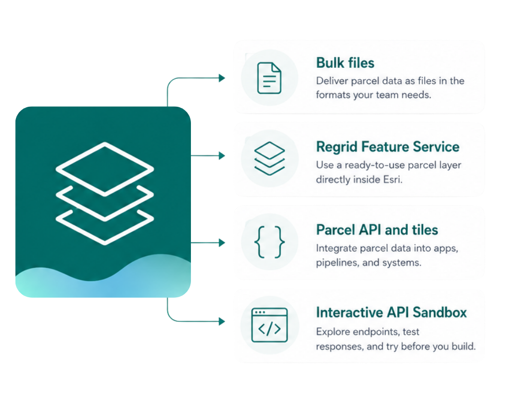
Delivery methods overview cards next to data stack

Choose the right delivery method for your enterprise workflow

bulk files

For teams that need parcel data delivered as files for internal databases, cloud workflows, GIS systems, analytics pipelines, or recurring enterprise use. Regrid bulk files are available in a range of formats, including CSV, FileGDB, GeoJSON, GeoPackage, Shapefile, SQL, and Parquet, with options designed for different technical environments.
Explore bulk file delivery

Regrid feature service

For teams that want Regrid parcel data delivered directly into Esri. The Regrid Feature Service gives Esri users a ready-to-use parcel layer that works with ArcGIS Pro, ArcGIS Online, ArcGIS SDKs, and other Esri-based workflows. Regrid hosts and serves the data, so your team can focus on using parcel intelligence instead of managing another dataset.
Explore Regrid Feature Service

Parcel API and tiles

For developers, software teams, AI workflows, and data products that need parcel data on demand. Use Regrid’s API and tiles to power applications, automate lookups, run data pipelines, support search and filtering, or bring parcel context into your own products and systems.
Build with Regrid

Regrid Property app

For fast parcel lookup, saved places, notes, fieldwork, parcel tracking, and property research. Use the Property App when you want an interactive parcel research tool rather than a data delivery pipeline.
Try the Property App

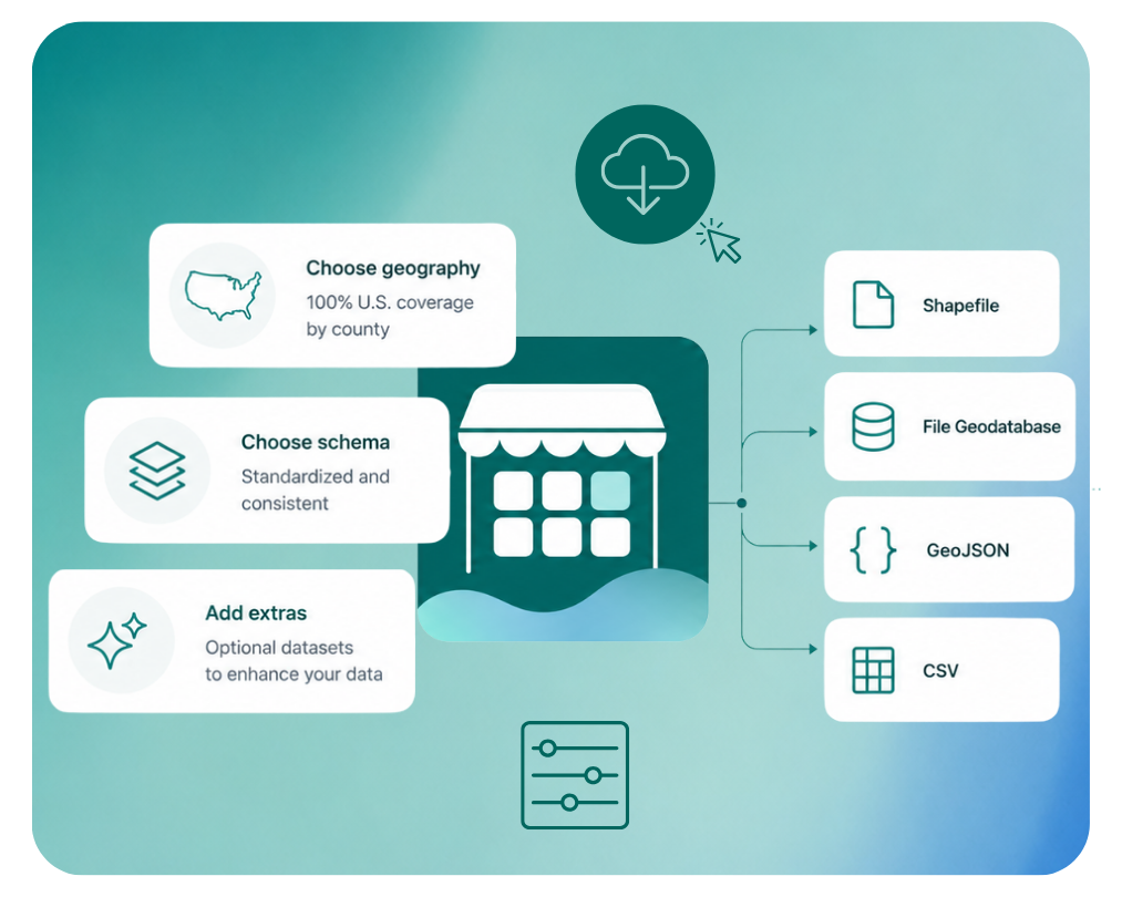
Looking for on-demand, self-serve access to Regrid data?

Check out the Regrid Data Store

For self-serve county and state downloads.

Use the Data Store when you need on-demand parcel data for your own tools and systems, without setting up an enterprise delivery.
Shop the Data Store
Data store depiction with value propositions and output formats
logo

(888) 4RE-GRID

  • Contact Us
  • Customer Support
  • Privacy Policy
  • Terms of Use
  • Cookie Preferences

Subscribe for email updates

Company

  • About Regrid
  • Careers
  • Press
  • Shop Regrid Merch

Resources

  • Coverage Map
  • Support Center
  • Reports
  • Regrid Status Page

Enterprise Solutions

  • U.S. Parcels
  • Canada Parcels
  • Parcel & Tiles API
  • Roadway Right-of-Way

Self-Serve Solutions

  • Regrid Property App
  • Shop the Data Store
  • API Monthly Plans





































