














regrid_tm_forest
Sign In
  • Products ⌄

    Regrid premium parcel data menu icon Premium parcels

    • global-icon Global parcels
    • US Parcel Data U.S. parcels
    • Europe-icon-navigation European parcels
    • Canada Parcel Data Canadian parcels
    • map-location-pin-regrid-icon U.S. coverage map

    ai-ml-navigation-icon (1) AI and ML tools

    • mcp-server-navigation MCP Server

    roadway-row-icon_2025-1 Roadway ROW

    • roadway-row-icon_2025 U.S. roadway polygons

    Spatial add-ons menu icon Spatial add-ons

    • Matched building footprints menu icon Matched building footprints
    • Matched secondary addresses menu icon Matched secondary addresses
    • Standardized zoning menu icon Standardized zoning
    • Enhanced property ownership menu icon Daily ownership updates

    Data access icon Delivery methods

    • Bulk files icon Bulk files
    • Feature Service Feature service
    • api-icon_2025 Parcel API and tiles
    • API Sandbox icon Interactive API sandbox
  • Industries ⌄

    industries-we-serve Industries we serve

    • aec-navigation-icon Architecture, engineering, and construction (AEC)
    • re-navigation-icon Real estate
    • gov-navigation-icon Government
    • ag-navigation-icon Agriculture
    • energy-navigation-icon Renewable energy and utilities
    • telco-navigation-icon Broadband and telecommunications
    • insurance-navigation-icon Insurance and finance
    • ai-ml-navigation-icon AI and machine learning
    • transportation-navigation-icon Transportation and logistics
  • Data store
  • Property App
  • Esri users
  • Resources ⌄

    Support menu icon Support

    • Support site menu icon Support site
    • Tutorial videos menu icon Tutorial videos
    • blog_resources_icon-1 Parcel schema
    • Regrid icon Sign into the Regrid Property App

    Content menu icon Content

    • Blog menu icon Blog
    • Customer stories menu icon Customer Stories
    • Reports menu icon Reports
    • data-store-2 Coverage map

    Programs menu icon Programs

    • academia_menu-icon Nonprofit & Academia
    • Regrid giving menu icon Regrid Giving
    • dwp-navigation-icon copy Data with Purpose

    shop icon Shop

    • merch_icon_2025 Regrid Merch
  • Contact us
Contact us
  • Products ⌄

    Premium parcels

    • Global parcels
    • U.S. parcels
    • European parcels
    • Canadian parcels
    • U.S. coverage map

    Spatial add-ons

    • Matched building footprints
    • Matched secondary addresses
    • Standardized zoning
    • Daily ownership updates

    AI and ML tools

    • MCP Server

    Delivery methods

    • Bulk files
    • Feature service
    • Parcel API and tiles
    • Interactive API sandbox

    Roadway ROW

    • U.S. roadway polygons
  • Industries ⌄

    Industries we serve

    • Architecture, engineering, and construction (AEC)
    • Real estate
    • Government
    • Agriculture
    • Renewable energy and utilities
    • Broadband and telecommunications
    • Insurance and finance
    • AI and machine learning
    • Transportation and logistics
  • Data store
  • Property App
  • Esri users
  • Resources ⌄

    Support

    • Support site
    • Tutorial videos
    • Parcel schema
    • Sign into the Regrid Property App

    Programs

    • Nonprofit & Academia
    • Regrid Giving
    • Data with Purpose

    Content

    • Blog
    • Customer Stories
    • Reports
    • Coverage map

    Shop

    • Regrid Merch
  • Contact us

The Regrid Blog

Discover the Latest in Land Parcels & Spatial Data with the Regrid Team!

Categories

  • Announcements
  • Parcel Data Updates
  • Democratizing Data
  • Regrid Updates
  • Product How-To
  • Use Cases
  • All About Parcel Data
  • Customer & Guest Blogs
  • Working at Regrid
  • Regrid 100
  • Reports

The New Land Grid Enterprise

Sahana Murthy May 15, 2019

Have you heard - Land Grid’s Enterprise account just got bigger and better!

Bigger because Enterprise now covers a broad spectrum of projects, no matter the size & scale. Better because we can now cater to a wide range of your needs and a wide range of customers!

Over the years, at Loveland we have tried to help our customers in every way we can. A recent introspection showed us that we have successfully offered a broad range of services and solutions to our customers, irrespective of the size and scale of their needs.
What does that really mean?

Simply put we have been able to offer solutions such as providing multiple group accounts on our mapping platform to taking on massive statewide & citywide data programs.
So instead of putting them under different buckets and giving them different names, we just want to say to you - Just come to us with any or all of your land parcel data, mapping and/or survey needs, we will find a way to do it for you.
That is essentially the NEW LAND GRID ENTERPRISE
Simpler, stronger, bigger & better….

Let me get into some details:
I have listed below a good set of benefits that we could offer to you as part of Enterprise.
I say "could" because every enterprise package would now be different.
Based on your needs, size & scale, we can personalize the features and benefits best suited for you. So , essentially you could end up getting a certain combination of these value propositions or end up getting all of them. We will price it accordingly too.

Really, YOU can drive what your Enterprise could look like! That’s the beauty of this package. :)

Here are some of the custom benefits of Land Grid’s Enterprise:

* Data importing - You can have our team help import data you already have into your account.
* Add collaborators - Invite and edit maps with coworkers in real time, see what others are seeing, and allow anyone to start working with property data on our user-friendly platform, regardless of past GIS experience.
* Account Manager - Depending on your project, we can assign you an account manager to make sure you’re never left wondering how to do something.
* Survey expertise - Over the years, the team at Loveland has built up a ton of expertise with all things parcels & property management, including large-scale survey or door-to-door campaigns. Let our experts help you with your survey needs.
* Reports & Analysis - If you’d like our team to write and package a report about findings in your data or the outcome of a survey, we’d be happy to do that for you.

Oh wait… These are just some of our basic features. We offer a multitude of custom add ons in addition to what you see here so far.
Sky's the limit! Pick and choose what you want.
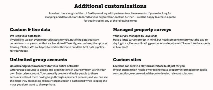
Additional customizations available.


Does any of this resonate with you? Are you or someone you love a county, city or a state that needs a well planned data & property management project done well? Let us know here - https://landgrid.com/enterprise#contactus.

I’m sure there are more ways we can service, we just need to know what you are looking for. Contact us at enterprise@landgrid.com and we will find a solution for you.
Meanwhile, please check out our Enterprise page (https://landgrid.com/enterprise) to get more information.

Feel free to reach out to me at sahana@landgrid.com, if you have any questions or want to discuss your project further.

Previous Next
logo

(888) 4RE-GRID

  • Contact Us
  • Customer Support
  • Privacy Policy
  • Terms of Use
  • Cookie Preferences

Subscribe for email updates

Company

  • About Regrid
  • Careers
  • Press
  • Shop Regrid Merch

Resources

  • Coverage Map
  • Support Center
  • Reports
  • Regrid Status Page

Enterprise Solutions

  • U.S. Parcels
  • Canada Parcels
  • Parcel & Tiles API
  • Roadway Right-of-Way

Self-Serve Solutions

  • Regrid Property App
  • Shop the Data Store
  • API Monthly Plans
























