


.png)


.svg)


February Parcel Update 2022
A detail of updates in January of 2022 and the upcoming pipeline is below.
48 newly added counties - Please see below for a list of newly added counties indicated by the * asterisk.
Changes to county table "Layer Names" - Completed
We updated our processes to change all layer names and county file names to make use of underscore characters ( _ ) instead of dash characters ( - ).
Verse table is now available via API - In addition to a file included with data deliveries, we are now providing our verse table as an easy-to-use API. The verse table includes county-by-county metadata including the date we last refreshed a county's data and a predictable filename for bulk files.
You can access this endpoint & the documentation for it by clicking here. The verse endpoint may reflect data updates before they are available in bulk files. The verse file included with your bulk data deliveries will always reflect the current state of data available to you.
Coverage Report: Updated for this month and available here.

A machine-readable version of this list is included in the `verse` table available in all the formats above as well as CSV format for use in spreadsheets. To find the latest updates in verse, sort by 'last_refresh' and use the 'filename_stem' column to identify the file.
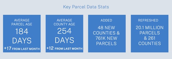
Data refreshed or added:
(Asterisk * indicates newly added county.)
AK - Aleutians West Census Area*, Anchorage, Bethel Census Area*, Bristol Bay Borough*, Dillingham Census Area, Fairbanks North Star Borough, Haines Borough, Juneau, Kenai Peninsula Borough, Ketchikan Gateway Borough, Kodiak Island Borough, Matanuska-Susitna Borough, Nome Census Area, Petersburg, Wrangell, Yakutat
AZ - Graham, La Paz, Maricopa
CA - Colusa, Monterey, San Diego, San Mateo, Shasta, Siskiyou, Tuolumne
CO - Ouray, Pitkin
DC - Washington
FL - Polk
IA - Decatur
ID - Benewah, Franklin, Twin Falls
IL - Johnson*, Saline*
IN - Lake
KY - Adair*, Anderson*, Ballard, Barren*, Bath*, Boyd*, Bracken*, Butler*, Caldwell*, Calloway*, Casey*, Clinton*, Crittenden*, Edmonson*, Floyd*, Fulton*, Green*, Harlan*, Johnson*, Knox*, Larue*, Leslie*, Lewis*, Lincoln*, Livingston*, Lyon*, Mason*, Meade*, Metcalfe*, Monroe*, Morgan*, Muhlenberg*, Nicholas*, Owsley*, Russell*
LA - Caldwell, Jefferson Davis
MI - Antrim*, Arenac, Genesee, Grand Traverse, Ingham, Iosco*, Kent, Lenawee*, Monroe, Ottawa, Saginaw, Tuscola, Wayne
MN - Lac qui Parle*
MO - Cass
MS - Adams, Alcorn, Amite, Attala, Benton, Bolivar, Calhoun, Chickasaw, Clarke, Clay, Coahoma, Copiah, Covington, Forrest, Grenada, Hancock, Harrison, Holmes, Itawamba, Jackson, Jasper, Jefferson, Jones, Lafayette, Lamar, Lauderdale, Lawrence, Leake, Leflore, Lowndes, Madison, Marion, Monroe, Montgomery, Neshoba, Newton, Noxubee, Oktibbeha, Panola, Pearl River, Pike, Pontotoc, Prentiss, Quitman, Rankin, Scott, Simpson, Smith, Stone, Sunflower, Tate, Tippah, Tishomingo, Tunica, Union, Walthall, Warren, Wayne, Webster, Winston
NC - Forsyth, Guilford
NE - Douglas
NM - Quay*
NV - Clark
OH - Franklin, Logan
OK - Rogers, Tulsa
OR - Clackamas, Grant, Lane, Tillamook
PA - Adams, Beaver, Bedford, Berks, Blair, Bradford, Bucks, Butler, Cambria, Carbon, Centre, Chester, Clarion, Clearfield, Clinton, Columbia, Crawford, Cumberland, Dauphin, Delaware, Fayette, Forest, Franklin, Fulton, Huntingdon, Juniata, Lackawanna, Lawrence, Lebanon, Lehigh, Luzerne, Lycoming, McKean, Mercer, Mifflin, Monroe, Montgomery, Montour, Northampton, Northumberland, Pike, Potter, Schuylkill, Snyder, Tioga, Union, Washington, Wayne, Westmoreland, Wyoming, York
SC - Richland
SD - Corson*
TX - Bell, El Paso, Hutchinson*, Montgomery, Tarrant
UT - Tooele
VA - Craig*, Lancaster
WA - Adams, Asotin, Benton, Chelan, Clallam, Clark, Columbia, Cowlitz, Douglas, Franklin, Garfield, Grant, Grays Harbor, Island, Jefferson, King, Kitsap, Kittitas, Klickitat, Lewis, Mason, Okanogan, Pacific, Pend Oreille, Pierce, San Juan, Skagit, Skamania, Snohomish, Spokane, Stevens, Thurston, Wahkiakum, Walla Walla, Whatcom, Yakima
WI - Milwaukee
In the current pipeline for updating in February 2022:
California
Hawaii
Idaho
Nevada
North Carolina
Wyoming
In the pipeline for updating in March 2022:
Oregon
Minnesota
Based on feedback and county challenges, pipeline planning is always subject to change. As always, please contact us if you have any questions about accessing or using the data, if you find issues with any of our data, or you have any comments or questions about our data in specific areas or states. We also love to hear from you about which counties or regions you'd like to see us update next, as it helps inform our planning process.
Thank you for being a part of Regrid!

