
-
Products ⌄
 Premium parcels
.png) AI and ML tools
AI and ML tools
 Roadway ROW
 Spatial add-ons
 Delivery methods
- Industries ⌄
- Data store
- Property App
- Esri users
-
Resources ⌄
 Content
 Programs
.png) Shop
Shop
- Contact us









.svg)

.png)























-
Products ⌄
AI and ML tools
Roadway ROW
-
Industries ⌄
-
Resources ⌄
Jump straight to:
Start with the source of the geometry
Don't judge parcel geometry from aerial imagery alone
Understand how the provider handles spatial problems
Parcel geometry is not survey-quality data
Evaluate geometry against the needs of the workflow
Questions to ask when evaluating parcel boundary quality
Understanding the quality of parcel boundaries
Parcel boundaries are different from ordinary parcel attributes.
A field such as owner name or tax year can be evaluated by looking at its source, coverage, and currency. Geometry also needs to be assessed spatially: where the boundary came from, how it was processed, what validation was performed, and whether its level of precision is appropriate for the intended use.
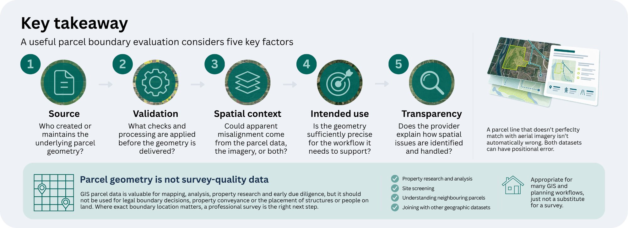
Visual inspection can help identify potential issues, but a parcel line that does not perfectly align with aerial imagery is not automatically wrong.
For teams using parcel geometry in GIS, site screening, property research, data integration or early due diligence, the appropriate level of precision depends on what the boundaries actually need to support.
Most parcel boundaries are created and maintained by local government sources.
At Regrid, our U.S. parcel geometry comes from authoritative county and county-designated sources. We aim to preserve that source geometry rather than making unwarranted changes simply to make the data look different or visually cleaner.
Those sources may have access to different levels of positional precision, reference information, and imagery when creating or maintaining their parcel data.
This means the quality and positional characteristics of source geometry can vary between jurisdictions.
When comparing providers, ask:
-
-
- Where does the underlying parcel geometry come from?
- Is the source authoritative for that jurisdiction?
- Does the provider preserve the source geometry or materially alter it?
- What happens when an obvious spatial problem is identified?
-
Understanding the source matters because a parcel-data provider is working with geometry created and maintained within local land-record systems. Evaluating the provider therefore also means understanding what they do (and deliberately do not do) to that source geometry before delivery.
One of the easiest ways to assess parcel data visually is to place parcel boundaries over aerial imagery.
That can be useful for identifying something worth investigating, but it can also be misleading.
The imagery used by a local source to georeference parcels is not always mapping-grade orthorectified imagery. Positional error can therefore sometimes be introduced when the parcel geometry is created or maintained.
The imagery used later to view the parcel can also contain positional error.
As a result, a parcel boundary may appear offset from a fence, building, road, or other visible feature even when the apparent problem is partly or entirely caused by the imagery.
People naturally tend to trust what they see in an aerial image, which makes this kind of misalignment easy to overinterpret. A visible disagreement is a reason to investigate further, but it does not establish which dataset is incorrect.
Parcel geometry can contain technical issues beyond simple visual alignment.
Our geometry-processing methodology includes visual checks for county completeness, standard geospatial processing to correct common polygon errors, and investigation of larger spatial problems such as shifts, skews or rotations. If a large-scale issue is identified, we work back with the source to have it corrected or look for an alternative authoritative source. Polygons that cannot be made valid through our standard processing are removed rather than delivered as usable geometry.
When evaluating a provider, ask:
-
-
- What validation is performed on incoming geometry?
- How are invalid polygons handled?
- What happens when a large shift, skew, or other spatial issue is detected?
- Does the provider investigate the source when there is a significant problem?
- Does it move parcel geometry simply to make it line up with imagery or another basemap?
-
We do not manually reposition authoritative parcel boundaries simply to make them align with aerial imagery or another basemap, because those reference datasets can themselves contain positional inaccuracies.
That's a crucial distinction. Making two layers look visually aligned is not necessarily the same thing as improving the underlying geometry.
GIS parcel data is useful for mapping, analysis, property research and understanding spatial relationships between parcels, but it has limits.
It should not be treated as a substitute for a professional survey or relied upon for decisions that require legally precise boundary location.
That includes uses such as:
-
-
- resolving legal boundary disputes;
- making final decisions about placing structures or personal property close to a parcel boundary;
- determining the exact legal location of people or property on land; or
- relying on the mapped boundary for property conveyance.
-
Where the exact legal location of a property boundary matters, the appropriate next step is to have the property surveyed.
Parcel geometry does not need to serve every possible spatial use case to be valuable.
For many workflows, GIS parcel boundaries are appropriate for:
-
-
- property research;
- spatial analysis;
- understanding neighboring parcels;
- site screening;
- mapping ownership or other parcel attributes;
- joining parcel information to other geographic datasets; and
- supporting applications where survey-level precision is not required.
-
The important evaluation question is whether the geometry is sufficiently reliable for the work you intend to do.
A workflow that needs to identify which parcel a property belongs to has very different precision requirements from one determining exactly where a structure can legally be placed.
Customer example: See how Immersive Homes uses Regrid for early site due diligence
Immersive Homes uses our parcel boundaries during early site due diligence, including exporting them to AutoCAD for initial concept work before a formal survey is available. The parcel geometry helps the team understand a site and begin early planning, while formal due diligence and surveying remain separate steps as the project progresses.

When comparing parcel-data providers, ask:
-
-
- Where does the underlying parcel geometry come from?
- Is the source authoritative for the jurisdiction?
- What validation and geometry processing are performed before delivery?
- How are invalid polygons handled?
- What happens when a larger shift, skew or rotation is identified?
- Does the provider manually alter authoritative geometry to match imagery or another basemap?
- How transparent is the provider about the limitations of the geometry?
- Is the level of precision appropriate for our intended workflow?
-
A strong evaluation considers source, methodology, spatial context and intended use together. Visual alignment alone is not enough to judge parcel-boundary quality.
Evaluate parcel data quality with confidence
Get the full framework for assessing currency, coverage, completeness, provenance, standardization, geometry, compliance, and overall fit for your workflow.

Our U.S. parcel geometry comes from authoritative county and county-designated sources. We aim to preserve that source data while applying quality-control and geometry-processing steps needed to make it usable in consistent GIS workflows.
As part of that process, we:
-
-
- visually inspect counties for completeness;
- use standard geospatial functions to correct common polygon errors;
- remove polygons that cannot be made valid through that process;
- investigate large-scale shifts, skews or rotations and work with the source (or seek another authoritative source, when necessary), and
- avoid manually repositioning parcel boundaries simply to make them line up with aerial imagery.
-
That last point matters because imagery can contain positional error too. A visually cleaner overlay is not automatically a more accurate representation of the authoritative parcel geometry.
📄 Read more about our parcel-data onboarding and geometry methodology
Smarter location decisions start here
-
Parcel geometry and aerial imagery are separate spatial datasets, and either can contain positional error. An apparent offset therefore does not automatically mean that the parcel geometry is wrong.
-
No. GIS parcel data should not be treated as survey-quality data. Where exact legal boundary location matters, a professional survey is appropriate.
-
Not automatically. Imagery can itself contain spatial inaccuracies, so visually aligning parcel geometry to a basemap does not necessarily improve its accuracy.
-
Look at the source of the geometry, the provider's validation and processing methodology, how spatial issues are handled, and whether the resulting geometry is suitable for the precision your workflow requires.


















(888) 4RE-GRID
Subscribe for email updates