Regrid logo, registered trademark
  • Enterprise

    Regrid premium parcel data menu icon Premium Parcels

    • US Parcel Data U.S. Parcels
    • Canada Parcel Data Canadian Parcels
    • global-icon Global Parcels

    Spatial add-ons menu icon Spatial Add-Ons

    • Matched building footprints menu icon Matched Building Footprints
    • Matched secondary addresses menu icon Matched Secondary Addresses
    • Standardized zoning menu icon Standardized Zoning
    • Enhanced property ownership menu icon Daily Ownership Updates

    road icon Roadway ROW

    • Roadway polygons icon U.S. Roadway Polygons

    Data access icon Data Access

    • data-store-2 Coverage Map
    • blog_resources_icon-1 Parcel Schema
    • Bulk files icon Bulk Files
    • Feature Service Feature Service
    • api-icon_2025 Parcel API & Tiles
    • API Sandbox icon Interactive API Sandbox
  • Data Store
  • Regrid App
  • Esri Users
  • Resources

    Support menu icon Support

    • Support site menu icon Support Site
    • Tutorial videos menu icon Tutorial Videos

    Content menu icon Content

    • Blog menu icon Blog
    • Customer stories menu icon Customer Stories
    • Reports menu icon Reports

    Programs menu icon Programs

    • academia_menu-icon Nonprofit & Academia
    • Regrid giving menu icon Regrid Giving
  • Contact Us
Contact Us
  • Enterprise

    Premium Parcels

    • U.S. Parcels
    • Canadian Parcels
    • Global Parcels

    Roadway ROW

    • U.S. Roadway Polygons

    Spatial Add-Ons

    • Matched Building Footprints
    • Matched Secondary Addresses
    • Standardized Zoning
    • Daily Ownership Updates

    Data Access

    • Coverage Map
    • Parcel Schema
    • Bulk Files
    • Feature Service
    • Parcel API & Tiles
    • Interactive API Sandbox
  • Data Store
  • Regrid App
  • Esri Users
  • Resources

    Support

    • Support Site
    • Tutorial Videos

    Programs

    • Nonprofit & Academia
    • Regrid Giving

    Content

    • Blog
    • Customer Stories
    • Reports
  • Contact Us

The Regrid Blog

Discover the Latest in Land Parcels & Spatial Data with the Regrid Team!

Regrid Blog

Living In The Map

  • Announcements
  • Parcel Data Updates
  • Democratizing Data
  • Regrid Updates
  • Product How-To
  • Use Cases
  • Customer & Guest Blogs
  • All About Parcel Data

Latest Blog Post

May 2025 Parcel Data Update

A detailed list of updates in April and a preview of the upcoming counties in our pipeline is below.

Read More
The Regrid Data Team on May 1, 2025

Categories

  • Announcements
  • Parcel Data Updates
  • Democratizing Data
  • Regrid Updates
  • Product How-To
  • Use Cases
  • Customer & Guest Blogs
  • All About Parcel Data
  • Working at Regrid
  • Regrid 100
  • Reports
How Regrid's Data With Purpose Program Helps the National Zoning Atlas Demystify Zoning

When the National Zoning Atlas set out on an ambitious project to democratize national zoning data, they came to Regrid's Data With Purpose program.... Read More

Alex Alsup
March 27, 2024
Out of state ownership, Phoenix, AZ
Owned Away from Home: Regrid Report on Ownership of U.S. Housing Stock

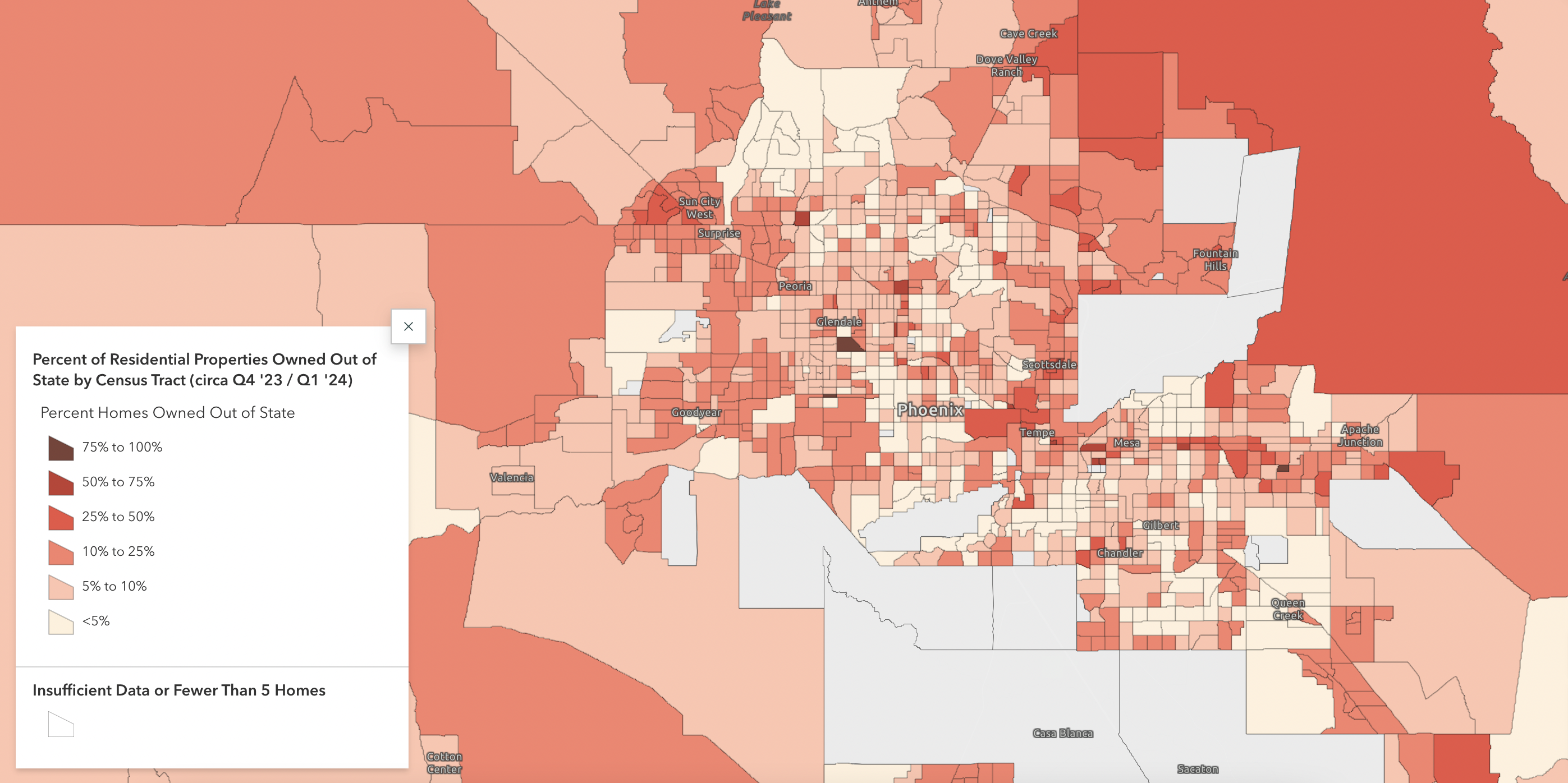
A new report from Regrid gives a unique, nationwide, look at the scale of U.S. homes owned outside their local areas. "Owned Away From Home,"... Read More

Alex Alsup
March 13, 2024
The US in a Square Inch
The United States, in a Square Inch

You’re going to hear a lot about where Regrid is going as we celebrate being the first to market with a 100% United States land parcel coverage map.... Read More

Alex Alsup
October 18, 2023
Making compelling parcel maps should be easy - Regrid + Felt
Purchased Parcel Data? Open In Felt.

Making compelling maps with parcel data should be easy. For more than a decade Regrid has worked tirelessly to make it easier to access and work... Read More

Alex Alsup
June 21, 2023
Detroit Assessment Gauge
Announcing the Detroit Assessment Gauge, from Regrid

We love seeing all the amazing things people do with Regrid’s nationwide parcel data, and are always thinking of new ways parcel data can provide... Read More

Alex Alsup
October 12, 2022
Tax Foreclosure & Vacant Homes on Detroit's Maiden Street

Northeast end of 11200 Block of Maiden Street, 2010 vs. 2016. Drag slider to see change. I've kept track of the neighborhood around the shuttered... Read More

Alex Alsup
August 12, 2016
Survey Property at Light Speed: Site Control + Street View

Evaluating Property with Site Control + Google Street View Are you a real estate appraiser who needs to collect parcel-level data on properties and... Read More

Alex Alsup
May 6, 2016
Digitizing Maps Showing Locations of Flint's Lead Pipes

Ari Shapiro from NPR posted a photo on Instagram with the caption: "These are the maps that will help people in #flint figure out which pipes are... Read More

Alex Alsup
January 30, 2016
A Recent History of Tax Foreclosure

Waves of tax foreclosed properties still crash on Detroit year after year. In 2016, absent any kind of large scale intervention, 60,000 more Detroit... Read More

Alex Alsup
November 9, 2015
Supporting Angels Thwarting Devils

(Areas of Concentration for Suspicious Fires, Arsons, and Occupied Homes Adjacent to Vacant Properties) Read More

Alex Alsup
October 26, 2015
  • Pre
  • 1
  • 2
  • Next

Subscribe

Subscribe to our newsletter & stay updated

logo

(888) 4RE-GRID

  • Contact Us
  • Customer Support
  • Privacy Policy
  • Terms of Use

Subscribe for email updates

Company

  • About Regrid
  • Careers
  • Press

Resources

  • Coverage Map
  • Support Center
  • Reports
  • Regrid Status Page

Enterprise Solutions

  • U.S. Parcels
  • Canada Parcels
  • Parcel & Tiles API

Self-Serve Solutions

  • Regrid Property App
  • Shop the Data Store
  • API Monthly Plans